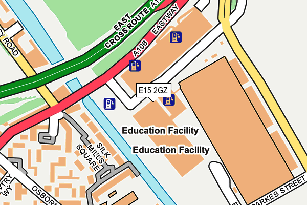
E15 2GZ is located in the Hackney Wick electoral ward, within the London borough of Hackney and the English Parliamentary constituency of Hackney South and Shoreditch. The Sub Integrated Care Board (ICB) Location is NHS North East London ICB - A3A8R and the police force is Metropolitan Police. This postcode has been in use since February 2016.


GetTheData
Source: OS OpenMap – Local (Ordnance Survey)
Source: OS VectorMap District (Ordnance Survey)
Licence: Open Government Licence (requires attribution)
| Easting | 537102 |
| Northing | 185151 |
| Latitude | 51.548603 |
| Longitude | -0.024061 |
GetTheData
Source: Open Postcode Geo
Licence: Open Government Licence
| Country | England |
| Postcode District | E15 |
| ➜ E15 open data dashboard ➜ See where E15 is on a map ➜ Where is Hackney? | |
GetTheData
Source: Land Registry Price Paid Data
Licence: Open Government Licence
Elevation or altitude of E15 2GZ as distance above sea level:
| Metres | Feet | |
|---|---|---|
| Elevation | 10m | 33ft |
Elevation is measured from the approximate centre of the postcode, to the nearest point on an OS contour line from OS Terrain 50, which has contour spacing of ten vertical metres.
➜ How high above sea level am I? Find the elevation of your current position using your device's GPS.
GetTheData
Source: Open Postcode Elevation
Licence: Open Government Licence
| Ward | Hackney Wick |
| Constituency | Hackney South And Shoreditch |
GetTheData
Source: ONS Postcode Database
Licence: Open Government Licence
| June 2022 | Violence and sexual offences | On or near Eastway | 71m |
| June 2022 | Anti-social behaviour | On or near East Cross Route | 286m |
| June 2022 | Anti-social behaviour | On or near East Cross Route | 286m |
| ➜ Get more crime data in our Crime section | |||
GetTheData
Source: data.police.uk
Licence: Open Government Licence
| Hereeast | Hackney Wick | 47m |
| Hereeast | Hackney Wick | 50m |
| Trowbridge Estate | Hackney Wick | 281m |
| Crowfoot Close (Lee Conservancy Road) | Hackney Wick | 313m |
| Crowfoot Close (Lee Conservancy Road) | Hackney Wick | 343m |
| Stratford International Dlr Station | Stratford | 1,069m |
| Leyton Underground Station | Leyton | 1,564m |
| Stratford Underground Station | Stratford | 1,618m |
| Stratford Dlr Station (Station Street) | Stratford | 1,631m |
| Hackney Wick Station | 0.6km |
| Stratford International Station | 1.1km |
| Homerton Station | 1.3km |
GetTheData
Source: NaPTAN
Licence: Open Government Licence
GetTheData
Source: ONS Postcode Database
Licence: Open Government Licence


➜ Get more ratings from the Food Standards Agency
GetTheData
Source: Food Standards Agency
Licence: FSA terms & conditions
| Last Collection | |||
|---|---|---|---|
| Location | Mon-Fri | Sat | Distance |
| Lee Conservancy Road | 17:00 | 11:30 | 494m |
| Eastway | 17:00 | 11:30 | 556m |
| Kingsmead Way | 17:00 | 11:30 | 775m |
GetTheData
Source: Dracos
Licence: Creative Commons Attribution-ShareAlike
| Facility | Distance |
|---|---|
| Gainsborough Playing Fields East Bay Lane, London Artificial Grass Pitch | 274m |
| Young Hackney Eastway Eastway, London Outdoor Tennis Courts | 414m |
| Hackney Marshes Centre (South Marsh) Homerton Road, Hackney, London Grass Pitches | 493m |
GetTheData
Source: Active Places
Licence: Open Government Licence
| School | Phase of Education | Distance |
|---|---|---|
| Gainsborough Primary School Berkshire Road, London, E9 5ND | Primary | 340m |
| Mossbourne Riverside Academy East Bay Lane, London, E15 2GW | Primary | 387m |
| Ickburgh School Kenworthy Road, Hackney, London, E9 5RB | Not applicable | 921m |
GetTheData
Source: Edubase
Licence: Open Government Licence
The below table lists the International Territorial Level (ITL) codes (formerly Nomenclature of Territorial Units for Statistics (NUTS) codes) and Local Administrative Units (LAU) codes for E15 2GZ:
| ITL 1 Code | Name |
|---|---|
| TLI | London |
| ITL 2 Code | Name |
| TLI4 | Inner London - East |
| ITL 3 Code | Name |
| TLI41 | Hackney and Newham |
| LAU 1 Code | Name |
| E09000012 | Hackney |
GetTheData
Source: ONS Postcode Directory
Licence: Open Government Licence
The below table lists the Census Output Area (OA), Lower Layer Super Output Area (LSOA), and Middle Layer Super Output Area (MSOA) for E15 2GZ:
| Code | Name | |
|---|---|---|
| OA | E00009202 | |
| LSOA | E01001846 | Hackney 018A |
| MSOA | E02000362 | Hackney 018 |
GetTheData
Source: ONS Postcode Directory
Licence: Open Government Licence
| E9 5NY | Windsor Wharf | 198m |
| E9 5JD | Eastway | 219m |
| E9 5NZ | Meadow Close | 237m |
| E9 5NX | Silkmills Square | 265m |
| E9 5NL | Southmoor Way | 287m |
| E9 5NJ | Chisledon Walk | 309m |
| E9 5JH | Eastway | 313m |
| E9 5PD | Corsley Way | 314m |
| E9 5LP | Leabank Square | 314m |
| E9 5NH | Semley Gate | 361m |
GetTheData
Source: Open Postcode Geo; Land Registry Price Paid Data
Licence: Open Government Licence