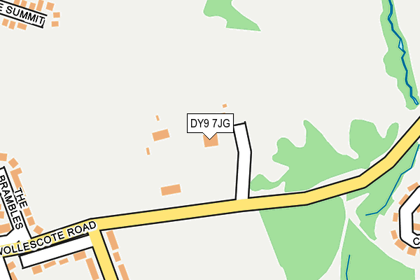
DY9 7JG is located in the Pedmore and Stourbridge East electoral ward, within the metropolitan district of Dudley and the English Parliamentary constituency of Stourbridge. The Sub Integrated Care Board (ICB) Location is NHS Black Country ICB - D2P2L and the police force is West Midlands. This postcode has been in use since January 1980.


GetTheData
Source: OS OpenMap – Local (Ordnance Survey)
Source: OS VectorMap District (Ordnance Survey)
Licence: Open Government Licence (requires attribution)
| Easting | 392121 |
| Northing | 283428 |
| Latitude | 52.448768 |
| Longitude | -2.117350 |
GetTheData
Source: Open Postcode Geo
Licence: Open Government Licence
| Country | England |
| Postcode District | DY9 |
| ➜ DY9 open data dashboard ➜ See where DY9 is on a map ➜ Where is Stourbridge? | |
GetTheData
Source: Land Registry Price Paid Data
Licence: Open Government Licence
Elevation or altitude of DY9 7JG as distance above sea level:
| Metres | Feet | |
|---|---|---|
| Elevation | 140m | 459ft |
Elevation is measured from the approximate centre of the postcode, to the nearest point on an OS contour line from OS Terrain 50, which has contour spacing of ten vertical metres.
➜ How high above sea level am I? Find the elevation of your current position using your device's GPS.
GetTheData
Source: Open Postcode Elevation
Licence: Open Government Licence
| Ward | Pedmore And Stourbridge East |
| Constituency | Stourbridge |
GetTheData
Source: ONS Postcode Database
Licence: Open Government Licence
| December 2023 | Anti-social behaviour | On or near Parking Area | 312m |
| November 2023 | Anti-social behaviour | On or near Parking Area | 312m |
| October 2023 | Violence and sexual offences | On or near Parking Area | 312m |
| ➜ Get more crime data in our Crime section | |||
GetTheData
Source: data.police.uk
Licence: Open Government Licence
| Wollescote Rd (Walker Ave) | Wollescote | 226m |
| Walker Avenue (Wollescote Rd) | Wollescote | 265m |
| Stevens Park (Springfield Ave) | Wollescote | 349m |
| Stevens Park (Springfield Ave) | Wollescote | 355m |
| Rye Croft (Walker Ave) | Wollescote | 429m |
| Stourbridge Junction Station | 1.1km |
| Lye (West Midlands) Station | 1.2km |
| Stourbridge Town Station | 1.8km |
GetTheData
Source: NaPTAN
Licence: Open Government Licence
GetTheData
Source: ONS Postcode Database
Licence: Open Government Licence


➜ Get more ratings from the Food Standards Agency
GetTheData
Source: Food Standards Agency
Licence: FSA terms & conditions
| Last Collection | |||
|---|---|---|---|
| Location | Mon-Fri | Sat | Distance |
| High Street | 18:45 | 10:45 | 104m |
| Lye Post Office | 18:45 | 11:00 | 1,006m |
| Chawn Park | 18:30 | 10:30 | 1,148m |
GetTheData
Source: Dracos
Licence: Creative Commons Attribution-ShareAlike
| Facility | Distance |
|---|---|
| Stevens Park (Wollescote) Wollescote Road, Wollescote Grass Pitches, Outdoor Tennis Courts | 62m |
| Pedmore High School Grange Lane, Stourbridge Sports Hall, Swimming Pool, Grass Pitches | 633m |
| Wollescote Primary School Drummond Road, Stourbridge Swimming Pool, Grass Pitches | 868m |
GetTheData
Source: Active Places
Licence: Open Government Licence
| School | Phase of Education | Distance |
|---|---|---|
| Hob Green Primary School Hob Green Road, Pedmore Fields, Stourbridge, DY9 9EX | Primary | 634m |
| The Pedmore High School Grange Lane, Pedmore, Stourbridge, DY9 7HS | Secondary | 636m |
| Wollescote Primary School Drummond Road, Wollescote, Stourbridge, DY9 8YA | Primary | 875m |
GetTheData
Source: Edubase
Licence: Open Government Licence
The below table lists the International Territorial Level (ITL) codes (formerly Nomenclature of Territorial Units for Statistics (NUTS) codes) and Local Administrative Units (LAU) codes for DY9 7JG:
| ITL 1 Code | Name |
|---|---|
| TLG | West Midlands (England) |
| ITL 2 Code | Name |
| TLG3 | West Midlands |
| ITL 3 Code | Name |
| TLG36 | Dudley |
| LAU 1 Code | Name |
| E08000027 | Dudley |
GetTheData
Source: ONS Postcode Directory
Licence: Open Government Licence
The below table lists the Census Output Area (OA), Lower Layer Super Output Area (LSOA), and Middle Layer Super Output Area (MSOA) for DY9 7JG:
| Code | Name | |
|---|---|---|
| OA | E00049878 | |
| LSOA | E01009860 | Dudley 042D |
| MSOA | E02002041 | Dudley 042 |
GetTheData
Source: ONS Postcode Directory
Licence: Open Government Licence
| DY9 9EA | Walker Avenue | 214m |
| DY9 9EB | Walker Avenue | 273m |
| DY9 7JQ | Wollescote Road | 277m |
| DY9 7JH | The Brambles | 284m |
| DY9 9EF | Carlton Avenue | 288m |
| DY9 9EE | Carlton Avenue | 315m |
| DY9 7HD | The Summit | 331m |
| DY9 9ED | Carlton Avenue | 336m |
| DY9 7HE | Beacon Rise | 350m |
| DY9 7JL | Ash Grove | 360m |
GetTheData
Source: Open Postcode Geo; Land Registry Price Paid Data
Licence: Open Government Licence