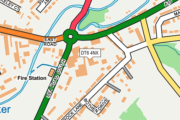
DT6 4NX is located in the Bridport electoral ward, within the unitary authority of Dorset and the English Parliamentary constituency of West Dorset. The Sub Integrated Care Board (ICB) Location is NHS Dorset ICB - 11J and the police force is Dorset. This postcode has been in use since October 2009.


GetTheData
Source: OS OpenMap – Local (Ordnance Survey)
Source: OS VectorMap District (Ordnance Survey)
Licence: Open Government Licence (requires attribution)
| Easting | 347209 |
| Northing | 92775 |
| Latitude | 50.732169 |
| Longitude | -2.749384 |
GetTheData
Source: Open Postcode Geo
Licence: Open Government Licence
| Country | England |
| Postcode District | DT6 |
| ➜ DT6 open data dashboard ➜ See where DT6 is on a map ➜ Where is Bridport? | |
GetTheData
Source: Land Registry Price Paid Data
Licence: Open Government Licence
Elevation or altitude of DT6 4NX as distance above sea level:
| Metres | Feet | |
|---|---|---|
| Elevation | 10m | 33ft |
Elevation is measured from the approximate centre of the postcode, to the nearest point on an OS contour line from OS Terrain 50, which has contour spacing of ten vertical metres.
➜ How high above sea level am I? Find the elevation of your current position using your device's GPS.
GetTheData
Source: Open Postcode Elevation
Licence: Open Government Licence
| Ward | Bridport |
| Constituency | West Dorset |
GetTheData
Source: ONS Postcode Database
Licence: Open Government Licence
| December 2023 | Anti-social behaviour | On or near Parking Area | 384m |
| September 2023 | Violence and sexual offences | On or near Parking Area | 384m |
| July 2023 | Anti-social behaviour | On or near Parking Area | 384m |
| ➜ Get more crime data in our Crime section | |||
GetTheData
Source: data.police.uk
Licence: Open Government Licence
| St Ronans School (Crock Lane) | Bridport | 124m |
| Toll House (East Road) | Bridport | 147m |
| The Toll House (East Road) | Bridport | 175m |
| East Street Bridge (East Street) | Bridport | 202m |
| East Bridge (East Street) | Bridport | 223m |
GetTheData
Source: NaPTAN
Licence: Open Government Licence
GetTheData
Source: ONS Postcode Database
Licence: Open Government Licence


➜ Get more ratings from the Food Standards Agency
GetTheData
Source: Food Standards Agency
Licence: FSA terms & conditions
| Last Collection | |||
|---|---|---|---|
| Location | Mon-Fri | Sat | Distance |
| East Road | 16:00 | 12:00 | 113m |
| Nursery Gardens | 17:15 | 12:00 | 321m |
| East Street | 17:30 | 12:00 | 533m |
GetTheData
Source: Dracos
Licence: Creative Commons Attribution-ShareAlike
| Facility | Distance |
|---|---|
| Bridport Primary School St. Andrews Road, Bridport Grass Pitches | 578m |
| Bridport Youth & Community Centre Gundry Lane, Bridport Sports Hall | 773m |
| Bridport Social & Education Centre (Closed) Flood Lane, Bridport Grass Pitches | 899m |
GetTheData
Source: Active Places
Licence: Open Government Licence
| School | Phase of Education | Distance |
|---|---|---|
| Bridport Primary School St Andrew's Road, Bridport, DT6 3BJ | Primary | 486m |
| St Catherine's Roman Catholic School Pymore Road, Bridport, DT6 3TR | Primary | 1.1km |
| Bridport, St Mary's Church of England Primary School Skilling Hill Road, Bridport, DT6 5LA | Primary | 1.3km |
GetTheData
Source: Edubase
Licence: Open Government Licence
| Risk of DT6 4NX flooding from rivers and sea | Medium |
| ➜ DT6 4NX flood map | |
GetTheData
Source: Open Flood Risk by Postcode
Licence: Open Government Licence
The below table lists the International Territorial Level (ITL) codes (formerly Nomenclature of Territorial Units for Statistics (NUTS) codes) and Local Administrative Units (LAU) codes for DT6 4NX:
| ITL 1 Code | Name |
|---|---|
| TLK | South West (England) |
| ITL 2 Code | Name |
| TLK2 | Dorset and Somerset |
| ITL 3 Code | Name |
| TLK25 | Dorset |
| LAU 1 Code | Name |
| E06000059 | Dorset |
GetTheData
Source: ONS Postcode Directory
Licence: Open Government Licence
The below table lists the Census Output Area (OA), Lower Layer Super Output Area (LSOA), and Middle Layer Super Output Area (MSOA) for DT6 4NX:
| Code | Name | |
|---|---|---|
| OA | E00103940 | |
| LSOA | E01020503 | West Dorset 008B |
| MSOA | E02004276 | West Dorset 008 |
GetTheData
Source: ONS Postcode Directory
Licence: Open Government Licence
| DT6 4AA | East Road | 47m |
| DT6 4DE | Crock Lane | 96m |
| DT6 4DA | Asker Mead | 97m |
| DT6 3HA | East Road | 127m |
| DT6 3XA | Sea Road South | 134m |
| DT6 4AG | East Road | 168m |
| DT6 4DJ | Bothen Drive | 172m |
| DT6 4EE | 182m | |
| DT6 3LW | East Street | 213m |
| DT6 3LS | Melville Square | 215m |
GetTheData
Source: Open Postcode Geo; Land Registry Price Paid Data
Licence: Open Government Licence