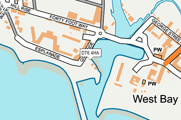
DT6 4HA is located in the Bridport electoral ward, within the unitary authority of Dorset and the English Parliamentary constituency of West Dorset. The Sub Integrated Care Board (ICB) Location is NHS Dorset ICB - 11J and the police force is Dorset. This postcode has been in use since January 1980.


GetTheData
Source: OS OpenMap – Local (Ordnance Survey)
Source: OS VectorMap District (Ordnance Survey)
Licence: Open Government Licence (requires attribution)
| Easting | 346264 |
| Northing | 90489 |
| Latitude | 50.711526 |
| Longitude | -2.762439 |
GetTheData
Source: Open Postcode Geo
Licence: Open Government Licence
| Country | England |
| Postcode District | DT6 |
| ➜ DT6 open data dashboard ➜ See where DT6 is on a map ➜ Where is Bridport? | |
GetTheData
Source: Land Registry Price Paid Data
Licence: Open Government Licence
Elevation or altitude of DT6 4HA as distance above sea level:
| Metres | Feet | |
|---|---|---|
| Elevation | 10m | 33ft |
Elevation is measured from the approximate centre of the postcode, to the nearest point on an OS contour line from OS Terrain 50, which has contour spacing of ten vertical metres.
➜ How high above sea level am I? Find the elevation of your current position using your device's GPS.
GetTheData
Source: Open Postcode Elevation
Licence: Open Government Licence
| Ward | Bridport |
| Constituency | West Dorset |
GetTheData
Source: ONS Postcode Database
Licence: Open Government Licence
| January 2024 | Anti-social behaviour | On or near Parking Area | 163m |
| January 2024 | Anti-social behaviour | On or near Parking Area | 270m |
| November 2023 | Other theft | On or near Parking Area | 62m |
| ➜ Get more crime data in our Crime section | |||
GetTheData
Source: data.police.uk
Licence: Open Government Licence
| The George | West Bay | 65m |
| Meadowlands (West Bay Road) | West Bay | 447m |
| Meadowlands (West Bay Road) | West Bay | 453m |
| Roundham Gardens (West Bay Road) | Bridport | 949m |
| Opposite Roundham Gardens (West Bay Road) | Bridport | 982m |
GetTheData
Source: NaPTAN
Licence: Open Government Licence
GetTheData
Source: ONS Postcode Database
Licence: Open Government Licence


➜ Get more ratings from the Food Standards Agency
GetTheData
Source: Food Standards Agency
Licence: FSA terms & conditions
| Last Collection | |||
|---|---|---|---|
| Location | Mon-Fri | Sat | Distance |
| West Bay P.o. | 16:45 | 12:00 | 116m |
| West Cliff | 16:00 | 12:00 | 522m |
| Burton Road | 16:00 | 12:00 | 902m |
GetTheData
Source: Dracos
Licence: Creative Commons Attribution-ShareAlike
| Facility | Distance |
|---|---|
| Bridport And West Dorset Golf Club Burton Road, Bridport Golf | 1.2km |
| Highlands End Farm Leisure Club Highlands End, Eype Swimming Pool, Health and Fitness Gym, Outdoor Tennis Courts | 1.5km |
| Bridport Leisure Centre Skilling Hill Road, Bridport Sports Hall, Swimming Pool, Health and Fitness Gym, Grass Pitches, Studio, Squash Courts | 1.6km |
GetTheData
Source: Active Places
Licence: Open Government Licence
| School | Phase of Education | Distance |
|---|---|---|
| Bridport, St Mary's Church of England Primary School Skilling Hill Road, Bridport, DT6 5LA | Primary | 1.7km |
| Burton Bradstock Church of England Voluntary Controlled School Church Street, Burton Bradstock, Bridport, DT6 4QS | Primary | 2.8km |
| Bridport Primary School St Andrew's Road, Bridport, DT6 3BJ | Primary | 2.9km |
GetTheData
Source: Edubase
Licence: Open Government Licence
| Risk of DT6 4HA flooding from rivers and sea | Medium |
| ➜ DT6 4HA flood map | |
GetTheData
Source: Open Flood Risk by Postcode
Licence: Open Government Licence
The below table lists the International Territorial Level (ITL) codes (formerly Nomenclature of Territorial Units for Statistics (NUTS) codes) and Local Administrative Units (LAU) codes for DT6 4HA:
| ITL 1 Code | Name |
|---|---|
| TLK | South West (England) |
| ITL 2 Code | Name |
| TLK2 | Dorset and Somerset |
| ITL 3 Code | Name |
| TLK25 | Dorset |
| LAU 1 Code | Name |
| E06000059 | Dorset |
GetTheData
Source: ONS Postcode Directory
Licence: Open Government Licence
The below table lists the Census Output Area (OA), Lower Layer Super Output Area (LSOA), and Middle Layer Super Output Area (MSOA) for DT6 4HA:
| Code | Name | |
|---|---|---|
| OA | E00103946 | |
| LSOA | E01020504 | West Dorset 008C |
| MSOA | E02004276 | West Dorset 008 |
GetTheData
Source: ONS Postcode Directory
Licence: Open Government Licence
| DT6 4EZ | Riverside | 90m |
| DT6 4EU | 111m | |
| DT6 4ER | Pier Terrace | 113m |
| DT6 4EY | George Street | 123m |
| DT6 4EN | 142m | |
| DT6 4EX | Swains Row | 149m |
| DT6 4GZ | Quayside | 150m |
| DT6 4HD | 165m | |
| DT6 4EW | Station Road | 179m |
| DT6 4EL | 181m |
GetTheData
Source: Open Postcode Geo; Land Registry Price Paid Data
Licence: Open Government Licence