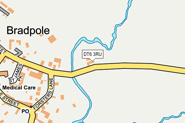
DT6 3RU is located in the Eggardon electoral ward, within the unitary authority of Dorset and the English Parliamentary constituency of West Dorset. The Sub Integrated Care Board (ICB) Location is NHS Dorset ICB - 11J and the police force is Dorset. This postcode has been in use since January 1980.


GetTheData
Source: OS OpenMap – Local (Ordnance Survey)
Source: OS VectorMap District (Ordnance Survey)
Licence: Open Government Licence (requires attribution)
| Easting | 348410 |
| Northing | 94304 |
| Latitude | 50.746026 |
| Longitude | -2.732582 |
GetTheData
Source: Open Postcode Geo
Licence: Open Government Licence
| Country | England |
| Postcode District | DT6 |
| ➜ DT6 open data dashboard ➜ See where DT6 is on a map ➜ Where is Bradpole? | |
GetTheData
Source: Land Registry Price Paid Data
Licence: Open Government Licence
Elevation or altitude of DT6 3RU as distance above sea level:
| Metres | Feet | |
|---|---|---|
| Elevation | 20m | 66ft |
Elevation is measured from the approximate centre of the postcode, to the nearest point on an OS contour line from OS Terrain 50, which has contour spacing of ten vertical metres.
➜ How high above sea level am I? Find the elevation of your current position using your device's GPS.
GetTheData
Source: Open Postcode Elevation
Licence: Open Government Licence
| Ward | Eggardon |
| Constituency | West Dorset |
GetTheData
Source: ONS Postcode Database
Licence: Open Government Licence
| June 2023 | Criminal damage and arson | On or near St James Park | 248m |
| February 2023 | Other theft | On or near Higher Street | 282m |
| June 2022 | Public order | On or near Middle Street | 316m |
| ➜ Get more crime data in our Crime section | |||
GetTheData
Source: data.police.uk
Licence: Open Government Licence
| St James Park (Higher Street) | Bradpole | 222m |
| St James Park (Higher Street) | Bradpole | 229m |
| Post Office (Forsters Lane) | Bradpole | 247m |
| Post Office (Middle Street) | Bradpole | 256m |
| Post Office (Middle Street) | Bradpole | 271m |
GetTheData
Source: NaPTAN
Licence: Open Government Licence
| Percentage of properties with Next Generation Access | 100.0% |
| Percentage of properties with Superfast Broadband | 100.0% |
| Percentage of properties with Ultrafast Broadband | 0.0% |
| Percentage of properties with Full Fibre Broadband | 0.0% |
Superfast Broadband is between 30Mbps and 300Mbps
Ultrafast Broadband is > 300Mbps
| Percentage of properties unable to receive 2Mbps | 0.0% |
| Percentage of properties unable to receive 5Mbps | 0.0% |
| Percentage of properties unable to receive 10Mbps | 0.0% |
| Percentage of properties unable to receive 30Mbps | 0.0% |
GetTheData
Source: Ofcom
Licence: Ofcom Terms of Use (requires attribution)
GetTheData
Source: ONS Postcode Database
Licence: Open Government Licence


➜ Get more ratings from the Food Standards Agency
GetTheData
Source: Food Standards Agency
Licence: FSA terms & conditions
| Last Collection | |||
|---|---|---|---|
| Location | Mon-Fri | Sat | Distance |
| Bradpole P.o. | 17:00 | 12:00 | 245m |
| Court Close | 16:45 | 12:00 | 669m |
| Loders | 09:00 | 09:00 | 959m |
GetTheData
Source: Dracos
Licence: Creative Commons Attribution-ShareAlike
| Facility | Distance |
|---|---|
| Bridport & West Dorset Indoor Bowls Club St. Andrews Trading Estate, Bridport Indoor Bowls | 825m |
| The Sir John Colfox Academy Ridgeway, Bridport Grass Pitches, Sports Hall, Artificial Grass Pitch, Health and Fitness Gym, Outdoor Tennis Courts | 1km |
| Bridport Primary School St. Andrews Road, Bridport Grass Pitches | 1.5km |
GetTheData
Source: Active Places
Licence: Open Government Licence
| School | Phase of Education | Distance |
|---|---|---|
| Loders CofE Primary Academy Loders, Bridport, DT6 3SA | Primary | 1km |
| The Sir John Colfox Academy Ridgeway, Bridport, DT6 3DT | Secondary | 1km |
| Bridport Primary School St Andrew's Road, Bridport, DT6 3BJ | Primary | 1.6km |
GetTheData
Source: Edubase
Licence: Open Government Licence
| Risk of DT6 3RU flooding from rivers and sea | Medium |
| ➜ DT6 3RU flood map | |
GetTheData
Source: Open Flood Risk by Postcode
Licence: Open Government Licence
The below table lists the International Territorial Level (ITL) codes (formerly Nomenclature of Territorial Units for Statistics (NUTS) codes) and Local Administrative Units (LAU) codes for DT6 3RU:
| ITL 1 Code | Name |
|---|---|
| TLK | South West (England) |
| ITL 2 Code | Name |
| TLK2 | Dorset and Somerset |
| ITL 3 Code | Name |
| TLK25 | Dorset |
| LAU 1 Code | Name |
| E06000059 | Dorset |
GetTheData
Source: ONS Postcode Directory
Licence: Open Government Licence
The below table lists the Census Output Area (OA), Lower Layer Super Output Area (LSOA), and Middle Layer Super Output Area (MSOA) for DT6 3RU:
| Code | Name | |
|---|---|---|
| OA | E00104115 | |
| LSOA | E01020531 | West Dorset 007C |
| MSOA | E02004275 | West Dorset 007 |
GetTheData
Source: ONS Postcode Directory
Licence: Open Government Licence
| DT6 3HY | Forsters Lane | 177m |
| DT6 3HZ | Bishops Farm Cottages | 193m |
| DT6 3UR | St James Park | 240m |
| DT6 3HX | Middle Street | 257m |
| DT6 3HU | Middle Street | 272m |
| DT6 3HT | Gordon Terrace | 292m |
| DT6 3HS | Middle Street | 310m |
| DT6 3JA | Higher Street | 341m |
| DT6 3JB | Newfoundland | 367m |
| DT6 3EP | Old School Houses | 388m |
GetTheData
Source: Open Postcode Geo; Land Registry Price Paid Data
Licence: Open Government Licence