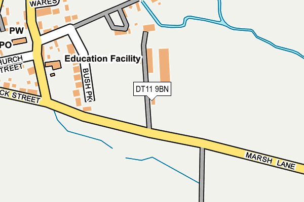
DT11 9BN is located in the Puddletown & Lower Winterborne electoral ward, within the unitary authority of Dorset and the English Parliamentary constituency of North Dorset. The Sub Integrated Care Board (ICB) Location is NHS Dorset ICB - 11J and the police force is Dorset. This postcode has been in use since January 1980.


GetTheData
Source: OS OpenMap – Local (Ordnance Survey)
Source: OS VectorMap District (Ordnance Survey)
Licence: Open Government Licence (requires attribution)
| Easting | 386480 |
| Northing | 97629 |
| Latitude | 50.778070 |
| Longitude | -2.193119 |
GetTheData
Source: Open Postcode Geo
Licence: Open Government Licence
| Country | England |
| Postcode District | DT11 |
| ➜ DT11 open data dashboard ➜ See where DT11 is on a map ➜ Where is Winterborne Kingston? | |
GetTheData
Source: Land Registry Price Paid Data
Licence: Open Government Licence
Elevation or altitude of DT11 9BN as distance above sea level:
| Metres | Feet | |
|---|---|---|
| Elevation | 60m | 197ft |
Elevation is measured from the approximate centre of the postcode, to the nearest point on an OS contour line from OS Terrain 50, which has contour spacing of ten vertical metres.
➜ How high above sea level am I? Find the elevation of your current position using your device's GPS.
GetTheData
Source: Open Postcode Elevation
Licence: Open Government Licence
| Ward | Puddletown & Lower Winterborne |
| Constituency | North Dorset |
GetTheData
Source: ONS Postcode Database
Licence: Open Government Licence
| February 2022 | Violence and sexual offences | On or near Clyppetts | 331m |
| February 2022 | Violence and sexual offences | On or near Clyppetts | 331m |
| November 2021 | Other theft | On or near North Street | 315m |
| ➜ Get more crime data in our Crime section | |||
GetTheData
Source: data.police.uk
Licence: Open Government Licence
| Dunbury School | Winterborne Kingston | 234m |
| Village Hall (North Street) | Winterborne Kingston | 296m |
| War Memorial | Winterborne Kingston | 311m |
| The Garage (West Street) | Winterborne Kingston | 315m |
| The Old Bakery (Duck Street) | Winterborne Kingston | 342m |
GetTheData
Source: NaPTAN
Licence: Open Government Licence
| Percentage of properties with Next Generation Access | 100.0% |
| Percentage of properties with Superfast Broadband | 100.0% |
| Percentage of properties with Ultrafast Broadband | 0.0% |
| Percentage of properties with Full Fibre Broadband | 0.0% |
Superfast Broadband is between 30Mbps and 300Mbps
Ultrafast Broadband is > 300Mbps
| Percentage of properties unable to receive 2Mbps | 0.0% |
| Percentage of properties unable to receive 5Mbps | 0.0% |
| Percentage of properties unable to receive 10Mbps | 0.0% |
| Percentage of properties unable to receive 30Mbps | 0.0% |
GetTheData
Source: Ofcom
Licence: Ofcom Terms of Use (requires attribution)
GetTheData
Source: ONS Postcode Database
Licence: Open Government Licence


➜ Get more ratings from the Food Standards Agency
GetTheData
Source: Food Standards Agency
Licence: FSA terms & conditions
| Last Collection | |||
|---|---|---|---|
| Location | Mon-Fri | Sat | Distance |
| Winterborne King P.o. | 16:00 | 09:15 | 325m |
| Winterborne Muston | 12:00 | 10:00 | 743m |
| St Marys Rectory | 10:30 | 10:30 | 1,581m |
GetTheData
Source: Dracos
Licence: Creative Commons Attribution-ShareAlike
| Facility | Distance |
|---|---|
| Bere Regis Sports Club North Street, Bere Regis, Wareham Grass Pitches | 2.9km |
| Morden Recreation Ground And Village Hall Morden, Wareham Grass Pitches, Outdoor Tennis Courts | 5.4km |
GetTheData
Source: Active Places
Licence: Open Government Licence
| School | Phase of Education | Distance |
|---|---|---|
| Bere Regis Primary and Preschool Southbrook, Bere Regis, Wareham, BH20 7DB | Primary | 3.7km |
| Dunbury Church of England Academy Dolway Lane, Blandford Forum, Winterborne Whitechurch, DT11 0AW | Primary | 3.9km |
| The Luccombe Hub Unit 12, East Luccombe Farm, Milton Abbas, Blandford Forum, DT11 0BD | Not applicable | 6km |
GetTheData
Source: Edubase
Licence: Open Government Licence
| Risk of DT11 9BN flooding from rivers and sea | Medium |
| ➜ DT11 9BN flood map | |
GetTheData
Source: Open Flood Risk by Postcode
Licence: Open Government Licence
The below table lists the International Territorial Level (ITL) codes (formerly Nomenclature of Territorial Units for Statistics (NUTS) codes) and Local Administrative Units (LAU) codes for DT11 9BN:
| ITL 1 Code | Name |
|---|---|
| TLK | South West (England) |
| ITL 2 Code | Name |
| TLK2 | Dorset and Somerset |
| ITL 3 Code | Name |
| TLK25 | Dorset |
| LAU 1 Code | Name |
| E06000059 | Dorset |
GetTheData
Source: ONS Postcode Directory
Licence: Open Government Licence
The below table lists the Census Output Area (OA), Lower Layer Super Output Area (LSOA), and Middle Layer Super Output Area (MSOA) for DT11 9BN:
| Code | Name | |
|---|---|---|
| OA | E00103535 | |
| LSOA | E01020432 | North Dorset 008C |
| MSOA | E02004262 | North Dorset 008 |
GetTheData
Source: ONS Postcode Directory
Licence: Open Government Licence
| DT11 9BQ | East Street | 60m |
| DT11 9BS | Wares Close | 174m |
| DT11 9BG | Bush Park | 174m |
| DT11 9BJ | Sackville Street | 216m |
| DT11 9BW | Duck Street | 261m |
| DT11 9BZ | Pitcher Close | 277m |
| DT11 9BE | Church Lane | 285m |
| DT11 9QE | Church Street | 289m |
| DT11 9BL | Broad Close | 304m |
| DT11 9BA | Bere Road | 333m |
GetTheData
Source: Open Postcode Geo; Land Registry Price Paid Data
Licence: Open Government Licence