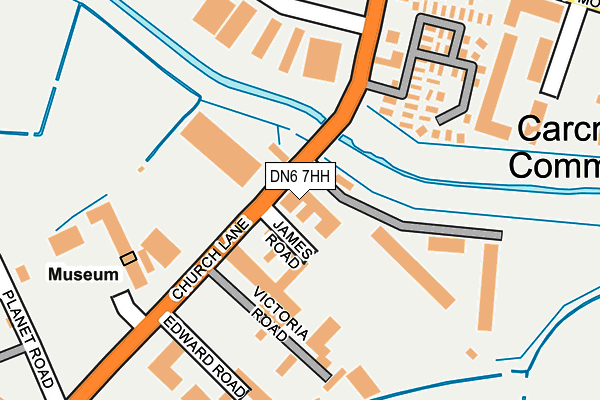
DN6 7HH lies on James Road in Adwick Le Street, Doncaster. DN6 7HH is located in the Adwick le Street & Carcroft electoral ward, within the metropolitan district of Doncaster and the English Parliamentary constituency of Doncaster North. The Sub Integrated Care Board (ICB) Location is NHS South Yorkshire ICB - 02X and the police force is South Yorkshire. This postcode has been in use since December 1996.


GetTheData
Source: OS OpenMap – Local (Ordnance Survey)
Source: OS VectorMap District (Ordnance Survey)
Licence: Open Government Licence (requires attribution)
| Easting | 454608 |
| Northing | 409014 |
| Latitude | 53.574912 |
| Longitude | -1.176790 |
GetTheData
Source: Open Postcode Geo
Licence: Open Government Licence
| Street | James Road |
| Locality | Adwick Le Street |
| Town/City | Doncaster |
| Country | England |
| Postcode District | DN6 |
| ➜ DN6 open data dashboard ➜ See where DN6 is on a map ➜ Where is Adwick le Street? | |
GetTheData
Source: Land Registry Price Paid Data
Licence: Open Government Licence
Elevation or altitude of DN6 7HH as distance above sea level:
| Metres | Feet | |
|---|---|---|
| Elevation | 10m | 33ft |
Elevation is measured from the approximate centre of the postcode, to the nearest point on an OS contour line from OS Terrain 50, which has contour spacing of ten vertical metres.
➜ How high above sea level am I? Find the elevation of your current position using your device's GPS.
GetTheData
Source: Open Postcode Elevation
Licence: Open Government Licence
| Ward | Adwick Le Street & Carcroft |
| Constituency | Doncaster North |
GetTheData
Source: ONS Postcode Database
Licence: Open Government Licence
F P E LTD, JAMES ROAD, ADWICK LE STREET, DONCASTER, DN6 7HH 2008 22 AUG £175,000 |
➜ Adwick le Street house prices
GetTheData
Source: HM Land Registry Price Paid Data
Licence: Contains HM Land Registry data © Crown copyright and database right 2024. This data is licensed under the Open Government Licence v3.0.
| June 2022 | Other theft | On or near Edward Road | 119m |
| June 2022 | Vehicle crime | On or near Petrol Station | 235m |
| June 2022 | Vehicle crime | On or near Brooklands Road | 311m |
| ➜ Get more crime data in our Crime section | |||
GetTheData
Source: data.police.uk
Licence: Open Government Licence
| Victoria Road (Church Lane) | Adwick Le Street | 106m |
| Victoria Road (Church Lane) | Adwick Le Street | 184m |
| Bentley Moor Lane (Station Road) | Adwick Le Street | 266m |
| Brooklands Road (Station Road) | Adwick Le Street | 285m |
| Adwick Station (Adwick Lane) | Adwick Le Street | 365m |
| Adwick Station | 0.4km |
| Bentley (S Yorks) Station | 3.8km |
GetTheData
Source: NaPTAN
Licence: Open Government Licence
GetTheData
Source: ONS Postcode Database
Licence: Open Government Licence


➜ Get more ratings from the Food Standards Agency
GetTheData
Source: Food Standards Agency
Licence: FSA terms & conditions
| Last Collection | |||
|---|---|---|---|
| Location | Mon-Fri | Sat | Distance |
| Brooklands Road | 17:00 | 09:30 | 235m |
| Adwick Post Office | 17:00 | 11:00 | 682m |
| Carcroft Post Office | 17:00 | 10:45 | 932m |
GetTheData
Source: Dracos
Licence: Creative Commons Attribution-ShareAlike
| Facility | Distance |
|---|---|
| World Fitness Victoria Road, Adwick-le-street, Doncaster Health and Fitness Gym, Studio | 98m |
| Adwick Lane Playing Field Adwick Lane, Adwick Le Street, Doncaster Grass Pitches | 242m |
| Adwick Park Windmill Balk Lane, Adwick-le-street, Doncaster Grass Pitches | 894m |
GetTheData
Source: Active Places
Licence: Open Government Licence
| School | Phase of Education | Distance |
|---|---|---|
| Carcroft Primary School Owston Road, Carcroft, Doncaster, DN6 8DR | Primary | 1.1km |
| Outwood Academy Adwick Windmill Balk Lane, Woodlands, Doncaster, DN6 7SF | Secondary | 1.3km |
| Adwick Primary School Stafford Road, Woodlands, Doncaster, DN6 7LW | Primary | 1.3km |
GetTheData
Source: Edubase
Licence: Open Government Licence
| Risk of DN6 7HH flooding from rivers and sea | Low |
| ➜ DN6 7HH flood map | |
GetTheData
Source: Open Flood Risk by Postcode
Licence: Open Government Licence
The below table lists the International Territorial Level (ITL) codes (formerly Nomenclature of Territorial Units for Statistics (NUTS) codes) and Local Administrative Units (LAU) codes for DN6 7HH:
| ITL 1 Code | Name |
|---|---|
| TLE | Yorkshire and The Humber |
| ITL 2 Code | Name |
| TLE3 | South Yorkshire |
| ITL 3 Code | Name |
| TLE31 | Barnsley, Doncaster and Rotherham |
| LAU 1 Code | Name |
| E08000017 | Doncaster |
GetTheData
Source: ONS Postcode Directory
Licence: Open Government Licence
The below table lists the Census Output Area (OA), Lower Layer Super Output Area (LSOA), and Middle Layer Super Output Area (MSOA) for DN6 7HH:
| Code | Name | |
|---|---|---|
| OA | E00038035 | |
| LSOA | E01007504 | Doncaster 009F |
| MSOA | E02001547 | Doncaster 009 |
GetTheData
Source: ONS Postcode Directory
Licence: Open Government Licence
| DN6 7AQ | Church Lane | 576m |
| DN6 7HE | The Paddock | 610m |
| DN6 7AH | St Lawrences Terrace | 628m |
| DN6 7AP | Farm Court | 633m |
| DN6 7AG | Mill Lane | 653m |
| DN6 7HF | Meadow Court | 660m |
| DN6 7UN | Osprey Close | 679m |
| DN6 8DB | Station Road | 683m |
| DN6 7AA | Village Street | 690m |
| DN6 8DE | Askern Road | 706m |
GetTheData
Source: Open Postcode Geo; Land Registry Price Paid Data
Licence: Open Government Licence