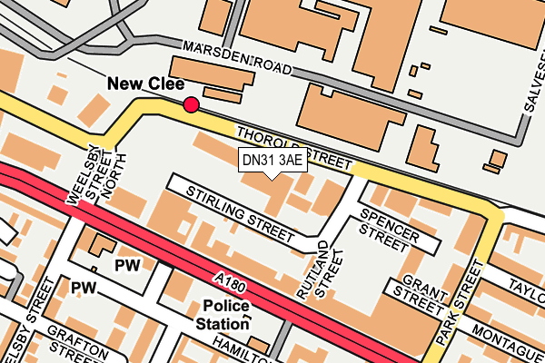
DN31 3AE lies on Stirling Street in Grimsby. DN31 3AE is located in the East Marsh electoral ward, within the unitary authority of North East Lincolnshire and the English Parliamentary constituency of Great Grimsby. The Sub Integrated Care Board (ICB) Location is NHS Humber and North Yorkshire ICB - 03H and the police force is Humberside. This postcode has been in use since January 1980.


GetTheData
Source: OS OpenMap – Local (Ordnance Survey)
Source: OS VectorMap District (Ordnance Survey)
Licence: Open Government Licence (requires attribution)
| Easting | 528646 |
| Northing | 410272 |
| Latitude | 53.573306 |
| Longitude | -0.058663 |
GetTheData
Source: Open Postcode Geo
Licence: Open Government Licence
| Street | Stirling Street |
| Town/City | Grimsby |
| Country | England |
| Postcode District | DN31 |
| ➜ DN31 open data dashboard ➜ See where DN31 is on a map ➜ Where is Grimsby? | |
GetTheData
Source: Land Registry Price Paid Data
Licence: Open Government Licence
Elevation or altitude of DN31 3AE as distance above sea level:
| Metres | Feet | |
|---|---|---|
| Elevation | 10m | 33ft |
Elevation is measured from the approximate centre of the postcode, to the nearest point on an OS contour line from OS Terrain 50, which has contour spacing of ten vertical metres.
➜ How high above sea level am I? Find the elevation of your current position using your device's GPS.
GetTheData
Source: Open Postcode Elevation
Licence: Open Government Licence
| Ward | East Marsh |
| Constituency | Great Grimsby |
GetTheData
Source: ONS Postcode Database
Licence: Open Government Licence
| January 2024 | Public order | On or near Sidney Way | 365m |
| January 2024 | Anti-social behaviour | On or near Hilda Street | 435m |
| January 2024 | Criminal damage and arson | On or near Hilda Street | 435m |
| ➜ Stirling Street crime map and outcomes | |||
GetTheData
Source: data.police.uk
Licence: Open Government Licence
| Ramsdens (Cleethorpe Road) | East Marsh | 134m |
| Weelsby Street (Cleethorpe Road) | East Marsh | 135m |
| Ramsdens (Cleethorpe Road) | East Marsh | 144m |
| Weelsby Street (Cleethorpe Road) | East Marsh | 213m |
| Park Street (Grimsby Road) | Cleethorpes | 295m |
| New Clee Station | 0.2km |
| Grimsby Docks Station | 1.1km |
| Grimsby Town Station | 2.2km |
GetTheData
Source: NaPTAN
Licence: Open Government Licence
GetTheData
Source: ONS Postcode Database
Licence: Open Government Licence


➜ Get more ratings from the Food Standards Agency
GetTheData
Source: Food Standards Agency
Licence: FSA terms & conditions
| Last Collection | |||
|---|---|---|---|
| Location | Mon-Fri | Sat | Distance |
| Oxford Street | 18:30 | 11:45 | 367m |
| Wickham Road | 17:00 | 11:30 | 423m |
| Cleethorpe Road | 18:30 | 12:30 | 508m |
GetTheData
Source: Dracos
Licence: Creative Commons Attribution-ShareAlike
| Facility | Distance |
|---|---|
| Spartana Health Studio (Closed) Cleethorpe Road, Grimsby Health and Fitness Gym | 103m |
| Weelsby Academy Weelsby Street, Grimsby Grass Pitches | 568m |
| Oasis Health Club (Grimsby) Orwell Street, Grimsby Health and Fitness Gym, Swimming Pool, Studio | 806m |
GetTheData
Source: Active Places
Licence: Open Government Licence
| School | Phase of Education | Distance |
|---|---|---|
| Weelsby Academy Weelsby Street, Grimsby, DN32 7PF | Primary | 610m |
| Phoenix Park Academy Harold Street, Grimsby, DN32 7NQ | Not applicable | 657m |
| Strand Primary Academy Strand Street, Grimsby, DN32 7BE | Primary | 674m |
GetTheData
Source: Edubase
Licence: Open Government Licence
| Risk of DN31 3AE flooding from rivers and sea | Very Low |
| ➜ DN31 3AE flood map | |
GetTheData
Source: Open Flood Risk by Postcode
Licence: Open Government Licence
The below table lists the International Territorial Level (ITL) codes (formerly Nomenclature of Territorial Units for Statistics (NUTS) codes) and Local Administrative Units (LAU) codes for DN31 3AE:
| ITL 1 Code | Name |
|---|---|
| TLE | Yorkshire and The Humber |
| ITL 2 Code | Name |
| TLE1 | East Yorkshire and Northern Lincolnshire |
| ITL 3 Code | Name |
| TLE13 | North and North East Lincolnshire |
| LAU 1 Code | Name |
| E06000012 | North East Lincolnshire |
GetTheData
Source: ONS Postcode Directory
Licence: Open Government Licence
The below table lists the Census Output Area (OA), Lower Layer Super Output Area (LSOA), and Middle Layer Super Output Area (MSOA) for DN31 3AE:
| Code | Name | |
|---|---|---|
| OA | E00066296 | |
| LSOA | E01013136 | North East Lincolnshire 002A |
| MSOA | E02002727 | North East Lincolnshire 002 |
GetTheData
Source: ONS Postcode Directory
Licence: Open Government Licence
| DN31 3AF | Rutland Street | 63m |
| DN31 3BP | Cleethorpe Road | 85m |
| DN31 3BU | Cleethorpe Road | 128m |
| DN32 7RH | Hamilton Street | 195m |
| DN32 7QZ | Hamilton Street | 204m |
| DN32 7RF | Stanley Street | 240m |
| DN32 7RR | Grafton Street | 247m |
| DN32 7RP | Grafton Street | 258m |
| DN32 7RW | Grafton Street | 278m |
| DN32 7RS | Rutland Street | 283m |
GetTheData
Source: Open Postcode Geo; Land Registry Price Paid Data
Licence: Open Government Licence