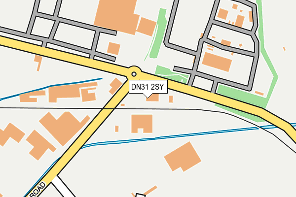
DN31 2SY is located in the Freshney electoral ward, within the unitary authority of North East Lincolnshire and the English Parliamentary constituency of Great Grimsby. The Sub Integrated Care Board (ICB) Location is NHS Humber and North Yorkshire ICB - 03H and the police force is Humberside. This postcode has been in use since February 1984.


GetTheData
Source: OS OpenMap – Local (Ordnance Survey)
Source: OS VectorMap District (Ordnance Survey)
Licence: Open Government Licence (requires attribution)
| Easting | 525102 |
| Northing | 411135 |
| Latitude | 53.581914 |
| Longitude | -0.111806 |
GetTheData
Source: Open Postcode Geo
Licence: Open Government Licence
| Country | England |
| Postcode District | DN31 |
| ➜ DN31 open data dashboard ➜ See where DN31 is on a map ➜ Where is Grimsby? | |
GetTheData
Source: Land Registry Price Paid Data
Licence: Open Government Licence
Elevation or altitude of DN31 2SY as distance above sea level:
| Metres | Feet | |
|---|---|---|
| Elevation | 10m | 33ft |
Elevation is measured from the approximate centre of the postcode, to the nearest point on an OS contour line from OS Terrain 50, which has contour spacing of ten vertical metres.
➜ How high above sea level am I? Find the elevation of your current position using your device's GPS.
GetTheData
Source: Open Postcode Elevation
Licence: Open Government Licence
| Ward | Freshney |
| Constituency | Great Grimsby |
GetTheData
Source: ONS Postcode Database
Licence: Open Government Licence
| May 2022 | Vehicle crime | On or near Estate Road No 4 | 381m |
| May 2022 | Violence and sexual offences | On or near Appian Way | 436m |
| May 2022 | Criminal damage and arson | On or near Appian Way | 436m |
| ➜ Get more crime data in our Crime section | |||
GetTheData
Source: data.police.uk
Licence: Open Government Licence
| Moody Lane | Pyewipe | 127m |
| Moody Lane | Pyewipe | 167m |
| Cavaghan & Gray (Estate Road No 1) | Pyewipe | 372m |
| Novartis (Moody Lane) | Pyewipe | 467m |
| Tioxide (Moody Lane) | Pyewipe | 523m |
| Great Coates Station | 1.4km |
| Grimsby Docks Station | 2.5km |
| Grimsby Town Station | 2.6km |
GetTheData
Source: NaPTAN
Licence: Open Government Licence
GetTheData
Source: ONS Postcode Database
Licence: Open Government Licence


➜ Get more ratings from the Food Standards Agency
GetTheData
Source: Food Standards Agency
Licence: FSA terms & conditions
| Last Collection | |||
|---|---|---|---|
| Location | Mon-Fri | Sat | Distance |
| Estate Road 2 Business Box | 17:30 | 557m | |
| South Humberside | 17:30 | 11:15 | 557m |
| South Humberside Ind. Estate | 17:30 | 11:00 | 763m |
GetTheData
Source: Dracos
Licence: Creative Commons Attribution-ShareAlike
| Facility | Distance |
|---|---|
| Dunlop Oil And Marine Ltd Moody Lane, Grimsby Grass Pitches | 0m |
| Tioxide Europe Sports Ground (Closed) Moody Lane, Grimsby Grass Pitches | 338m |
| Novartis Grimsby Sport & Social Club Pyewipe, Grimsby Grass Pitches, Artificial Grass Pitch | 419m |
GetTheData
Source: Active Places
Licence: Open Government Licence
| School | Phase of Education | Distance |
|---|---|---|
| The Orchard Independent Special School Unit 1, Sargon Way, Great Grimsby Business Park, Grimsby, DN37 9PH | Not applicable | 591m |
| Littlecoates Primary Academy Harlow Street, Grimsby, DN31 2QX | Primary | 1km |
| Macaulay Primary Academy Macaulay Street, Grimsby, DN31 2ES | Primary | 1.7km |
GetTheData
Source: Edubase
Licence: Open Government Licence
| Risk of DN31 2SY flooding from rivers and sea | Very Low |
| ➜ DN31 2SY flood map | |
GetTheData
Source: Open Flood Risk by Postcode
Licence: Open Government Licence
The below table lists the International Territorial Level (ITL) codes (formerly Nomenclature of Territorial Units for Statistics (NUTS) codes) and Local Administrative Units (LAU) codes for DN31 2SY:
| ITL 1 Code | Name |
|---|---|
| TLE | Yorkshire and The Humber |
| ITL 2 Code | Name |
| TLE1 | East Yorkshire and Northern Lincolnshire |
| ITL 3 Code | Name |
| TLE13 | North and North East Lincolnshire |
| LAU 1 Code | Name |
| E06000012 | North East Lincolnshire |
GetTheData
Source: ONS Postcode Directory
Licence: Open Government Licence
The below table lists the Census Output Area (OA), Lower Layer Super Output Area (LSOA), and Middle Layer Super Output Area (MSOA) for DN31 2SY:
| Code | Name | |
|---|---|---|
| OA | E00066363 | |
| LSOA | E01013146 | North East Lincolnshire 004C |
| MSOA | E02002729 | North East Lincolnshire 004 |
GetTheData
Source: ONS Postcode Directory
Licence: Open Government Licence
| DN31 2TB | 274m | |
| DN31 2FD | Europa Park | 312m |
| DN31 2TX | Estate Road 5 | 474m |
| DN31 2UW | Venture Business Park | 606m |
| DN37 9FB | Navensby Close | 780m |
| DN31 2TG | 843m | |
| DN31 2UA | Haven Gardens | 849m |
| DN37 9FD | Sibsey Court | 874m |
| DN37 9ND | Woad Lane | 906m |
| DN31 2SU | West Coates Road | 915m |
GetTheData
Source: Open Postcode Geo; Land Registry Price Paid Data
Licence: Open Government Licence