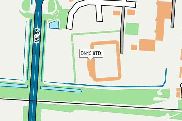
DN15 8TD is located in the Burringham & Gunness electoral ward, within the unitary authority of North Lincolnshire and the English Parliamentary constituency of Brigg and Goole. The Sub Integrated Care Board (ICB) Location is NHS Humber and North Yorkshire ICB - 03K and the police force is Humberside. This postcode has been in use since February 1990.


GetTheData
Source: OS OpenMap – Local (Ordnance Survey)
Source: OS VectorMap District (Ordnance Survey)
Licence: Open Government Licence (requires attribution)
| Easting | 486421 |
| Northing | 410803 |
| Latitude | 53.586699 |
| Longitude | -0.695968 |
GetTheData
Source: Open Postcode Geo
Licence: Open Government Licence
| Country | England |
| Postcode District | DN15 |
| ➜ DN15 open data dashboard ➜ See where DN15 is on a map ➜ Where is Scunthorpe? | |
GetTheData
Source: Land Registry Price Paid Data
Licence: Open Government Licence
Elevation or altitude of DN15 8TD as distance above sea level:
| Metres | Feet | |
|---|---|---|
| Elevation | 10m | 33ft |
Elevation is measured from the approximate centre of the postcode, to the nearest point on an OS contour line from OS Terrain 50, which has contour spacing of ten vertical metres.
➜ How high above sea level am I? Find the elevation of your current position using your device's GPS.
GetTheData
Source: Open Postcode Elevation
Licence: Open Government Licence
| Ward | Burringham & Gunness |
| Constituency | Brigg And Goole |
GetTheData
Source: ONS Postcode Database
Licence: Open Government Licence
| June 2022 | Violence and sexual offences | On or near Sports/Recreation Area | 43m |
| June 2022 | Other theft | On or near Sports/Recreation Area | 43m |
| June 2022 | Criminal damage and arson | On or near M181 | 181m |
| ➜ Get more crime data in our Crime section | |||
GetTheData
Source: data.police.uk
Licence: Open Government Licence
| United Football Ground (Doncaster Road) | Scunthorpe | 130m |
| Gallagher Retail Park (Doncaster Road) | Scunthorpe | 278m |
| Gallagher Retail Park (Doncaster Road) | Scunthorpe | 360m |
| Tesco (Doncaster Road) | Scunthorpe | 373m |
| Minster Road Day Centre (Bolsover Road) | Scunthorpe | 484m |
| Althorpe Station | 2.5km |
| Scunthorpe Station | 3km |
GetTheData
Source: NaPTAN
Licence: Open Government Licence
GetTheData
Source: ONS Postcode Database
Licence: Open Government Licence


➜ Get more ratings from the Food Standards Agency
GetTheData
Source: Food Standards Agency
Licence: FSA terms & conditions
| Last Collection | |||
|---|---|---|---|
| Location | Mon-Fri | Sat | Distance |
| Tesco Scunthorpe | 17:15 | 12:00 | 361m |
| Scotter Road P.o. | 17:30 | 12:00 | 788m |
| Scotter Road | 17:30 | 12:00 | 992m |
GetTheData
Source: Dracos
Licence: Creative Commons Attribution-ShareAlike
| Facility | Distance |
|---|---|
| Scunthorpe United Fc (Glanford Park) Doncaster Road, Scunthorpe Grass Pitches | 47m |
| Scunthorpe United Fc Training Ground Doncaster Road, Scunthorpe Grass Pitches | 109m |
| Scunthorpe Sports Club Herriot Walk, Scunthorpe Sports Hall | 931m |
GetTheData
Source: Active Places
Licence: Open Government Licence
| School | Phase of Education | Distance |
|---|---|---|
| Oasis Academy Parkwood Plymouth Road, Scunthorpe, DN17 1SS | Primary | 1.4km |
| Berkeley Primary School Marsden Drive, Scunthorpe, DN15 8AH | Primary | 1.4km |
| Skills Centre PLUS Suite 4 Woodfield House, Berkeley Business Centre, Doncaster Road, Scunthorpe, DN15 7DQ | Not applicable | 1.6km |
GetTheData
Source: Edubase
Licence: Open Government Licence
| Risk of DN15 8TD flooding from rivers and sea | Medium |
| ➜ DN15 8TD flood map | |
GetTheData
Source: Open Flood Risk by Postcode
Licence: Open Government Licence
The below table lists the International Territorial Level (ITL) codes (formerly Nomenclature of Territorial Units for Statistics (NUTS) codes) and Local Administrative Units (LAU) codes for DN15 8TD:
| ITL 1 Code | Name |
|---|---|
| TLE | Yorkshire and The Humber |
| ITL 2 Code | Name |
| TLE1 | East Yorkshire and Northern Lincolnshire |
| ITL 3 Code | Name |
| TLE13 | North and North East Lincolnshire |
| LAU 1 Code | Name |
| E06000013 | North Lincolnshire |
GetTheData
Source: ONS Postcode Directory
Licence: Open Government Licence
The below table lists the Census Output Area (OA), Lower Layer Super Output Area (LSOA), and Middle Layer Super Output Area (MSOA) for DN15 8TD:
| Code | Name | |
|---|---|---|
| OA | E00067053 | |
| LSOA | E01013286 | North Lincolnshire 005A |
| MSOA | E02002753 | North Lincolnshire 005 |
GetTheData
Source: ONS Postcode Directory
Licence: Open Government Licence
| DN15 8JH | North Lincolnshire Shopping Park | 242m |
| DN15 8TE | Doncaster Road | 265m |
| DN15 7UL | Matlock Court | 298m |
| DN15 7UJ | Ripley Court | 299m |
| DN15 7UH | Tideswell Court | 341m |
| DN15 7UF | Buxton Court | 344m |
| DN15 7UN | Derby Road | 353m |
| DN15 7UE | Heanor Court | 367m |
| DN15 7UP | Chesterfield Road | 379m |
| DN15 7UA | Bakewell Court | 388m |
GetTheData
Source: Open Postcode Geo; Land Registry Price Paid Data
Licence: Open Government Licence