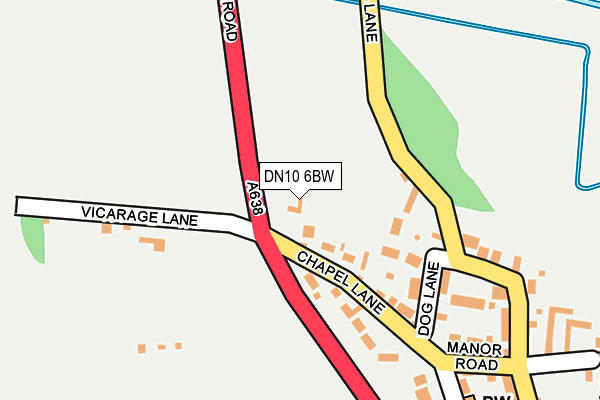
DN10 6BW lies on Great North Road in Scrooby, Doncaster. DN10 6BW is located in the Blyth electoral ward, within the local authority district of Bassetlaw and the English Parliamentary constituency of Bassetlaw. The Sub Integrated Care Board (ICB) Location is NHS Nottingham and Nottinghamshire ICB - 02Q and the police force is Nottinghamshire. This postcode has been in use since January 1980.


GetTheData
Source: OS OpenMap – Local (Ordnance Survey)
Source: OS VectorMap District (Ordnance Survey)
Licence: Open Government Licence (requires attribution)
| Easting | 465006 |
| Northing | 391007 |
| Latitude | 53.411878 |
| Longitude | -1.023505 |
GetTheData
Source: Open Postcode Geo
Licence: Open Government Licence
| Street | Great North Road |
| Locality | Scrooby |
| Town/City | Doncaster |
| Country | England |
| Postcode District | DN10 |
| ➜ DN10 open data dashboard ➜ See where DN10 is on a map ➜ Where is Scrooby? | |
GetTheData
Source: Land Registry Price Paid Data
Licence: Open Government Licence
Elevation or altitude of DN10 6BW as distance above sea level:
| Metres | Feet | |
|---|---|---|
| Elevation | 10m | 33ft |
Elevation is measured from the approximate centre of the postcode, to the nearest point on an OS contour line from OS Terrain 50, which has contour spacing of ten vertical metres.
➜ How high above sea level am I? Find the elevation of your current position using your device's GPS.
GetTheData
Source: Open Postcode Elevation
Licence: Open Government Licence
| Ward | Blyth |
| Constituency | Bassetlaw |
GetTheData
Source: ONS Postcode Database
Licence: Open Government Licence
2015 10 DEC £400,000 |
2000 21 JAN £168,000 |
GetTheData
Source: HM Land Registry Price Paid Data
Licence: Contains HM Land Registry data © Crown copyright and database right 2024. This data is licensed under the Open Government Licence v3.0.
| June 2022 | Burglary | On or near Chapel Lane | 107m |
| September 2021 | Violence and sexual offences | On or near Chapel Lane | 107m |
| August 2021 | Violence and sexual offences | On or near Church Lane | 287m |
| ➜ Get more crime data in our Crime section | |||
GetTheData
Source: data.police.uk
Licence: Open Government Licence
| Pilgrim Fathers (Great North Road) | Scrooby | 246m |
| Pilgrim Fathers (Great North Road) | Scrooby | 304m |
| Mill Lane (Great North Road) | Gibbet Hill | 544m |
| Mill Lane (Great North Road) | Gibbet Hill | 560m |
| Pilgrims Oak (Great North Road) | Scrooby | 637m |
GetTheData
Source: NaPTAN
Licence: Open Government Licence
GetTheData
Source: ONS Postcode Database
Licence: Open Government Licence


➜ Get more ratings from the Food Standards Agency
GetTheData
Source: Food Standards Agency
Licence: FSA terms & conditions
| Last Collection | |||
|---|---|---|---|
| Location | Mon-Fri | Sat | Distance |
| Scrooby Post Office | 17:00 | 07:30 | 357m |
| Gibbet Hill Caravan Park | 17:30 | 09:15 | 787m |
| Scaftworth | 17:45 | 09:00 | 1,614m |
GetTheData
Source: Dracos
Licence: Creative Commons Attribution-ShareAlike
| Facility | Distance |
|---|---|
| Bawtry Memorial Sports Ground Great North Road, Bawtry, Doncaster Grass Pitches | 1.6km |
| Harworth Bmx Track (Closed) Scrooby Road, Harworth, Doncaster Cycling | 1.9km |
| Bawtry Gym Church Walk, Bawtry, Doncaster Health and Fitness Gym | 2km |
GetTheData
Source: Active Places
Licence: Open Government Licence
| School | Phase of Education | Distance |
|---|---|---|
| Serlby Park Academy Whitehouse Road, Bircotes, Doncaster, DN11 8EF | All-through | 2.3km |
| St Patrick's Catholic Primary School Whitehouse Road, Bircotes, Doncaster, DN11 8EF | Primary | 2.3km |
| Bawtry Mayflower Primary School Station Road, Bawtry, Doncaster, DN10 6PU | Primary | 2.5km |
GetTheData
Source: Edubase
Licence: Open Government Licence
The below table lists the International Territorial Level (ITL) codes (formerly Nomenclature of Territorial Units for Statistics (NUTS) codes) and Local Administrative Units (LAU) codes for DN10 6BW:
| ITL 1 Code | Name |
|---|---|
| TLF | East Midlands (England) |
| ITL 2 Code | Name |
| TLF1 | Derbyshire and Nottinghamshire |
| ITL 3 Code | Name |
| TLF15 | North Nottinghamshire |
| LAU 1 Code | Name |
| E07000171 | Bassetlaw |
GetTheData
Source: ONS Postcode Directory
Licence: Open Government Licence
The below table lists the Census Output Area (OA), Lower Layer Super Output Area (LSOA), and Middle Layer Super Output Area (MSOA) for DN10 6BW:
| Code | Name | |
|---|---|---|
| OA | E00142664 | |
| LSOA | E01028000 | Bassetlaw 001A |
| MSOA | E02005835 | Bassetlaw 001 |
GetTheData
Source: ONS Postcode Directory
Licence: Open Government Licence
| DN10 6AQ | Mill Lane | 111m |
| DN10 6AF | Dog Lane | 142m |
| DN10 6AE | Chapel Lane | 151m |
| DN10 6BS | Holmefield Croft | 185m |
| DN10 6AG | Low Road | 223m |
| DN10 6AD | Vicarage Lane | 248m |
| DN10 6AH | Manor Road | 294m |
| DN10 6AR | Church Lane | 297m |
| DN10 6AS | Saracens Lane | 325m |
| DN10 6AL | Station Road | 370m |
GetTheData
Source: Open Postcode Geo; Land Registry Price Paid Data
Licence: Open Government Licence