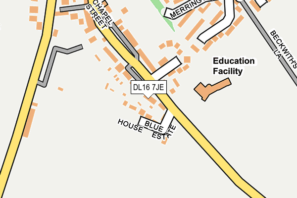
DL16 7JE is located in the Ferryhill electoral ward, within the unitary authority of County Durham and the English Parliamentary constituency of Bishop Auckland. The Sub Integrated Care Board (ICB) Location is NHS North East and North Cumbria ICB - 84H and the police force is Durham. This postcode has been in use since January 1980.


GetTheData
Source: OS OpenMap – Local (Ordnance Survey)
Source: OS VectorMap District (Ordnance Survey)
Licence: Open Government Licence (requires attribution)
| Easting | 426170 |
| Northing | 531073 |
| Latitude | 54.674050 |
| Longitude | -1.595705 |
GetTheData
Source: Open Postcode Geo
Licence: Open Government Licence
| Country | England |
| Postcode District | DL16 |
| ➜ DL16 open data dashboard ➜ See where DL16 is on a map ➜ Where is Kirk Merrington? | |
GetTheData
Source: Land Registry Price Paid Data
Licence: Open Government Licence
Elevation or altitude of DL16 7JE as distance above sea level:
| Metres | Feet | |
|---|---|---|
| Elevation | 180m | 591ft |
Elevation is measured from the approximate centre of the postcode, to the nearest point on an OS contour line from OS Terrain 50, which has contour spacing of ten vertical metres.
➜ How high above sea level am I? Find the elevation of your current position using your device's GPS.
GetTheData
Source: Open Postcode Elevation
Licence: Open Government Licence
| Ward | Ferryhill |
| Constituency | Bishop Auckland |
GetTheData
Source: ONS Postcode Database
Licence: Open Government Licence
| June 2022 | Anti-social behaviour | On or near Kirkstone Close | 60m |
| June 2022 | Violence and sexual offences | On or near Merrington Close | 213m |
| June 2022 | Other theft | On or near Hallgarth | 361m |
| ➜ Get more crime data in our Crime section | |||
GetTheData
Source: data.police.uk
Licence: Open Government Licence
| Schools (Unclassified Road To Chilton) | Kirk Merrington | 48m |
| Schools (Unclassified Road To Chilton) | Kirk Merrington | 69m |
| Eden Terrace (Unclassified Road To Leasingthorne) | Kirk Merrington | 264m |
| Eden Terrace (Unclassified Road To Leasingthorne) | Kirk Merrington | 269m |
| Green (Unclassified Road Opposite Half Moon Inn) | Kirk Merrington | 318m |
GetTheData
Source: NaPTAN
Licence: Open Government Licence
| Percentage of properties with Next Generation Access | 100.0% |
| Percentage of properties with Superfast Broadband | 100.0% |
| Percentage of properties with Ultrafast Broadband | 0.0% |
| Percentage of properties with Full Fibre Broadband | 0.0% |
Superfast Broadband is between 30Mbps and 300Mbps
Ultrafast Broadband is > 300Mbps
| Percentage of properties unable to receive 2Mbps | 0.0% |
| Percentage of properties unable to receive 5Mbps | 0.0% |
| Percentage of properties unable to receive 10Mbps | 0.0% |
| Percentage of properties unable to receive 30Mbps | 0.0% |
GetTheData
Source: Ofcom
Licence: Ofcom Terms of Use (requires attribution)
GetTheData
Source: ONS Postcode Database
Licence: Open Government Licence


➜ Get more ratings from the Food Standards Agency
GetTheData
Source: Food Standards Agency
Licence: FSA terms & conditions
| Last Collection | |||
|---|---|---|---|
| Location | Mon-Fri | Sat | Distance |
| Kirk Merrington | 17:15 | 09:00 | 324m |
| North Close | 17:15 | 09:15 | 1,141m |
| Dean Bank West | 17:30 | 11:00 | 1,901m |
GetTheData
Source: Dracos
Licence: Creative Commons Attribution-ShareAlike
| Facility | Distance |
|---|---|
| Kirk Merrington Football Pitch Blue House Estate, Kirk Merrington Grass Pitches | 184m |
| Leeholme Recreation Ground Leeholme Road, Leeholme, Bishop Auckland Grass Pitches, Outdoor Tennis Courts | 1.6km |
| Ferryhill School Merrington Road, Ferryhill Sports Hall, Grass Pitches | 1.7km |
GetTheData
Source: Active Places
Licence: Open Government Licence
| School | Phase of Education | Distance |
|---|---|---|
| Kirk Merrington Primary School South View, Kirk Merrington, Spennymoor, DL16 7JB | Primary | 81m |
| Ferryhill School Merrington Road, Ferryhill, DL17 8RW | Secondary | 1.7km |
| Aycliffe Secure Centre Care of: Durham County Council, 26 Chilton Way, Chilton, Ferryhill, DL17 0SD | Not applicable | 2.1km |
GetTheData
Source: Edubase
Licence: Open Government Licence
The below table lists the International Territorial Level (ITL) codes (formerly Nomenclature of Territorial Units for Statistics (NUTS) codes) and Local Administrative Units (LAU) codes for DL16 7JE:
| ITL 1 Code | Name |
|---|---|
| TLC | North East (England) |
| ITL 2 Code | Name |
| TLC1 | Tees Valley and Durham |
| ITL 3 Code | Name |
| TLC14 | Durham |
| LAU 1 Code | Name |
| E06000047 | County Durham |
GetTheData
Source: ONS Postcode Directory
Licence: Open Government Licence
The below table lists the Census Output Area (OA), Lower Layer Super Output Area (LSOA), and Middle Layer Super Output Area (MSOA) for DL16 7JE:
| Code | Name | |
|---|---|---|
| OA | E00105672 | |
| LSOA | E01020822 | County Durham 052B |
| MSOA | E02004337 | County Durham 052 |
GetTheData
Source: ONS Postcode Directory
Licence: Open Government Licence
| DL16 7JD | Blue House Estate | 37m |
| DL16 7JF | Coronation Terrace | 49m |
| DL16 7XJ | Kirkstone Court | 72m |
| DL16 7JB | South View | 96m |
| DL16 7JG | Ramshaw Terrace | 111m |
| DL16 7JA | Chapel Street | 194m |
| DL16 7HU | Merrington Close | 198m |
| DL16 7HX | Merrington Close | 221m |
| DL16 7JQ | Richardson Place | 225m |
| DL16 7GA | Kirk Grove | 247m |
GetTheData
Source: Open Postcode Geo; Land Registry Price Paid Data
Licence: Open Government Licence