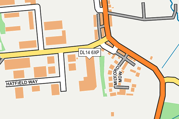
DL14 6XP is located in the Shildon and Dene Valley electoral ward, within the unitary authority of County Durham and the English Parliamentary constituency of Bishop Auckland. The Sub Integrated Care Board (ICB) Location is NHS North East and North Cumbria ICB - 84H and the police force is Durham. This postcode has been in use since July 1990.


GetTheData
Source: OS OpenMap – Local (Ordnance Survey)
Source: OS VectorMap District (Ordnance Survey)
Licence: Open Government Licence (requires attribution)
| Easting | 421885 |
| Northing | 527919 |
| Latitude | 54.645910 |
| Longitude | -1.662385 |
GetTheData
Source: Open Postcode Geo
Licence: Open Government Licence
| Country | England |
| Postcode District | DL14 |
| ➜ DL14 open data dashboard ➜ See where DL14 is on a map ➜ Where is Bishop Auckland? | |
GetTheData
Source: Land Registry Price Paid Data
Licence: Open Government Licence
Elevation or altitude of DL14 6XP as distance above sea level:
| Metres | Feet | |
|---|---|---|
| Elevation | 100m | 328ft |
Elevation is measured from the approximate centre of the postcode, to the nearest point on an OS contour line from OS Terrain 50, which has contour spacing of ten vertical metres.
➜ How high above sea level am I? Find the elevation of your current position using your device's GPS.
GetTheData
Source: Open Postcode Elevation
Licence: Open Government Licence
| Ward | Shildon And Dene Valley |
| Constituency | Bishop Auckland |
GetTheData
Source: ONS Postcode Database
Licence: Open Government Licence
| June 2022 | Violence and sexual offences | On or near Rosemount Road | 182m |
| June 2022 | Anti-social behaviour | On or near Adelaide Bank | 258m |
| June 2022 | Burglary | On or near Longfield Road | 377m |
| ➜ Get more crime data in our Crime section | |||
GetTheData
Source: data.police.uk
Licence: Open Government Licence
| Rosemount Road | South Church | 144m |
| Rosemount Road | South Church | 159m |
| Rosemount Garage (Rosemount Road) | South Church | 178m |
| Rosemount Garage (Rosemount Road) | South Church | 228m |
| Red Alligator (B6282 Auckland Road) | South Church | 440m |
| Bishop Auckland Station | 1.6km |
| Shildon Station | 2.8km |
| Newton Aycliffe Station | 5.9km |
GetTheData
Source: NaPTAN
Licence: Open Government Licence
GetTheData
Source: ONS Postcode Database
Licence: Open Government Licence


➜ Get more ratings from the Food Standards Agency
GetTheData
Source: Food Standards Agency
Licence: FSA terms & conditions
| Last Collection | |||
|---|---|---|---|
| Location | Mon-Fri | Sat | Distance |
| Rosemount | 17:30 | 11:15 | 97m |
| South Church | 17:30 | 11:15 | 427m |
| South Church Ind Estate | 18:30 | 438m | |
GetTheData
Source: Dracos
Licence: Creative Commons Attribution-ShareAlike
| Facility | Distance |
|---|---|
| Henknowle Recreation Ground Hampshire Place, Bishop Auckland Grass Pitches | 805m |
| Coundon Grange Recreation Ground Randolph Street, Coundon Grange Grass Pitches | 1.1km |
| Auckland Park Methodist Church Douglas Crescent, Auckland Park Sports Hall | 1.1km |
GetTheData
Source: Active Places
Licence: Open Government Licence
| School | Phase of Education | Distance |
|---|---|---|
| St Andrew's Primary School St Andrew's Road, Bishop Auckland, DL14 6RY | Primary | 612m |
| Prince Bishops Community Primary School Gibson Street, Coundon Grange, Bishop Auckland, DL14 8DY | Primary | 878m |
| Cockton Hill Junior School McIntyre Terrace, Cockton Hill, Bishop Auckland, DL14 6HW | Primary | 1.1km |
GetTheData
Source: Edubase
Licence: Open Government Licence
The below table lists the International Territorial Level (ITL) codes (formerly Nomenclature of Territorial Units for Statistics (NUTS) codes) and Local Administrative Units (LAU) codes for DL14 6XP:
| ITL 1 Code | Name |
|---|---|
| TLC | North East (England) |
| ITL 2 Code | Name |
| TLC1 | Tees Valley and Durham |
| ITL 3 Code | Name |
| TLC14 | Durham |
| LAU 1 Code | Name |
| E06000047 | County Durham |
GetTheData
Source: ONS Postcode Directory
Licence: Open Government Licence
The below table lists the Census Output Area (OA), Lower Layer Super Output Area (LSOA), and Middle Layer Super Output Area (MSOA) for DL14 6XP:
| Code | Name | |
|---|---|---|
| OA | E00105988 | |
| LSOA | E01020881 | County Durham 055E |
| MSOA | E02004352 | County Durham 055 |
GetTheData
Source: ONS Postcode Directory
Licence: Open Government Licence
| DL14 6TB | Northcliffe | 56m |
| DL14 6XF | Hatfield Way | 62m |
| DL14 6TD | Southcliffe | 67m |
| DL14 6SY | Rosemount Road | 85m |
| DL14 6TA | Bigland Terrace | 86m |
| DL14 6SJ | Milford Meadow | 117m |
| DL14 6SZ | West View | 133m |
| DL14 6SX | Rosemount Road | 178m |
| DL14 6XN | Rosemount Court | 210m |
| DL14 6TF | St Wilfrids Walk | 357m |
GetTheData
Source: Open Postcode Geo; Land Registry Price Paid Data
Licence: Open Government Licence