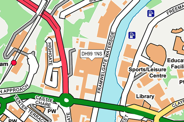
DH99 1NS is located in the Elvet and Gilesgate electoral ward, within the unitary authority of County Durham and the English Parliamentary constituency of City of Durham. The Sub Integrated Care Board (ICB) Location is NHS North East and North Cumbria ICB - 84H and the police force is Durham. This postcode has been in use since January 1980.


GetTheData
Source: OS OpenMap – Local (Ordnance Survey)
Source: OS VectorMap District (Ordnance Survey)
Licence: Open Government Licence (requires attribution)
| Easting | 427238 |
| Northing | 542787 |
| Latitude | 54.779259 |
| Longitude | -1.578053 |
GetTheData
Source: Open Postcode Geo
Licence: Open Government Licence
| Country | England |
| Postcode District | DH99 |
| ➜ DH99 open data dashboard ➜ Where is Durham? | |
GetTheData
Source: Land Registry Price Paid Data
Licence: Open Government Licence
Elevation or altitude of DH99 1NS as distance above sea level:
| Metres | Feet | |
|---|---|---|
| Elevation | 30m | 98ft |
Elevation is measured from the approximate centre of the postcode, to the nearest point on an OS contour line from OS Terrain 50, which has contour spacing of ten vertical metres.
➜ How high above sea level am I? Find the elevation of your current position using your device's GPS.
GetTheData
Source: Open Postcode Elevation
Licence: Open Government Licence
| Ward | Elvet And Gilesgate |
| Constituency | City Of Durham |
GetTheData
Source: ONS Postcode Database
Licence: Open Government Licence
| January 2024 | Anti-social behaviour | On or near Parking Area | 193m |
| January 2024 | Criminal damage and arson | On or near Parking Area | 193m |
| January 2024 | Public order | On or near Parking Area | 193m |
| ➜ Get more crime data in our Crime section | |||
GetTheData
Source: data.police.uk
Licence: Open Government Licence
| Freemans Place Bowling Alley (Street Not Known) | Durham | 157m |
| Railway Station Bus Stop (Station Approach) | Durham | 187m |
| Leazes Road - Millburngate Br (Leazes Road) | Durham | 217m |
| Millburngate Stand C (Milburngate) | Durham | 222m |
| Millburngate Stand B (Milburngate) | Durham | 236m |
| Durham Station | 0.2km |
GetTheData
Source: NaPTAN
Licence: Open Government Licence
GetTheData
Source: ONS Postcode Database
Licence: Open Government Licence


➜ Get more ratings from the Food Standards Agency
GetTheData
Source: Food Standards Agency
Licence: FSA terms & conditions
| Last Collection | |||
|---|---|---|---|
| Location | Mon-Fri | Sat | Distance |
| Durham Station | 17:00 | 12:00 | 233m |
| Market Place | 18:30 | 12:00 | 298m |
| North Road | 17:30 | 12:00 | 302m |
GetTheData
Source: Dracos
Licence: Creative Commons Attribution-ShareAlike
| Facility | Distance |
|---|---|
| Meridian Health & Fitness (Closed) Walkergate, Durham Studio, Swimming Pool, Health and Fitness Gym | 114m |
| Pace Health Club (Durham) Frankland Lane, Durham Health and Fitness Gym, Swimming Pool | 150m |
| Freemans Quay Leisure Centre Freemans Place, Durham Swimming Pool, Health and Fitness Gym, Sports Hall, Studio | 204m |
GetTheData
Source: Active Places
Licence: Open Government Licence
| School | Phase of Education | Distance |
|---|---|---|
| Durham Sixth Form Centre Providence Row, The Sands, Durham, DH1 1SG | 16 plus | 333m |
| The Independent Grammar School:Durham Claypath, Durham, DH1 1RH | Not applicable | 341m |
| University of Durham University Office, Old Evet, Durham, DH1 3HP | Not applicable | 720m |
GetTheData
Source: Edubase
Licence: Open Government Licence
| Risk of DH99 1NS flooding from rivers and sea | Medium |
| ➜ DH99 1NS flood map | |
GetTheData
Source: Open Flood Risk by Postcode
Licence: Open Government Licence
The below table lists the International Territorial Level (ITL) codes (formerly Nomenclature of Territorial Units for Statistics (NUTS) codes) and Local Administrative Units (LAU) codes for DH99 1NS:
| ITL 1 Code | Name |
|---|---|
| TLC | North East (England) |
| ITL 2 Code | Name |
| TLC1 | Tees Valley and Durham |
| ITL 3 Code | Name |
| TLC14 | Durham |
| LAU 1 Code | Name |
| E06000047 | County Durham |
GetTheData
Source: ONS Postcode Directory
Licence: Open Government Licence
The below table lists the Census Output Area (OA), Lower Layer Super Output Area (LSOA), and Middle Layer Super Output Area (MSOA) for DH99 1NS:
| Code | Name | |
|---|---|---|
| OA | E00105060 | |
| LSOA | E01020702 | County Durham 033B |
| MSOA | E02004315 | County Durham 033 |
GetTheData
Source: ONS Postcode Directory
Licence: Open Government Licence
| DH1 4GA | Highgate | 131m |
| DH1 5SY | Sidegate | 182m |
| DH1 5SX | Diamond Terrace | 201m |
| DH1 1SW | Freemans Quay | 204m |
| DH1 4TY | Castle Chare | 211m |
| DH1 4TZ | St Annes Court | 216m |
| DH1 3RP | Back Silver Street | 221m |
| DH1 4RD | Tenter Terrace | 251m |
| DH1 4SQ | North Road | 296m |
| DH1 4SW | Lambton Walk | 298m |
GetTheData
Source: Open Postcode Geo; Land Registry Price Paid Data
Licence: Open Government Licence