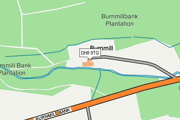
DH8 9TG is located in the South Tynedale electoral ward, within the unitary authority of Northumberland and the English Parliamentary constituency of Hexham. The Sub Integrated Care Board (ICB) Location is NHS North East and North Cumbria ICB - 00L and the police force is Northumbria. This postcode has been in use since January 1980.


GetTheData
Source: OS OpenMap – Local (Ordnance Survey)
Source: OS VectorMap District (Ordnance Survey)
Licence: Open Government Licence (requires attribution)
| Easting | 407376 |
| Northing | 552956 |
| Latitude | 54.871322 |
| Longitude | -1.886591 |
GetTheData
Source: Open Postcode Geo
Licence: Open Government Licence
| Country | England |
| Postcode District | DH8 |
| ➜ DH8 open data dashboard ➜ See where DH8 is on a map | |
GetTheData
Source: Land Registry Price Paid Data
Licence: Open Government Licence
Elevation or altitude of DH8 9TG as distance above sea level:
| Metres | Feet | |
|---|---|---|
| Elevation | 140m | 459ft |
Elevation is measured from the approximate centre of the postcode, to the nearest point on an OS contour line from OS Terrain 50, which has contour spacing of ten vertical metres.
➜ How high above sea level am I? Find the elevation of your current position using your device's GPS.
GetTheData
Source: Open Postcode Elevation
Licence: Open Government Licence
| Ward | South Tynedale |
| Constituency | Hexham |
GetTheData
Source: ONS Postcode Database
Licence: Open Government Licence
| Church (B6278) | Snods Edge | 974m |
| Church (B6278) | Snods Edge | 978m |
GetTheData
Source: NaPTAN
Licence: Open Government Licence
| Percentage of properties with Next Generation Access | 100.0% |
| Percentage of properties with Superfast Broadband | 0.0% |
| Percentage of properties with Ultrafast Broadband | 0.0% |
| Percentage of properties with Full Fibre Broadband | 0.0% |
Superfast Broadband is between 30Mbps and 300Mbps
Ultrafast Broadband is > 300Mbps
| Percentage of properties unable to receive 2Mbps | 0.0% |
| Percentage of properties unable to receive 5Mbps | 0.0% |
| Percentage of properties unable to receive 10Mbps | 0.0% |
| Percentage of properties unable to receive 30Mbps | 100.0% |
GetTheData
Source: Ofcom
Licence: Ofcom Terms of Use (requires attribution)
GetTheData
Source: ONS Postcode Database
Licence: Open Government Licence


➜ Get more ratings from the Food Standards Agency
GetTheData
Source: Food Standards Agency
Licence: FSA terms & conditions
| Last Collection | |||
|---|---|---|---|
| Location | Mon-Fri | Sat | Distance |
| Shotley Bridge Post Office | 16:00 | 12:00 | 1,782m |
| St Cuthberts, Benfieldside Road | 16:15 | 12:00 | 2,029m |
| Barley Mill Road, Bridgehill | 16:00 | 11:45 | 2,299m |
GetTheData
Source: Dracos
Licence: Creative Commons Attribution-ShareAlike
| Facility | Distance |
|---|---|
| Snods Edge Sports Field B6278 Carterway Heads To Burnmill Bank, Shotley Bridge Grass Pitches | 874m |
| Shotley Bridge Cricket Club The Spa Gardens, Consett Grass Pitches | 1.8km |
| Derwent Manor Hotel Allensford, Consett Health and Fitness Gym, Swimming Pool | 2.2km |
GetTheData
Source: Active Places
Licence: Open Government Licence
| School | Phase of Education | Distance |
|---|---|---|
| Shotley Bridge Primary School Benfieldside Road, Shotley Bridge, Consett, DH8 0SQ | Primary | 2.3km |
| Benfieldside Primary School Moorlands, Blackhill, Consett, DH8 0JX | Primary | 2.3km |
| St Mary's Catholic Primary School, Blackhill Pemberton Road, Blackhill, Consett, DH8 8JD | Primary | 2.4km |
GetTheData
Source: Edubase
Licence: Open Government Licence
| Risk of DH8 9TG flooding from rivers and sea | Medium |
| ➜ DH8 9TG flood map | |
GetTheData
Source: Open Flood Risk by Postcode
Licence: Open Government Licence
The below table lists the International Territorial Level (ITL) codes (formerly Nomenclature of Territorial Units for Statistics (NUTS) codes) and Local Administrative Units (LAU) codes for DH8 9TG:
| ITL 1 Code | Name |
|---|---|
| TLC | North East (England) |
| ITL 2 Code | Name |
| TLC2 | Northumberland, and Tyne and Wear |
| ITL 3 Code | Name |
| TLC21 | Northumberland |
| LAU 1 Code | Name |
| E06000057 | Northumberland |
GetTheData
Source: ONS Postcode Directory
Licence: Open Government Licence
The below table lists the Census Output Area (OA), Lower Layer Super Output Area (LSOA), and Middle Layer Super Output Area (MSOA) for DH8 9TG:
| Code | Name | |
|---|---|---|
| OA | E00139994 | |
| LSOA | E01027506 | Northumberland 039D |
| MSOA | E02005732 | Northumberland 039 |
GetTheData
Source: ONS Postcode Directory
Licence: Open Government Licence
| DH8 9TQ | 772m | |
| DH8 9LJ | 928m | |
| DH8 9JZ | 1284m | |
| DH8 9LE | 1290m | |
| DH8 9JY | 1316m | |
| DH8 9LF | 1344m | |
| DH8 9TE | 1514m | |
| DH8 8SF | Shotley Grove Road | 1584m |
| DH8 8SG | Shotley Grove Road | 1616m |
| DH8 8SE | 1635m |
GetTheData
Source: Open Postcode Geo; Land Registry Price Paid Data
Licence: Open Government Licence