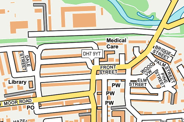
DH7 9YT is located in the Esh and Witton Gilbert electoral ward, within the unitary authority of County Durham and the English Parliamentary constituency of North West Durham. The Sub Integrated Care Board (ICB) Location is NHS North East and North Cumbria ICB - 84H and the police force is Durham. This postcode has been in use since January 1980.


GetTheData
Source: OS OpenMap – Local (Ordnance Survey)
Source: OS VectorMap District (Ordnance Survey)
Licence: Open Government Licence (requires attribution)
| Easting | 421329 |
| Northing | 545103 |
| Latitude | 54.800365 |
| Longitude | -1.669760 |
GetTheData
Source: Open Postcode Geo
Licence: Open Government Licence
| Country | England |
| Postcode District | DH7 |
| ➜ DH7 open data dashboard ➜ See where DH7 is on a map ➜ Where is Langley Park? | |
GetTheData
Source: Land Registry Price Paid Data
Licence: Open Government Licence
Elevation or altitude of DH7 9YT as distance above sea level:
| Metres | Feet | |
|---|---|---|
| Elevation | 100m | 328ft |
Elevation is measured from the approximate centre of the postcode, to the nearest point on an OS contour line from OS Terrain 50, which has contour spacing of ten vertical metres.
➜ How high above sea level am I? Find the elevation of your current position using your device's GPS.
GetTheData
Source: Open Postcode Elevation
Licence: Open Government Licence
| Ward | Esh And Witton Gilbert |
| Constituency | North West Durham |
GetTheData
Source: ONS Postcode Database
Licence: Open Government Licence
| June 2022 | Violence and sexual offences | On or near Browney Court | 38m |
| June 2022 | Shoplifting | On or near Browney Court | 38m |
| June 2022 | Criminal damage and arson | On or near Browney Court | 38m |
| ➜ Get more crime data in our Crime section | |||
GetTheData
Source: data.police.uk
Licence: Open Government Licence
| War Memorial (Front Street) | Langley Park | 75m |
| Youth Centre (Front Street) | Langley Park | 89m |
| Youth Centre (Front Street) | Langley Park | 141m |
| Quebec Street End (Low Moor Road) | Langley Park | 165m |
| The Rams Head (Low Moor Road) | Langley Park | 225m |
GetTheData
Source: NaPTAN
Licence: Open Government Licence
GetTheData
Source: ONS Postcode Database
Licence: Open Government Licence


➜ Get more ratings from the Food Standards Agency
GetTheData
Source: Food Standards Agency
Licence: FSA terms & conditions
| Last Collection | |||
|---|---|---|---|
| Location | Mon-Fri | Sat | Distance |
| Kingsway, Langley Park | 16:00 | 09:00 | 187m |
| Post Office, Church Street | 17:00 | 12:00 | 272m |
| The Crescent | 16:15 | 09:15 | 846m |
GetTheData
Source: Dracos
Licence: Creative Commons Attribution-ShareAlike
| Facility | Distance |
|---|---|
| Langley Park Primary School May Terrace, Langley Park, Durham Grass Pitches | 433m |
| Langley Park Sports & Social Club Low Moor Road, Langley Park, Durham Grass Pitches | 463m |
| The Recreation Ground (Closed) Bridge Street, Langley Park, Durham Grass Pitches | 559m |
GetTheData
Source: Active Places
Licence: Open Government Licence
| School | Phase of Education | Distance |
|---|---|---|
| Langley Park Primary School Langley Park, Durham, DH7 9XN | Primary | 433m |
| Esh CofE (Aided) Primary School Front Street, Esh, Durham, DH7 9QR | Primary | 1.9km |
| St Michael's Catholic Primary School, Esh Village Esh Village, Durham, DH7 9QY | Primary | 2km |
GetTheData
Source: Edubase
Licence: Open Government Licence
The below table lists the International Territorial Level (ITL) codes (formerly Nomenclature of Territorial Units for Statistics (NUTS) codes) and Local Administrative Units (LAU) codes for DH7 9YT:
| ITL 1 Code | Name |
|---|---|
| TLC | North East (England) |
| ITL 2 Code | Name |
| TLC1 | Tees Valley and Durham |
| ITL 3 Code | Name |
| TLC14 | Durham |
| LAU 1 Code | Name |
| E06000047 | County Durham |
GetTheData
Source: ONS Postcode Directory
Licence: Open Government Licence
The below table lists the Census Output Area (OA), Lower Layer Super Output Area (LSOA), and Middle Layer Super Output Area (MSOA) for DH7 9YT:
| Code | Name | |
|---|---|---|
| OA | E00104824 | |
| LSOA | E01020658 | County Durham 024B |
| MSOA | E02004307 | County Durham 024 |
GetTheData
Source: ONS Postcode Directory
Licence: Open Government Licence
| DH7 9SD | Front Street | 39m |
| DH7 9SA | Front Street | 85m |
| DH7 9SG | Front Street | 92m |
| DH7 9ST | Oak Street | 113m |
| DH7 9SS | Wood View | 128m |
| DH7 9SB | Thomas Street | 134m |
| DH7 9YS | Railway Street | 141m |
| DH7 9XB | Front Street | 148m |
| DH7 9YN | Logan Street | 149m |
| DH7 9YL | George Street | 149m |
GetTheData
Source: Open Postcode Geo; Land Registry Price Paid Data
Licence: Open Government Licence