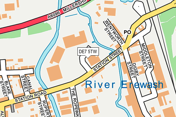
DE7 5TW is located in the Larklands electoral ward, within the local authority district of Erewash and the English Parliamentary constituency of Erewash. The Sub Integrated Care Board (ICB) Location is NHS Derby and Derbyshire ICB - 15M and the police force is Derbyshire. This postcode has been in use since January 1980.


GetTheData
Source: OS OpenMap – Local (Ordnance Survey)
Source: OS VectorMap District (Ordnance Survey)
Licence: Open Government Licence (requires attribution)
| Easting | 447233 |
| Northing | 342441 |
| Latitude | 52.977244 |
| Longitude | -1.298023 |
GetTheData
Source: Open Postcode Geo
Licence: Open Government Licence
| Country | England |
| Postcode District | DE7 |
| ➜ DE7 open data dashboard ➜ See where DE7 is on a map ➜ Where is Ilkeston? | |
GetTheData
Source: Land Registry Price Paid Data
Licence: Open Government Licence
Elevation or altitude of DE7 5TW as distance above sea level:
| Metres | Feet | |
|---|---|---|
| Elevation | 50m | 164ft |
Elevation is measured from the approximate centre of the postcode, to the nearest point on an OS contour line from OS Terrain 50, which has contour spacing of ten vertical metres.
➜ How high above sea level am I? Find the elevation of your current position using your device's GPS.
GetTheData
Source: Open Postcode Elevation
Licence: Open Government Licence
| Ward | Larklands |
| Constituency | Erewash |
GetTheData
Source: ONS Postcode Database
Licence: Open Government Licence
| June 2022 | Public order | On or near Parking Area | 59m |
| June 2022 | Shoplifting | On or near Parking Area | 59m |
| June 2022 | Shoplifting | On or near Parking Area | 59m |
| ➜ Get more crime data in our Crime section | |||
GetTheData
Source: data.police.uk
Licence: Open Government Licence
| Digby Street (Station Road) | Ilkeston | 56m |
| Digby Street (Station Road) | Ilkeston | 74m |
| Taylor Street (Station Road) | Ilkeston | 270m |
| Taylor Street (Station Road) | Ilkeston | 393m |
| Soloman Road (Coronation Road) | Cossall Marsh | 521m |
| Ilkeston Station | 0.3km |
| Langley Mill Station | 5.1km |
GetTheData
Source: NaPTAN
Licence: Open Government Licence
GetTheData
Source: ONS Postcode Database
Licence: Open Government Licence


➜ Get more ratings from the Food Standards Agency
GetTheData
Source: Food Standards Agency
Licence: FSA terms & conditions
| Last Collection | |||
|---|---|---|---|
| Location | Mon-Fri | Sat | Distance |
| Ilkeston Junction | 17:30 | 07:15 | 179m |
| Alvenor Street | 17:30 | 07:15 | 344m |
| Barker Gate | 17:30 | 07:30 | 572m |
GetTheData
Source: Dracos
Licence: Creative Commons Attribution-ShareAlike
| Facility | Distance |
|---|---|
| Gordon Street Recreation Ground Gordon Street, Ilkeston Grass Pitches | 296m |
| Anytime Fitness (Ilkeston) Rutland Street, Ilkeston Health and Fitness Gym, Studio | 465m |
| Ilkeston Gym (Closed) Wood Street, Ilkeston Health and Fitness Gym | 533m |
GetTheData
Source: Active Places
Licence: Open Government Licence
| School | Phase of Education | Distance |
|---|---|---|
| Chaucer Junior School Cranmer Street, Ilkeston, DE7 5JH | Primary | 594m |
| Chaucer Infant School Cantelupe Road, Ilkeston, DE7 5LN | Primary | 746m |
| Blue Mountain Education Willow Farm, Off Newton Lane, Ilkeston, Cossall, NG16 2SD | Not applicable | 752m |
GetTheData
Source: Edubase
Licence: Open Government Licence
| Risk of DE7 5TW flooding from rivers and sea | Low |
| ➜ DE7 5TW flood map | |
GetTheData
Source: Open Flood Risk by Postcode
Licence: Open Government Licence
The below table lists the International Territorial Level (ITL) codes (formerly Nomenclature of Territorial Units for Statistics (NUTS) codes) and Local Administrative Units (LAU) codes for DE7 5TW:
| ITL 1 Code | Name |
|---|---|
| TLF | East Midlands (England) |
| ITL 2 Code | Name |
| TLF1 | Derbyshire and Nottinghamshire |
| ITL 3 Code | Name |
| TLF13 | South and West Derbyshire |
| LAU 1 Code | Name |
| E07000036 | Erewash |
GetTheData
Source: ONS Postcode Directory
Licence: Open Government Licence
The below table lists the Census Output Area (OA), Lower Layer Super Output Area (LSOA), and Middle Layer Super Output Area (MSOA) for DE7 5TW:
| Code | Name | |
|---|---|---|
| OA | E00099481 | |
| LSOA | E01019661 | Erewash 003C |
| MSOA | E02004080 | Erewash 003 |
GetTheData
Source: ONS Postcode Directory
Licence: Open Government Licence
| DE7 5TD | Albert Villas | 55m |
| DE7 5TF | Wentworth Street | 139m |
| DE7 5TE | Station Street | 164m |
| DE7 5TG | Digby Street | 184m |
| DE7 5HX | Rope Walk | 212m |
| DE7 8GR | Canal Street | 218m |
| DE7 5LP | Rupert Street | 221m |
| DE7 5LJ | Station Road | 233m |
| DE7 8GQ | Mill Street | 240m |
| DE7 5LZ | Allison Gardens | 259m |
GetTheData
Source: Open Postcode Geo; Land Registry Price Paid Data
Licence: Open Government Licence