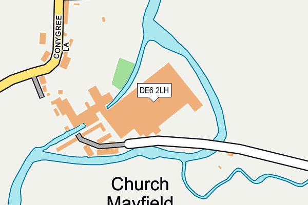
DE6 2LH is located in the Stramshall & Weaver electoral ward, within the local authority district of East Staffordshire and the English Parliamentary constituency of Burton. The Sub Integrated Care Board (ICB) Location is NHS Staffordshire and Stoke-on-Trent ICB - 05D and the police force is Staffordshire. This postcode has been in use since January 1980.


GetTheData
Source: OS OpenMap – Local (Ordnance Survey)
Source: OS VectorMap District (Ordnance Survey)
Licence: Open Government Licence (requires attribution)
| Easting | 415913 |
| Northing | 344816 |
| Latitude | 53.000432 |
| Longitude | -1.764336 |
GetTheData
Source: Open Postcode Geo
Licence: Open Government Licence
| Country | England |
| Postcode District | DE6 |
| ➜ DE6 open data dashboard ➜ See where DE6 is on a map ➜ Where is Mayfield? | |
GetTheData
Source: Land Registry Price Paid Data
Licence: Open Government Licence
Elevation or altitude of DE6 2LH as distance above sea level:
| Metres | Feet | |
|---|---|---|
| Elevation | 110m | 361ft |
Elevation is measured from the approximate centre of the postcode, to the nearest point on an OS contour line from OS Terrain 50, which has contour spacing of ten vertical metres.
➜ How high above sea level am I? Find the elevation of your current position using your device's GPS.
GetTheData
Source: Open Postcode Elevation
Licence: Open Government Licence
| Ward | Stramshall & Weaver |
| Constituency | Burton |
GetTheData
Source: ONS Postcode Database
Licence: Open Government Licence
| May 2022 | Drugs | On or near Sports/Recreation Area | 190m |
| April 2022 | Violence and sexual offences | On or near Conygree Lane | 443m |
| July 2021 | Violence and sexual offences | On or near Sports/Recreation Area | 190m |
| ➜ Get more crime data in our Crime section | |||
GetTheData
Source: data.police.uk
Licence: Open Government Licence
| The Crescent (Mayfield Avenue) | Mayfield | 417m |
| Sycamore Road (Mayfield Avenue) | Mayfield | 524m |
| Mayfield Avenue (Conygree Lane) | Mayfield | 577m |
| Henry Prince School (Ashbourne Road) | Mayfield | 714m |
| Cock Hill | Clifton | 722m |
GetTheData
Source: NaPTAN
Licence: Open Government Licence
GetTheData
Source: ONS Postcode Database
Licence: Open Government Licence


➜ Get more ratings from the Food Standards Agency
GetTheData
Source: Food Standards Agency
Licence: FSA terms & conditions
| Last Collection | |||
|---|---|---|---|
| Location | Mon-Fri | Sat | Distance |
| Mayfield | 17:00 | 09:30 | 206m |
| Old Clifton Post Office | 17:30 | 11:00 | 745m |
| Mayfield So | 17:15 | 11:15 | 756m |
GetTheData
Source: Dracos
Licence: Creative Commons Attribution-ShareAlike
| Facility | Distance |
|---|---|
| Mayfield Playing Field Weirside, Mayfield, Ashbourne Grass Pitches | 326m |
| Clifton Cricket Club Chapel Lane, Clifton Grass Pitches | 746m |
| Ashbourne Golf Club Wyaston Road, Ashbourne Golf | 1.7km |
GetTheData
Source: Active Places
Licence: Open Government Licence
| School | Phase of Education | Distance |
|---|---|---|
| Clifton CofE Primary School Cross Side, Clifton Village, Ashbourne, DE6 2GJ | Primary | 834m |
| St Oswald's CofE Primary School Mayfield Road, Ashbourne, DE6 1AS | Primary | 2.4km |
| Ashbourne Hilltop Primary and Nursery School Wyaston Road, Ashbourne, DE6 1NB | Primary | 2.6km |
GetTheData
Source: Edubase
Licence: Open Government Licence
| Risk of DE6 2LH flooding from rivers and sea | High |
| ➜ DE6 2LH flood map | |
GetTheData
Source: Open Flood Risk by Postcode
Licence: Open Government Licence
The below table lists the International Territorial Level (ITL) codes (formerly Nomenclature of Territorial Units for Statistics (NUTS) codes) and Local Administrative Units (LAU) codes for DE6 2LH:
| ITL 1 Code | Name |
|---|---|
| TLG | West Midlands (England) |
| ITL 2 Code | Name |
| TLG2 | Shropshire and Staffordshire |
| ITL 3 Code | Name |
| TLG24 | Staffordshire CC |
| LAU 1 Code | Name |
| E07000193 | East Staffordshire |
GetTheData
Source: ONS Postcode Directory
Licence: Open Government Licence
The below table lists the Census Output Area (OA), Lower Layer Super Output Area (LSOA), and Middle Layer Super Output Area (MSOA) for DE6 2LH:
| Code | Name | |
|---|---|---|
| OA | E00150134 | |
| LSOA | E01029467 | East Staffordshire 001E |
| MSOA | E02006131 | East Staffordshire 001 |
GetTheData
Source: ONS Postcode Directory
Licence: Open Government Licence
| DE6 2JP | South View | 134m |
| DE6 2JL | Mayfield Terrace | 155m |
| DE6 2JN | West View | 162m |
| DE6 2JJ | Church View | 194m |
| DE6 2JH | Meadowside | 247m |
| DE6 2JG | Weirside | 271m |
| DE6 2JR | Church Lane | 368m |
| DE6 2HW | Conygree Lane | 382m |
| DE6 2JB | Mayfield Avenue | 489m |
| DE6 2JF | East View | 492m |
GetTheData
Source: Open Postcode Geo; Land Registry Price Paid Data
Licence: Open Government Licence