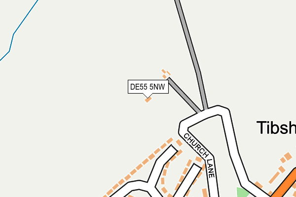
DE55 5NW is in Tibshelf, Alfreton. DE55 5NW is located in the Tibshelf electoral ward, within the local authority district of Bolsover and the English Parliamentary constituency of Bolsover. The Sub Integrated Care Board (ICB) Location is NHS Derby and Derbyshire ICB - 15M and the police force is Derbyshire. This postcode has been in use since August 1992.


GetTheData
Source: OS OpenMap – Local (Ordnance Survey)
Source: OS VectorMap District (Ordnance Survey)
Licence: Open Government Licence (requires attribution)
| Easting | 443815 |
| Northing | 361144 |
| Latitude | 53.145665 |
| Longitude | -1.346382 |
GetTheData
Source: Open Postcode Geo
Licence: Open Government Licence
| Locality | Tibshelf |
| Town/City | Alfreton |
| Country | England |
| Postcode District | DE55 |
| ➜ DE55 open data dashboard ➜ See where DE55 is on a map | |
GetTheData
Source: Land Registry Price Paid Data
Licence: Open Government Licence
Elevation or altitude of DE55 5NW as distance above sea level:
| Metres | Feet | |
|---|---|---|
| Elevation | 150m | 492ft |
Elevation is measured from the approximate centre of the postcode, to the nearest point on an OS contour line from OS Terrain 50, which has contour spacing of ten vertical metres.
➜ How high above sea level am I? Find the elevation of your current position using your device's GPS.
GetTheData
Source: Open Postcode Elevation
Licence: Open Government Licence
| Ward | Tibshelf |
| Constituency | Bolsover |
GetTheData
Source: ONS Postcode Database
Licence: Open Government Licence
| May 2023 | Other theft | On or near Petrol Station | 320m |
| May 2023 | Violence and sexual offences | On or near Petrol Station | 320m |
| June 2022 | Violence and sexual offences | On or near Derwent Drive | 300m |
| ➜ Get more crime data in our Crime section | |||
GetTheData
Source: data.police.uk
Licence: Open Government Licence
| Church Lane (High Street) | Tibshelf | 360m |
| Brooke Street (High Street) | Tibshelf | 417m |
| Wheatsheaf (High Street) | Tibshelf | 440m |
| Wheatsheaf (High Street) | Tibshelf | 456m |
| Brooke Street (High Street) | Tibshelf | 462m |
GetTheData
Source: NaPTAN
Licence: Open Government Licence
GetTheData
Source: ONS Postcode Database
Licence: Open Government Licence


➜ Get more ratings from the Food Standards Agency
GetTheData
Source: Food Standards Agency
Licence: FSA terms & conditions
| Last Collection | |||
|---|---|---|---|
| Location | Mon-Fri | Sat | Distance |
| West View | 16:30 | 08:00 | 405m |
| Tibshelf Post Office | 16:30 | 08:00 | 425m |
| Classic Journeys Box | 16:30 | 08:00 | 508m |
GetTheData
Source: Dracos
Licence: Creative Commons Attribution-ShareAlike
| Facility | Distance |
|---|---|
| Tibshelf Community Sports Field High Street, Tibshelf, Alfreton Artificial Grass Pitch, Grass Pitches, Outdoor Tennis Courts | 273m |
| Exercise 4 All (Closed) High Street, Tibshelf, Alfreton Health and Fitness Gym | 448m |
| Tibshelf Community School & Specialist Sports College (Closed) High Street, Tibshelf, Alfreton Grass Pitches, Sports Hall, Artificial Grass Pitch | 455m |
GetTheData
Source: Active Places
Licence: Open Government Licence
| School | Phase of Education | Distance |
|---|---|---|
| Tibshelf Infant School 144 High Street, Tibshelf, Alfreton, DE55 5PP | Primary | 424m |
| Tibshelf Community School Doe Hill Lane, Tibshelf, Alfreton, DE55 5LZ | Secondary | 797m |
| Town End Junior School Alfreton Road, Tibshelf, Alfreton, DE55 5PB | Primary | 1.2km |
GetTheData
Source: Edubase
Licence: Open Government Licence
The below table lists the International Territorial Level (ITL) codes (formerly Nomenclature of Territorial Units for Statistics (NUTS) codes) and Local Administrative Units (LAU) codes for DE55 5NW:
| ITL 1 Code | Name |
|---|---|
| TLF | East Midlands (England) |
| ITL 2 Code | Name |
| TLF1 | Derbyshire and Nottinghamshire |
| ITL 3 Code | Name |
| TLF12 | East Derbyshire |
| LAU 1 Code | Name |
| E07000033 | Bolsover |
GetTheData
Source: ONS Postcode Directory
Licence: Open Government Licence
The below table lists the Census Output Area (OA), Lower Layer Super Output Area (LSOA), and Middle Layer Super Output Area (MSOA) for DE55 5NW:
| Code | Name | |
|---|---|---|
| OA | E00098726 | |
| LSOA | E01019520 | Bolsover 008C |
| MSOA | E02004052 | Bolsover 008 |
GetTheData
Source: ONS Postcode Directory
Licence: Open Government Licence
| DE55 5LT | Derwent Drive | 190m |
| DE55 5LR | Peveril Road | 259m |
| DE55 5LA | Monsal Crescent | 328m |
| DE55 5LS | Derwent Drive | 359m |
| DE55 5LU | Lathkil Grove | 365m |
| DE55 5NU | High Street | 366m |
| DE55 5LQ | Peveril Road | 438m |
| DE55 5NT | Vicar Lane | 444m |
| DE55 5QG | Lincoln Close | 447m |
| DE55 5PP | High Street | 448m |
GetTheData
Source: Open Postcode Geo; Land Registry Price Paid Data
Licence: Open Government Licence