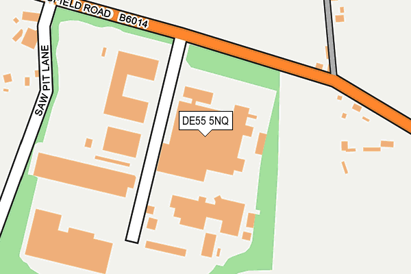
DE55 5NQ lies on Sawpit Lane in Tibshelf, Alfreton. DE55 5NQ is located in the Tibshelf electoral ward, within the local authority district of Bolsover and the English Parliamentary constituency of Bolsover. The Sub Integrated Care Board (ICB) Location is NHS Derby and Derbyshire ICB - 15M and the police force is Derbyshire. This postcode has been in use since August 1992.


GetTheData
Source: OS OpenMap – Local (Ordnance Survey)
Source: OS VectorMap District (Ordnance Survey)
Licence: Open Government Licence (requires attribution)
| Easting | 445270 |
| Northing | 361047 |
| Latitude | 53.144652 |
| Longitude | -1.324646 |
GetTheData
Source: Open Postcode Geo
Licence: Open Government Licence
| Street | Sawpit Lane |
| Locality | Tibshelf |
| Town/City | Alfreton |
| Country | England |
| Postcode District | DE55 |
| ➜ DE55 open data dashboard ➜ See where DE55 is on a map ➜ Where is Tibshelf? | |
GetTheData
Source: Land Registry Price Paid Data
Licence: Open Government Licence
Elevation or altitude of DE55 5NQ as distance above sea level:
| Metres | Feet | |
|---|---|---|
| Elevation | 190m | 623ft |
Elevation is measured from the approximate centre of the postcode, to the nearest point on an OS contour line from OS Terrain 50, which has contour spacing of ten vertical metres.
➜ How high above sea level am I? Find the elevation of your current position using your device's GPS.
GetTheData
Source: Open Postcode Elevation
Licence: Open Government Licence
| Ward | Tibshelf |
| Constituency | Bolsover |
GetTheData
Source: ONS Postcode Database
Licence: Open Government Licence
| May 2022 | Criminal damage and arson | On or near Mansfield Road | 344m |
| April 2022 | Anti-social behaviour | On or near Wharf Lane | 213m |
| April 2022 | Anti-social behaviour | On or near Mansfield Road | 344m |
| ➜ Get more crime data in our Crime section | |||
GetTheData
Source: data.police.uk
Licence: Open Government Licence
| Saw Pit Industrial Estate (Mansfield Road) | Tibshelf | 137m |
| Saw Pit Industrial Estate (Mansfield Road) | Tibshelf | 153m |
| Wharf Lane (Wild Hill) | Tibshelf Wharf | 285m |
| Wharf Lane (Wild Hill) | Tibshelf Wharf | 310m |
| Saw Pit Lane (Mansfield Road) | Tibshelf | 354m |
| Alfreton Station | 5.8km |
| Kirkby in Ashfield Station | 6.9km |
GetTheData
Source: NaPTAN
Licence: Open Government Licence
GetTheData
Source: ONS Postcode Database
Licence: Open Government Licence


➜ Get more ratings from the Food Standards Agency
GetTheData
Source: Food Standards Agency
Licence: FSA terms & conditions
| Last Collection | |||
|---|---|---|---|
| Location | Mon-Fri | Sat | Distance |
| White Hart | 16:00 | 08:00 | 606m |
| Wild Hill | 16:15 | 11:00 | 1,002m |
| Tibshelf Post Office | 16:30 | 08:00 | 1,047m |
GetTheData
Source: Dracos
Licence: Creative Commons Attribution-ShareAlike
| Facility | Distance |
|---|---|
| Tibshelf Community School & Specialist Sports College (Closed) High Street, Tibshelf, Alfreton Grass Pitches, Sports Hall, Artificial Grass Pitch | 1km |
| Exercise 4 All (Closed) High Street, Tibshelf, Alfreton Health and Fitness Gym | 1km |
| Tibshelf Community Sports Field High Street, Tibshelf, Alfreton Artificial Grass Pitch, Grass Pitches, Outdoor Tennis Courts | 1.2km |
GetTheData
Source: Active Places
Licence: Open Government Licence
| School | Phase of Education | Distance |
|---|---|---|
| Tibshelf Infant School 144 High Street, Tibshelf, Alfreton, DE55 5PP | Primary | 1km |
| Newton Primary School Hall Lane, Newton, Newton Primary School, Alfreton, DE55 5TL | Primary | 1.9km |
| Woodland View Primary School Barker Street, Huthwaite, Sutton-in-Ashfield, NG17 2LH | Primary | 1.9km |
GetTheData
Source: Edubase
Licence: Open Government Licence
The below table lists the International Territorial Level (ITL) codes (formerly Nomenclature of Territorial Units for Statistics (NUTS) codes) and Local Administrative Units (LAU) codes for DE55 5NQ:
| ITL 1 Code | Name |
|---|---|
| TLF | East Midlands (England) |
| ITL 2 Code | Name |
| TLF1 | Derbyshire and Nottinghamshire |
| ITL 3 Code | Name |
| TLF12 | East Derbyshire |
| LAU 1 Code | Name |
| E07000033 | Bolsover |
GetTheData
Source: ONS Postcode Directory
Licence: Open Government Licence
The below table lists the Census Output Area (OA), Lower Layer Super Output Area (LSOA), and Middle Layer Super Output Area (MSOA) for DE55 5NQ:
| Code | Name | |
|---|---|---|
| OA | E00098728 | |
| LSOA | E01019521 | Bolsover 008D |
| MSOA | E02004052 | Bolsover 008 |
GetTheData
Source: ONS Postcode Directory
Licence: Open Government Licence
| DE55 5NH | Sawpit Lane | 188m |
| DE55 5NG | Mansfield Road | 303m |
| DE55 5LF | Poppy Gardens | 591m |
| DE55 5LG | Overmoor View | 620m |
| NG17 3JF | Wild Hill | 627m |
| DE55 5NF | Mansfield Road | 631m |
| DE55 5LJ | Jasmine Drive | 637m |
| DE55 5JA | Clover Court | 659m |
| DE55 5NB | Meadow Close | 663m |
| DE55 5LH | Lavender Close | 723m |
GetTheData
Source: Open Postcode Geo; Land Registry Price Paid Data
Licence: Open Government Licence