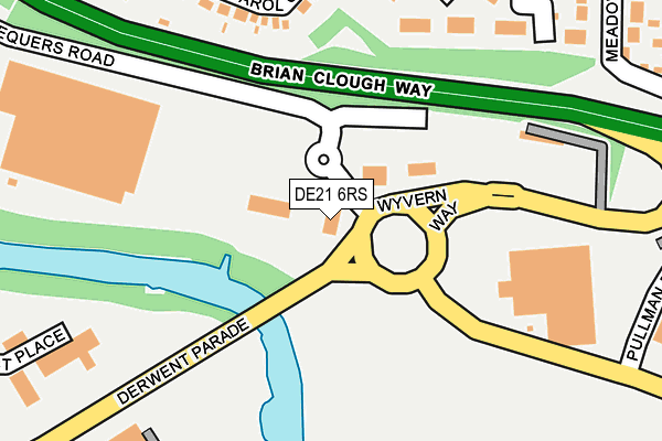
DE21 6RS is located in the Chaddesden East electoral ward, within the unitary authority of Derby and the English Parliamentary constituency of Derby North. The Sub Integrated Care Board (ICB) Location is NHS Derby and Derbyshire ICB - 15M and the police force is Derbyshire. This postcode has been in use since December 2000.


GetTheData
Source: OS OpenMap – Local (Ordnance Survey)
Source: OS VectorMap District (Ordnance Survey)
Licence: Open Government Licence (requires attribution)
| Easting | 437647 |
| Northing | 335844 |
| Latitude | 52.918721 |
| Longitude | -1.441536 |
GetTheData
Source: Open Postcode Geo
Licence: Open Government Licence
| Country | England |
| Postcode District | DE21 |
| ➜ DE21 open data dashboard ➜ See where DE21 is on a map ➜ Where is Derby? | |
GetTheData
Source: Land Registry Price Paid Data
Licence: Open Government Licence
Elevation or altitude of DE21 6RS as distance above sea level:
| Metres | Feet | |
|---|---|---|
| Elevation | 50m | 164ft |
Elevation is measured from the approximate centre of the postcode, to the nearest point on an OS contour line from OS Terrain 50, which has contour spacing of ten vertical metres.
➜ How high above sea level am I? Find the elevation of your current position using your device's GPS.
GetTheData
Source: Open Postcode Elevation
Licence: Open Government Licence
| Ward | Chaddesden East |
| Constituency | Derby North |
GetTheData
Source: ONS Postcode Database
Licence: Open Government Licence
| December 2023 | Public order | On or near Ashworth Avenue | 283m |
| November 2023 | Vehicle crime | On or near Ashworth Avenue | 283m |
| July 2023 | Vehicle crime | On or near Ashworth Avenue | 283m |
| ➜ Get more crime data in our Crime section | |||
GetTheData
Source: data.police.uk
Licence: Open Government Licence
| Wyvernside (Derwent Parade) | Wyvern Park | 71m |
| Wyvernside (Derwent Parade) | Wyvern Park | 151m |
| Millenium Way (Derwent Parade) | Pride Park | 347m |
| Football Stadium (Derwent Parade) | Pride Park | 554m |
| Wyvern Sainsburys (Wyvern Way) | Wyvern Park | 558m |
| Derby Station | 1.5km |
| Spondon Station | 2.2km |
| Peartree Station | 3.2km |
GetTheData
Source: NaPTAN
Licence: Open Government Licence
GetTheData
Source: ONS Postcode Database
Licence: Open Government Licence


➜ Get more ratings from the Food Standards Agency
GetTheData
Source: Food Standards Agency
Licence: FSA terms & conditions
| Last Collection | |||
|---|---|---|---|
| Location | Mon-Fri | Sat | Distance |
| Highfield Lane | 17:30 | 10:30 | 366m |
| Albert Road | 17:30 | 10:30 | 411m |
| Chaddesden Post Office | 17:30 | 12:00 | 603m |
GetTheData
Source: Dracos
Licence: Creative Commons Attribution-ShareAlike
| Facility | Distance |
|---|---|
| Everlast Gyms (Derby) Derwent Parade, Pride Park, Derby Swimming Pool, Health and Fitness Gym, Studio | 358m |
| Powerleague (Derby) (Closed) Derwent Parade, Pride Park, Derby Artificial Grass Pitch | 379m |
| Derby County Fc (Pride Park) Pride Park, Derby Grass Pitches | 627m |
GetTheData
Source: Active Places
Licence: Open Government Licence
| School | Phase of Education | Distance |
|---|---|---|
| Meadow Farm Community Primary School Foyle Avenue, Chaddesden, Derby, DE21 6TZ | Primary | 566m |
| St Alban's Catholic Voluntary Academy Newstead Avenue, Chaddesden, Derby, DE21 6NU | Primary | 949m |
| Derby Pride Academy 20 Orient Way, Pride Park, Derby, DE24 8BY | Not applicable | 1.1km |
GetTheData
Source: Edubase
Licence: Open Government Licence
| Risk of DE21 6RS flooding from rivers and sea | Medium |
| ➜ DE21 6RS flood map | |
GetTheData
Source: Open Flood Risk by Postcode
Licence: Open Government Licence
The below table lists the International Territorial Level (ITL) codes (formerly Nomenclature of Territorial Units for Statistics (NUTS) codes) and Local Administrative Units (LAU) codes for DE21 6RS:
| ITL 1 Code | Name |
|---|---|
| TLF | East Midlands (England) |
| ITL 2 Code | Name |
| TLF1 | Derbyshire and Nottinghamshire |
| ITL 3 Code | Name |
| TLF11 | Derby |
| LAU 1 Code | Name |
| E06000015 | Derby |
GetTheData
Source: ONS Postcode Directory
Licence: Open Government Licence
The below table lists the Census Output Area (OA), Lower Layer Super Output Area (LSOA), and Middle Layer Super Output Area (MSOA) for DE21 6RS:
| Code | Name | |
|---|---|---|
| OA | E00068220 | |
| LSOA | E01013509 | Derby 012C |
| MSOA | E02002807 | Derby 012 |
GetTheData
Source: ONS Postcode Directory
Licence: Open Government Licence
| DE21 6QH | John Berrysford Close | 194m |
| DE21 6PQ | Carol Crescent | 197m |
| DE21 6QG | Ashworth Walk | 220m |
| DE21 6PT | Meadow Lane | 236m |
| DE21 6RQ | Ashworth Avenue | 246m |
| DE21 6PP | Margaret Avenue | 257m |
| DE21 6PJ | Highfield Lane | 325m |
| DE21 6PN | Ashworth Avenue | 332m |
| DE21 6PU | Meadow Lane | 350m |
| DE21 6SR | Olive Grove | 359m |
GetTheData
Source: Open Postcode Geo; Land Registry Price Paid Data
Licence: Open Government Licence