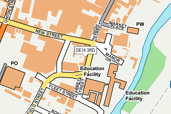
DE14 3RD lies on Lichfield Street in Burton-on-trent. DE14 3RD is located in the Burton & Eton electoral ward, within the local authority district of East Staffordshire and the English Parliamentary constituency of Burton. The Sub Integrated Care Board (ICB) Location is NHS Staffordshire and Stoke-on-Trent ICB - 05D and the police force is Staffordshire. This postcode has been in use since January 1980.


GetTheData
Source: OS OpenMap – Local (Ordnance Survey)
Source: OS VectorMap District (Ordnance Survey)
Licence: Open Government Licence (requires attribution)
| Easting | 424934 |
| Northing | 322621 |
| Latitude | 52.800576 |
| Longitude | -1.631616 |
GetTheData
Source: Open Postcode Geo
Licence: Open Government Licence
| Street | Lichfield Street |
| Town/City | Burton-on-trent |
| Country | England |
| Postcode District | DE14 |
| ➜ DE14 open data dashboard ➜ See where DE14 is on a map ➜ Where is Burton upon Trent? | |
GetTheData
Source: Land Registry Price Paid Data
Licence: Open Government Licence
Elevation or altitude of DE14 3RD as distance above sea level:
| Metres | Feet | |
|---|---|---|
| Elevation | 50m | 164ft |
Elevation is measured from the approximate centre of the postcode, to the nearest point on an OS contour line from OS Terrain 50, which has contour spacing of ten vertical metres.
➜ How high above sea level am I? Find the elevation of your current position using your device's GPS.
GetTheData
Source: Open Postcode Elevation
Licence: Open Government Licence
| Ward | Burton & Eton |
| Constituency | Burton |
GetTheData
Source: ONS Postcode Database
Licence: Open Government Licence
6, LICHFIELD STREET, BURTON-ON-TRENT, DE14 3RD 2003 5 FEB £160,000 |
➜ Burton upon Trent house prices
GetTheData
Source: HM Land Registry Price Paid Data
Licence: Contains HM Land Registry data © Crown copyright and database right 2024. This data is licensed under the Open Government Licence v3.0.
| January 2024 | Violence and sexual offences | On or near Caxton Court | 447m |
| January 2024 | Violence and sexual offences | On or near Caxton Court | 447m |
| November 2023 | Shoplifting | On or near Caxton Court | 447m |
| ➜ Get more crime data in our Crime section | |||
GetTheData
Source: data.police.uk
Licence: Open Government Licence
| Lichfield Street (Lichfield St) | Burton Upon Trent | 36m |
| New Street (New St) | Burton Upon Trent | 64m |
| New Street (New St) | Burton Upon Trent | 67m |
| High Street (High St) | Burton Upon Trent | 81m |
| High Street | Burton Upon Trent | 90m |
| Burton-on-Trent Station | 0.9km |
GetTheData
Source: NaPTAN
Licence: Open Government Licence
GetTheData
Source: ONS Postcode Database
Licence: Open Government Licence


➜ Get more ratings from the Food Standards Agency
GetTheData
Source: Food Standards Agency
Licence: FSA terms & conditions
| Last Collection | |||
|---|---|---|---|
| Location | Mon-Fri | Sat | Distance |
| St Modwens Walk | 18:30 | 11:45 | 74m |
| Burton Safeways Post Office | 17:30 | 12:00 | 254m |
| Burton Safeways Post Office | 18:30 | 12:15 | 274m |
GetTheData
Source: Dracos
Licence: Creative Commons Attribution-ShareAlike
| Facility | Distance |
|---|---|
| Everlast Gyms (Burton Upon Trent) Middleway Park, Burton-on-trent Swimming Pool, Health and Fitness Gym, Studio | 448m |
| Meadowside Leisure Centre High Street, Burton-on-trent Sports Hall, Swimming Pool, Health and Fitness Gym, Studio, Squash Courts | 632m |
| The Gym Group (Burton Upon Trent) Middleway Park, Guild Street, Burton-on-trent Health and Fitness Gym | 663m |
GetTheData
Source: Active Places
Licence: Open Government Licence
| School | Phase of Education | Distance |
|---|---|---|
| Burton and South Derbyshire College Lichfield Street, Burton-on-Trent, DE14 3RL | 16 plus | 98m |
| Christ Church Primary School Dale Street, Burton-on-Trent, DE14 3TE | Primary | 571m |
| Anglesey Primary Academy Clarence Street, Burton-on-Trent, DE14 3LG | Primary | 866m |
GetTheData
Source: Edubase
Licence: Open Government Licence
| Risk of DE14 3RD flooding from rivers and sea | Low |
| ➜ DE14 3RD flood map | |
GetTheData
Source: Open Flood Risk by Postcode
Licence: Open Government Licence
The below table lists the International Territorial Level (ITL) codes (formerly Nomenclature of Territorial Units for Statistics (NUTS) codes) and Local Administrative Units (LAU) codes for DE14 3RD:
| ITL 1 Code | Name |
|---|---|
| TLG | West Midlands (England) |
| ITL 2 Code | Name |
| TLG2 | Shropshire and Staffordshire |
| ITL 3 Code | Name |
| TLG24 | Staffordshire CC |
| LAU 1 Code | Name |
| E07000193 | East Staffordshire |
GetTheData
Source: ONS Postcode Directory
Licence: Open Government Licence
The below table lists the Census Output Area (OA), Lower Layer Super Output Area (LSOA), and Middle Layer Super Output Area (MSOA) for DE14 3RD:
| Code | Name | |
|---|---|---|
| OA | E00149905 | |
| LSOA | E01032898 | East Staffordshire 011H |
| MSOA | E02006141 | East Staffordshire 011 |
GetTheData
Source: ONS Postcode Directory
Licence: Open Government Licence
| DE14 3QZ | Lichfield Street | 65m |
| DE14 3RH | Lichfield Street | 208m |
| DE14 1HU | High Street | 214m |
| DE14 3QW | New Street | 215m |
| DE14 1JE | High Street | 248m |
| DE14 1AN | Station Street | 282m |
| DE14 3BL | St Peters Retail Park | 287m |
| DE14 1AU | Station Street | 293m |
| DE14 1BH | Station Street | 323m |
| DE14 3SJ | Orchard Street | 335m |
GetTheData
Source: Open Postcode Geo; Land Registry Price Paid Data
Licence: Open Government Licence