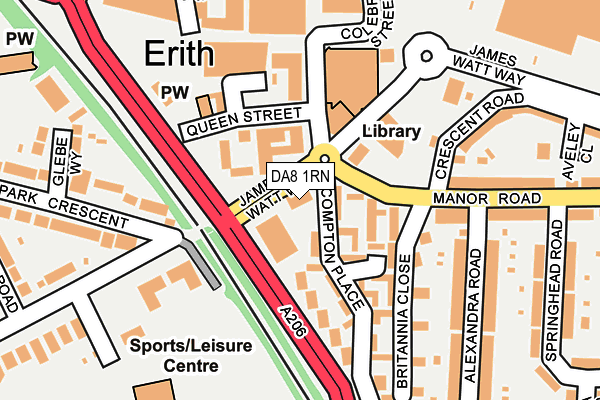
DA8 1RN is located in the Erith electoral ward, within the London borough of Bexley and the English Parliamentary constituency of Erith and Thamesmead. The Sub Integrated Care Board (ICB) Location is NHS South East London ICB - 72Q and the police force is Metropolitan Police. This postcode has been in use since January 1980.


GetTheData
Source: OS OpenMap – Local (Ordnance Survey)
Source: OS VectorMap District (Ordnance Survey)
Licence: Open Government Licence (requires attribution)
| Easting | 551540 |
| Northing | 177750 |
| Latitude | 51.478415 |
| Longitude | 0.180804 |
GetTheData
Source: Open Postcode Geo
Licence: Open Government Licence
| Country | England |
| Postcode District | DA8 |
| ➜ DA8 open data dashboard ➜ See where DA8 is on a map ➜ Where is Erith? | |
GetTheData
Source: Land Registry Price Paid Data
Licence: Open Government Licence
Elevation or altitude of DA8 1RN as distance above sea level:
| Metres | Feet | |
|---|---|---|
| Elevation | 10m | 33ft |
Elevation is measured from the approximate centre of the postcode, to the nearest point on an OS contour line from OS Terrain 50, which has contour spacing of ten vertical metres.
➜ How high above sea level am I? Find the elevation of your current position using your device's GPS.
GetTheData
Source: Open Postcode Elevation
Licence: Open Government Licence
| Ward | Erith |
| Constituency | Erith And Thamesmead |
GetTheData
Source: ONS Postcode Database
Licence: Open Government Licence
| January 2024 | Criminal damage and arson | On or near Parking Area | 163m |
| January 2024 | Anti-social behaviour | On or near Parking Area | 274m |
| January 2024 | Public order | On or near Parking Area | 274m |
| ➜ Get more crime data in our Crime section | |||
GetTheData
Source: data.police.uk
Licence: Open Government Licence
| James Watt Way | Erith | 30m |
| Compton Place (Manor Road) | Erith | 88m |
| Erith Health Centre (Erith High Street) | Erith | 120m |
| Colebrook Street | Erith | 211m |
| Erith Town Centre Riverside (Bexley Road) | Erith | 264m |
| Erith Station | 0.5km |
| Slade Green Station | 1.4km |
| Barnehurst Station | 2.1km |
GetTheData
Source: NaPTAN
Licence: Open Government Licence
GetTheData
Source: ONS Postcode Database
Licence: Open Government Licence


➜ Get more ratings from the Food Standards Agency
GetTheData
Source: Food Standards Agency
Licence: FSA terms & conditions
| Last Collection | |||
|---|---|---|---|
| Location | Mon-Fri | Sat | Distance |
| Lesney Park | 17:30 | 11:00 | 529m |
| Beechfield | 17:30 | 11:00 | 559m |
| Park Crescent | 17:30 | 11:00 | 617m |
GetTheData
Source: Dracos
Licence: Creative Commons Attribution-ShareAlike
| Facility | Distance |
|---|---|
| Erith Trades And Social Club (Closed) James Watt Way, Erith Sports Hall | 114m |
| Energie Fitness (Erith) Erith High Street, Erith Health and Fitness Gym | 137m |
| Erith Leisure Centre Avenue Road, Erith Athletics, Health and Fitness Gym, Swimming Pool, Sports Hall, Grass Pitches, Studio, Outdoor Tennis Courts | 267m |
GetTheData
Source: Active Places
Licence: Open Government Licence
| School | Phase of Education | Distance |
|---|---|---|
| Christ Church (Erith) CofE Primary School Lesney Park Road, Erith, DA8 3DG | Primary | 559m |
| Peareswood Primary School Peareswood Road, Erith, DA8 3PR | Primary | 832m |
| Haberdashers' Slade Green Primary Chrome Road, Slade Green, Erith, DA8 2EL | Primary | 918m |
GetTheData
Source: Edubase
Licence: Open Government Licence
The below table lists the International Territorial Level (ITL) codes (formerly Nomenclature of Territorial Units for Statistics (NUTS) codes) and Local Administrative Units (LAU) codes for DA8 1RN:
| ITL 1 Code | Name |
|---|---|
| TLI | London |
| ITL 2 Code | Name |
| TLI5 | Outer London - East and North East |
| ITL 3 Code | Name |
| TLI51 | Bexley and Greenwich |
| LAU 1 Code | Name |
| E09000004 | Bexley |
GetTheData
Source: ONS Postcode Directory
Licence: Open Government Licence
The below table lists the Census Output Area (OA), Lower Layer Super Output Area (LSOA), and Middle Layer Super Output Area (MSOA) for DA8 1RN:
| Code | Name | |
|---|---|---|
| OA | E00001981 | |
| LSOA | E01000403 | Bexley 004A |
| MSOA | E02000068 | Bexley 004 |
GetTheData
Source: ONS Postcode Directory
Licence: Open Government Licence
| DA8 1SQ | James Watt Way | 41m |
| DA8 1RU | Cornelia Place | 89m |
| DA8 1RZ | Compton Place | 107m |
| DA8 1GL | Erith High Street | 115m |
| DA8 1RY | Compton Place | 125m |
| DA8 3BY | Avenue Road | 137m |
| DA8 2AB | Manor Road | 138m |
| DA8 2GQ | Britannia Close | 173m |
| DA8 3BZ | Avenue Road | 175m |
| DA8 2AX | Alexandra Road | 202m |
GetTheData
Source: Open Postcode Geo; Land Registry Price Paid Data
Licence: Open Government Licence