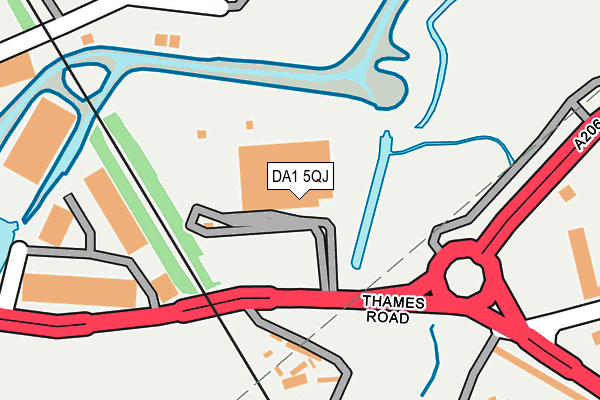
DA1 5QJ is located in the Crayford electoral ward, within the London borough of Bexley and the English Parliamentary constituency of Bexleyheath and Crayford. The Sub Integrated Care Board (ICB) Location is NHS South East London ICB - 72Q and the police force is Metropolitan Police. This postcode has been in use since June 1981.


GetTheData
Source: OS OpenMap – Local (Ordnance Survey)
Source: OS VectorMap District (Ordnance Survey)
Licence: Open Government Licence (requires attribution)
| Easting | 553085 |
| Northing | 175472 |
| Latitude | 51.457532 |
| Longitude | 0.202076 |
GetTheData
Source: Open Postcode Geo
Licence: Open Government Licence
| Country | England |
| Postcode District | DA1 |
| ➜ DA1 open data dashboard ➜ See where DA1 is on a map ➜ Where is London? | |
GetTheData
Source: Land Registry Price Paid Data
Licence: Open Government Licence
Elevation or altitude of DA1 5QJ as distance above sea level:
| Metres | Feet | |
|---|---|---|
| Elevation | 10m | 33ft |
Elevation is measured from the approximate centre of the postcode, to the nearest point on an OS contour line from OS Terrain 50, which has contour spacing of ten vertical metres.
➜ How high above sea level am I? Find the elevation of your current position using your device's GPS.
GetTheData
Source: Open Postcode Elevation
Licence: Open Government Licence
| Ward | Crayford |
| Constituency | Bexleyheath And Crayford |
GetTheData
Source: ONS Postcode Database
Licence: Open Government Licence
| June 2022 | Anti-social behaviour | On or near Sandpit Road | 381m |
| June 2022 | Public order | On or near Shirley Close | 393m |
| June 2022 | Criminal damage and arson | On or near Shirley Close | 393m |
| ➜ Get more crime data in our Crime section | |||
GetTheData
Source: data.police.uk
Licence: Open Government Licence
| Mercedes Garage (Burnham Road) | Dartford | 371m |
| Mill Place | Barnes Cray | 517m |
| Alan Close (Burnham Road) | Dartford | 523m |
| Mayplace Avenue | Barnes Cray | 567m |
| Lawson Road (Burnham Road) | Dartford | 595m |
| Slade Green Station | 1.4km |
| Dartford Station | 1.6km |
| Crayford Station | 1.9km |
GetTheData
Source: NaPTAN
Licence: Open Government Licence
GetTheData
Source: ONS Postcode Database
Licence: Open Government Licence


➜ Get more ratings from the Food Standards Agency
GetTheData
Source: Food Standards Agency
Licence: FSA terms & conditions
| Last Collection | |||
|---|---|---|---|
| Location | Mon-Fri | Sat | Distance |
| Iron Mill Lane | 18:30 | 12:30 | 760m |
| West Hill Schools | 17:30 | 12:00 | 1,189m |
| The Brent | 18:30 | 11:00 | 1,395m |
GetTheData
Source: Dracos
Licence: Creative Commons Attribution-ShareAlike
| Facility | Distance |
|---|---|
| Holy Trinity Church Of England Primary School Chatsworth Road, Dartford Grass Pitches, Athletics | 634m |
| Barnes Cray Primary School (Closed) Iron Mill Lane, Dartford Grass Pitches | 855m |
| Haberdashers' Aske's Crayford Academy Iron Mill Lane, Crayford, Dartford Grass Pitches, Outdoor Tennis Courts, Sports Hall, Studio | 855m |
GetTheData
Source: Active Places
Licence: Open Government Licence
| School | Phase of Education | Distance |
|---|---|---|
| Holy Trinity Church of England Primary School, Dartford Chatsworth Road, Dartford, DA1 5AF | Primary | 638m |
| Haberdashers' Crayford Primary Iron Mill Lane, Crayford, Dartford, DA1 4RS | Primary | 855m |
| West Hill Primary Academy Dartford Road, Dartford, DA1 3DZ | Primary | 1.2km |
GetTheData
Source: Edubase
Licence: Open Government Licence
| Risk of DA1 5QJ flooding from rivers and sea | Very Low |
| ➜ DA1 5QJ flood map | |
GetTheData
Source: Open Flood Risk by Postcode
Licence: Open Government Licence
The below table lists the International Territorial Level (ITL) codes (formerly Nomenclature of Territorial Units for Statistics (NUTS) codes) and Local Administrative Units (LAU) codes for DA1 5QJ:
| ITL 1 Code | Name |
|---|---|
| TLI | London |
| ITL 2 Code | Name |
| TLI5 | Outer London - East and North East |
| ITL 3 Code | Name |
| TLI51 | Bexley and Greenwich |
| LAU 1 Code | Name |
| E09000004 | Bexley |
GetTheData
Source: ONS Postcode Directory
Licence: Open Government Licence
The below table lists the Census Output Area (OA), Lower Layer Super Output Area (LSOA), and Middle Layer Super Output Area (MSOA) for DA1 5QJ:
| Code | Name | |
|---|---|---|
| OA | E00002125 | |
| LSOA | E01000434 | Bexley 008G |
| MSOA | E02000072 | Bexley 008 |
GetTheData
Source: ONS Postcode Directory
Licence: Open Government Licence
| DA1 5AU | Burnham Road | 334m |
| DA1 5HL | Eton Way | 361m |
| DA1 5BU | Invicta Park | 368m |
| DA1 5BB | Shirley Close | 376m |
| DA1 4QH | Thames Road | 381m |
| DA1 5HP | Lagonda Way | 453m |
| DA1 5BA | Burnham Crescent | 468m |
| DA1 5EH | Arundel Road | 478m |
| DA1 5AX | Alan Close | 486m |
| DA1 5AZ | Burnham Road | 517m |
GetTheData
Source: Open Postcode Geo; Land Registry Price Paid Data
Licence: Open Government Licence