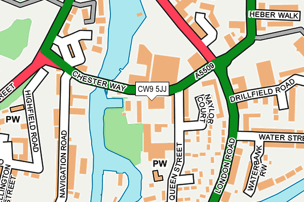
CW9 5JJ is located in the Northwich Leftwich electoral ward, within the unitary authority of Cheshire West and Chester and the English Parliamentary constituency of Weaver Vale. The Sub Integrated Care Board (ICB) Location is NHS Cheshire and Merseyside ICB - 27D and the police force is Cheshire. This postcode has been in use since January 1980.


GetTheData
Source: OS OpenMap – Local (Ordnance Survey)
Source: OS VectorMap District (Ordnance Survey)
Licence: Open Government Licence (requires attribution)
| Easting | 365754 |
| Northing | 373555 |
| Latitude | 53.257886 |
| Longitude | -2.514804 |
GetTheData
Source: Open Postcode Geo
Licence: Open Government Licence
| Country | England |
| Postcode District | CW9 |
| ➜ CW9 open data dashboard ➜ See where CW9 is on a map ➜ Where is Northwich? | |
GetTheData
Source: Land Registry Price Paid Data
Licence: Open Government Licence
Elevation or altitude of CW9 5JJ as distance above sea level:
| Metres | Feet | |
|---|---|---|
| Elevation | 10m | 33ft |
Elevation is measured from the approximate centre of the postcode, to the nearest point on an OS contour line from OS Terrain 50, which has contour spacing of ten vertical metres.
➜ How high above sea level am I? Find the elevation of your current position using your device's GPS.
GetTheData
Source: Open Postcode Elevation
Licence: Open Government Licence
| Ward | Northwich Leftwich |
| Constituency | Weaver Vale |
GetTheData
Source: ONS Postcode Database
Licence: Open Government Licence
| December 2023 | Violence and sexual offences | On or near Beeston Street | 443m |
| December 2023 | Violence and sexual offences | On or near Beeston Street | 443m |
| December 2023 | Violence and sexual offences | On or near Parking Area | 464m |
| ➜ Get more crime data in our Crime section | |||
GetTheData
Source: data.police.uk
Licence: Open Government Licence
| Hayhurst Bridge (Chester Way) | Northwich | 46m |
| Waitrose (Dane Street) | Northwich | 146m |
| Railway Arch (London Road) | Northwich | 283m |
| Railway Arch (London Road) | Northwich | 289m |
| Interchange (Watling Street) | Northwich | 292m |
| Northwich Station | 1.3km |
| Greenbank Station | 1.5km |
| Hartford Station | 3.2km |
GetTheData
Source: NaPTAN
Licence: Open Government Licence
GetTheData
Source: ONS Postcode Database
Licence: Open Government Licence


➜ Get more ratings from the Food Standards Agency
GetTheData
Source: Food Standards Agency
Licence: FSA terms & conditions
| Last Collection | |||
|---|---|---|---|
| Location | Mon-Fri | Sat | Distance |
| Winnington Hill | 17:45 | 11:00 | 403m |
| London Road | 17:30 | 11:00 | 580m |
| Hartford Road | 17:30 | 08:00 | 631m |
GetTheData
Source: Dracos
Licence: Creative Commons Attribution-ShareAlike
| Facility | Distance |
|---|---|
| Inches Fitness Studio (Ladies Only) (Closed) Queen Street, Northwich Health and Fitness Gym | 59m |
| The Drill Field (Northwich Victoria Fc) (Closed) Drill Field Road, Northwich Grass Pitches | 156m |
| Northwich Memorial Court Chester Way, Northwich Swimming Pool, Health and Fitness Gym, Studio, Sports Hall | 439m |
GetTheData
Source: Active Places
Licence: Open Government Licence
| School | Phase of Education | Distance |
|---|---|---|
| Witton Church Walk CofE Aided Nursery and Primary School Church Walk, Northwich, CW9 5QQ | Primary | 588m |
| Charles Darwin Community Primary School Darwin Street, Castle, Northwich, CW8 1BN | Primary | 653m |
| Sir John Deane's Sixth Form College Monarch Drive, Northwich, CW9 8AF | 16 plus | 788m |
GetTheData
Source: Edubase
Licence: Open Government Licence
| Risk of CW9 5JJ flooding from rivers and sea | Low |
| ➜ CW9 5JJ flood map | |
GetTheData
Source: Open Flood Risk by Postcode
Licence: Open Government Licence
The below table lists the International Territorial Level (ITL) codes (formerly Nomenclature of Territorial Units for Statistics (NUTS) codes) and Local Administrative Units (LAU) codes for CW9 5JJ:
| ITL 1 Code | Name |
|---|---|
| TLD | North West (England) |
| ITL 2 Code | Name |
| TLD6 | Cheshire |
| ITL 3 Code | Name |
| TLD63 | Cheshire West and Chester |
| LAU 1 Code | Name |
| E06000050 | Cheshire West and Chester |
GetTheData
Source: ONS Postcode Directory
Licence: Open Government Licence
The below table lists the Census Output Area (OA), Lower Layer Super Output Area (LSOA), and Middle Layer Super Output Area (MSOA) for CW9 5JJ:
| Code | Name | |
|---|---|---|
| OA | E00094482 | |
| LSOA | E01018714 | Cheshire West and Chester 018B |
| MSOA | E02003879 | Cheshire West and Chester 018 |
GetTheData
Source: ONS Postcode Directory
Licence: Open Government Licence
| CW9 5FQ | Chester Way | 54m |
| CW9 5JL | Queen Street | 66m |
| CW9 5JP | Hayhurst Close | 117m |
| CW9 5JS | Naylor Court | 126m |
| CW8 1GL | Freshwater View | 174m |
| CW9 5HG | London Road | 180m |
| CW9 5JN | Queen Street | 182m |
| CW8 1GE | Marine Approach | 189m |
| CW9 5JE | 196m | |
| CW9 5EU | London Road | 199m |
GetTheData
Source: Open Postcode Geo; Land Registry Price Paid Data
Licence: Open Government Licence