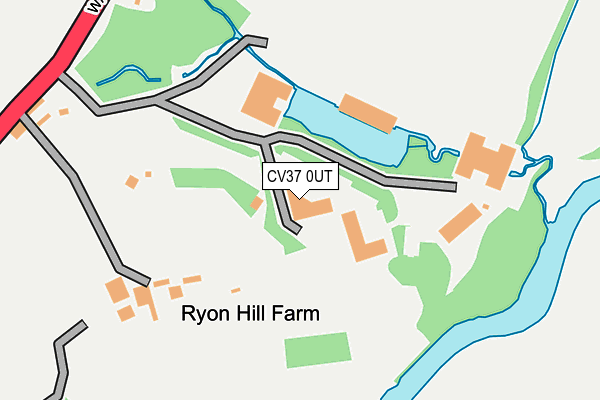
CV37 0UT is located in the Wellesbourne North & Rural electoral ward, within the local authority district of Stratford-on-Avon and the English Parliamentary constituency of Stratford-on-Avon. The Sub Integrated Care Board (ICB) Location is NHS Coventry and Warwickshire ICB - B2M3M and the police force is Warwickshire. This postcode has been in use since June 1999.


GetTheData
Source: OS OpenMap – Local (Ordnance Survey)
Source: OS VectorMap District (Ordnance Survey)
Licence: Open Government Licence (requires attribution)
| Easting | 422487 |
| Northing | 257302 |
| Latitude | 52.213480 |
| Longitude | -1.672302 |
GetTheData
Source: Open Postcode Geo
Licence: Open Government Licence
| Country | England |
| Postcode District | CV37 |
| ➜ CV37 open data dashboard ➜ See where CV37 is on a map | |
GetTheData
Source: Land Registry Price Paid Data
Licence: Open Government Licence
Elevation or altitude of CV37 0UT as distance above sea level:
| Metres | Feet | |
|---|---|---|
| Elevation | 50m | 164ft |
Elevation is measured from the approximate centre of the postcode, to the nearest point on an OS contour line from OS Terrain 50, which has contour spacing of ten vertical metres.
➜ How high above sea level am I? Find the elevation of your current position using your device's GPS.
GetTheData
Source: Open Postcode Elevation
Licence: Open Government Licence
| Ward | Wellesbourne North & Rural |
| Constituency | Stratford-on-avon |
GetTheData
Source: ONS Postcode Database
Licence: Open Government Licence
| July 2023 | Public order | On or near Park/Open Space | 84m |
| February 2021 | Violence and sexual offences | On or near Warwick Road | 217m |
| February 2021 | Violence and sexual offences | On or near Warwick Road | 217m |
| ➜ Get more crime data in our Crime section | |||
GetTheData
Source: data.police.uk
Licence: Open Government Licence
| Ryon Hill (Warwick Road) | Stratford-upon-avon | 298m |
| Ryon Hill (Warwick Road) | Stratford-upon-avon | 315m |
| Hatton Rock Farm (Stratford Road) | Hatton Rock | 842m |
| Hatton Rock Farm (Stratford Road) | Hatton Rock | 860m |
| Church (Church Road) | Alveston | 1,154m |
| Stratford-upon-Avon Station | 3.7km |
| Stratford-upon-Avon Parkway Station | 4.1km |
GetTheData
Source: NaPTAN
Licence: Open Government Licence
GetTheData
Source: ONS Postcode Database
Licence: Open Government Licence


➜ Get more ratings from the Food Standards Agency
GetTheData
Source: Food Standards Agency
Licence: FSA terms & conditions
| Last Collection | |||
|---|---|---|---|
| Location | Mon-Fri | Sat | Distance |
| Hatton Rock | 17:00 | 08:30 | 861m |
| Ingon Lane | 17:00 | 07:00 | 905m |
| Lower End | 16:30 | 08:30 | 1,064m |
GetTheData
Source: Dracos
Licence: Creative Commons Attribution-ShareAlike
| Facility | Distance |
|---|---|
| Stratford Park Hotel & Golf Club Ingon Lane, Stratford-upon-avon Golf | 1.3km |
| Homeguard Club Main Street, Tiddington Grass Pitches, Cycling | 1.4km |
| Stratford-upon-avon Athletics Club Running Track (Closed) Main Street, Tiddington, Stratford-upon-avon Athletics | 1.5km |
GetTheData
Source: Active Places
Licence: Open Government Licence
| School | Phase of Education | Distance |
|---|---|---|
| Alveston CofE Primary School Knights Lane, Tiddington, Stratford-upon-Avon, CV37 7BZ | Primary | 2km |
| The Croft Preparatory School Alveston Hill, Loxley Road, Stratford-upon-Avon, CV37 7RL | Not applicable | 2.6km |
| Welcombe Hills School Blue Cap Road, Stratford-upon-Avon, CV37 6TQ | Not applicable | 2.6km |
GetTheData
Source: Edubase
Licence: Open Government Licence
The below table lists the International Territorial Level (ITL) codes (formerly Nomenclature of Territorial Units for Statistics (NUTS) codes) and Local Administrative Units (LAU) codes for CV37 0UT:
| ITL 1 Code | Name |
|---|---|
| TLG | West Midlands (England) |
| ITL 2 Code | Name |
| TLG1 | Herefordshire, Worcestershire and Warwickshire |
| ITL 3 Code | Name |
| TLG13 | Warwickshire CC |
| LAU 1 Code | Name |
| E07000221 | Stratford-on-Avon |
GetTheData
Source: ONS Postcode Directory
Licence: Open Government Licence
The below table lists the Census Output Area (OA), Lower Layer Super Output Area (LSOA), and Middle Layer Super Output Area (MSOA) for CV37 0UT:
| Code | Name | |
|---|---|---|
| OA | E00159157 | |
| LSOA | E01031218 | Stratford-on-Avon 008B |
| MSOA | E02006511 | Stratford-on-Avon 008 |
GetTheData
Source: ONS Postcode Directory
Licence: Open Government Licence
| CV37 0NZ | Warwick Road | 169m |
| CV37 0NX | Packsaddle Hill | 466m |
| CV37 0NT | Warwick Road | 656m |
| CV37 0NU | 883m | |
| CV37 7QL | Mill Lane | 885m |
| CV37 7QF | Alveston Lane | 956m |
| CV37 0QE | Ingon Lane | 958m |
| CV37 7QN | Alveston Leys | 1047m |
| CV37 7QH | Lower End | 1053m |
| CV37 0PZ | Warwick Road | 1098m |
GetTheData
Source: Open Postcode Geo; Land Registry Price Paid Data
Licence: Open Government Licence