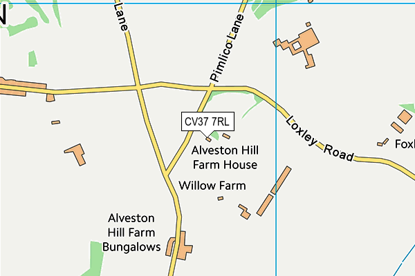
The Croft Preparatory School is located in Loxley Road, Stratford-upon-Avon and falls under the local authority of Warwickshire. The school's religious denomination is Christian. This mixed-sex school has 374 pupils, with a capacity of 500, aged from three up to eleven, and the type of establishment is other independent school.
| Address | The Croft Preparatory School Alveston Hill Loxley Road Stratford-upon-Avon Warwickshire CV37 7RL |
| Website | http://www.croftschool.co.uk |
| Headmaster | Mr Marcus Cook |
GetTheData
Source: Get Information About Schools
Licence: Open Government Licence
| Phase of Education | Not applicable |
| Type of Establishment | Other independent school |
| Admissions Policy | Not applicable |
| Statutory Low Age | 3 |
| Statutory High Age | 11 |
| Boarders | No boarders |
| Boarding Establishment | Does not have boarders |
| Official Sixth Form | Does not have a sixth form |
| Gender | Mixed |
| Religious Character | Christian |
| Diocese | Not applicable |
| Special Classes | No Special Classes |
GetTheData
Source: Get Information About Schools
Licence: Open Government Licence
| Census Date | 20th January 2022 | |
| School Capacity | 500 | |
| Number of Pupils | 374 | 75% capacity |
| Number of Boys | 192 | 51% |
| Number of Girls | 182 | 49% |
GetTheData
Source: Get Information About Schools
Licence: Open Government Licence
| Street Address | Alveston Hill |
| Locality | Loxley Road |
| Town | Stratford-upon-Avon |
| County | Warwickshire |
| Postcode | CV37 7RL |
| ➜ More CV37 7RL open data | |
GetTheData
Source: Get Information About Schools
Licence: Open Government Licence

GetTheData
Source: OS VectorMap District (Ordnance Survey)
Licence: Open Government Licence (requires attribution)
| Ofsted Special Measures | Not applicable |
GetTheData
Source: Get Information About Schools
Licence: Open Government Licence
| Establishment Name | The Croft Preparatory School |
| Establishment Number | 6016 |
| Unique Reference Number | 125778 |
| Local Authority | Warwickshire |
| Local Authority Code | 937 |
| Previous Local Authority Code | 999 |
| Government Statistical Service Local Authority Code | E10000031 |
| Government Office Region | West Midlands |
| District | Stratford-on-Avon |
| District Code | E07000221 |
| Ward | Stratford Tiddington |
| Parliamentary Constituency | Stratford-on-Avon |
| Urban/Rural Description | (England/Wales) Urban city and town |
| Middle Super Output Area | Stratford-on-Avon 010 |
| Lower Super Output Area | Stratford-on-Avon 010E |
GetTheData
Source: Get Information About Schools
Licence: Open Government Licence
| Establishment Status | Open |
| Last Changed Date | 10th January 2024 |
| Reason Establishment Opened | Not applicable |
| Open Date | 1st January 1951 |
| Reason Establishment Closed | Not applicable |
GetTheData
Source: Get Information About Schools
Licence: Open Government Licence
| Teenage Mothers | Not applicable |
| Child Care Facilities | Not applicable |
| Special Educational Needs (SEN) Provision in Primary Care Unit | Not applicable |
| Pupil Referral Unit (PRU) Provides for Educational and Behavioural Difficulties (EBD) | Not applicable |
| Pupil Referral Unit (PRU) Offers Tuition by Another Provider | Not applicable |
GetTheData
Source: Get Information About Schools
Licence: Open Government Licence
| Section 41 Approved | Not approved |
GetTheData
Source: Get Information About Schools
Licence: Open Government Licence
| Trust flag | Not applicable |
| School Sponsor flag | Not applicable |
GetTheData
Source: Get Information About Schools
Licence: Open Government Licence
| Federation flag | Not applicable |
GetTheData
Source: Get Information About Schools
Licence: Open Government Licence
| UK Provider Reference Number | 10071085 |
| Further Education Type | Not applicable |
GetTheData
Source: Get Information About Schools
Licence: Open Government Licence
| Easting | 423125 |
| Northing | 254790 |
| Latitude | 52.19087 |
| Longitude | -1.66314 |
GetTheData
Source: Get Information About Schools
Licence: Open Government Licence
| School | Phase of Education | Distance |
|---|---|---|
| Alveston CofE Primary School Knights Lane, Tiddington, Stratford-upon-Avon, CV37 7BZ | Primary | 1.1km |
| Bridgetown Primary School Byron Road, Stratford-upon-Avon, CV37 7JP | Primary | 2.2km |
| St Gregory's Catholic Primary School Avenue Road, Stratford-upon-Avon, CV37 6UZ | Primary | 2.9km |
| King Edward VI School Chapel Lane, Stratford-upon-Avon, CV37 6BE | Secondary | 3km |
| Stratford Preparatory School Church House, Old Town, Church House, Stratford-upon-Avon, CV37 6BG | Not applicable | 3.2km |
| Welcombe Hills School Blue Cap Road, Stratford-upon-Avon, CV37 6TQ | Not applicable | 3.3km |
| Loxley CofE Community Primary School Loxley, Warwick, CV35 9JT | Primary | 3.3km |
| Thomas Jolyffe Primary School Clopton Road, Stratford-upon-Avon, CV37 6TE | Primary | 3.3km |
| Stratford-Upon-Avon Primary School Broad Street, Stratford-upon-Avon, CV37 6HN | Primary | 3.3km |
| Hampton Lucy CofE Primary School Church Street, Hampton Lucy, Warwick, CV35 8BE | Primary | 3.4km |
GetTheData
Source: Get Information About Schools
Licence: Open Government Licence