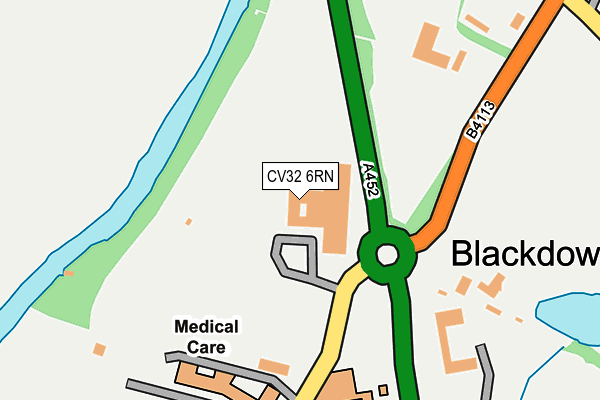
CV32 6RN lies on Old Milverton Lane in Leamington Spa. CV32 6RN is located in the Leamington Milverton electoral ward, within the local authority district of Warwick and the English Parliamentary constituency of Kenilworth and Southam. The Sub Integrated Care Board (ICB) Location is NHS Coventry and Warwickshire ICB - B2M3M and the police force is Warwickshire. This postcode has been in use since January 1980.


GetTheData
Source: OS OpenMap – Local (Ordnance Survey)
Source: OS VectorMap District (Ordnance Survey)
Licence: Open Government Licence (requires attribution)
| Easting | 431398 |
| Northing | 268406 |
| Latitude | 52.312871 |
| Longitude | -1.540857 |
GetTheData
Source: Open Postcode Geo
Licence: Open Government Licence
| Street | Old Milverton Lane |
| Town/City | Leamington Spa |
| Country | England |
| Postcode District | CV32 |
| ➜ CV32 open data dashboard ➜ See where CV32 is on a map ➜ Where is Blackdown? | |
GetTheData
Source: Land Registry Price Paid Data
Licence: Open Government Licence
Elevation or altitude of CV32 6RN as distance above sea level:
| Metres | Feet | |
|---|---|---|
| Elevation | 60m | 197ft |
Elevation is measured from the approximate centre of the postcode, to the nearest point on an OS contour line from OS Terrain 50, which has contour spacing of ten vertical metres.
➜ How high above sea level am I? Find the elevation of your current position using your device's GPS.
GetTheData
Source: Open Postcode Elevation
Licence: Open Government Licence
| Ward | Leamington Milverton |
| Constituency | Kenilworth And Southam |
GetTheData
Source: ONS Postcode Database
Licence: Open Government Licence
| June 2022 | Violence and sexual offences | On or near Stoneleigh Road | 193m |
| May 2022 | Criminal damage and arson | On or near Stoneleigh Road | 193m |
| May 2022 | Vehicle crime | On or near Stoneleigh Road | 193m |
| ➜ Get more crime data in our Crime section | |||
GetTheData
Source: data.police.uk
Licence: Open Government Licence
| Blackdown Crossroads (Kenilworth Road) | Leamington Spa | 83m |
| Blackdown Crossorads (Kenilworth Road) | Leamington Spa | 166m |
| Oak Bank House (Kenilworth Road) | Leamington Spa | 503m |
| Leamington Rugby Club (Kenilworth Road) | Hill Wootton | 768m |
| Alan Browne Garages (Kenilworth Road) | Hill Wootton | 800m |
| Leamington Spa Station | 3.2km |
| Warwick Station | 4km |
| Warwick Parkway Station | 5.7km |
GetTheData
Source: NaPTAN
Licence: Open Government Licence
GetTheData
Source: ONS Postcode Database
Licence: Open Government Licence


➜ Get more ratings from the Food Standards Agency
GetTheData
Source: Food Standards Agency
Licence: FSA terms & conditions
| Last Collection | |||
|---|---|---|---|
| Location | Mon-Fri | Sat | Distance |
| Blackdown Mill | 16:30 | 07:00 | 823m |
| Lime Avenue | 16:00 | 12:00 | 1,067m |
| Northumberland Court | 16:00 | 12:00 | 1,097m |
GetTheData
Source: Dracos
Licence: Creative Commons Attribution-ShareAlike
| Facility | Distance |
|---|---|
| The Kingsley School Playing Fields Sandy Lane, Blackdown, Leamington Spa Outdoor Tennis Courts, Grass Pitches | 488m |
| Leamington Rugby Club Kenilworth Road, Blackdown, Leamington Spa Grass Pitches, Health and Fitness Gym | 647m |
| North Leamington School Sandy Lane, Blackdown, Leamington Spa Sports Hall, Artificial Grass Pitch, Health and Fitness Gym, Grass Pitches, Studio, Outdoor Tennis Courts | 800m |
GetTheData
Source: Active Places
Licence: Open Government Licence
| School | Phase of Education | Distance |
|---|---|---|
| North Leamington School Sandy Lane, Blackdown, Leamington Spa, CV32 6RD | Secondary | 825m |
| Telford Junior School Telford Avenue, Lillington, Leamington Spa, CV32 7HP | Primary | 1.4km |
| Telford Infant School Kelvin Road, Lillington, Leamington Spa, CV32 7TE | Primary | 1.6km |
GetTheData
Source: Edubase
Licence: Open Government Licence
The below table lists the International Territorial Level (ITL) codes (formerly Nomenclature of Territorial Units for Statistics (NUTS) codes) and Local Administrative Units (LAU) codes for CV32 6RN:
| ITL 1 Code | Name |
|---|---|
| TLG | West Midlands (England) |
| ITL 2 Code | Name |
| TLG1 | Herefordshire, Worcestershire and Warwickshire |
| ITL 3 Code | Name |
| TLG13 | Warwickshire CC |
| LAU 1 Code | Name |
| E07000222 | Warwick |
GetTheData
Source: ONS Postcode Directory
Licence: Open Government Licence
The below table lists the Census Output Area (OA), Lower Layer Super Output Area (LSOA), and Middle Layer Super Output Area (MSOA) for CV32 6RN:
| Code | Name | |
|---|---|---|
| OA | E00159496 | |
| LSOA | E01031278 | Warwick 005B |
| MSOA | E02006523 | Warwick 005 |
GetTheData
Source: ONS Postcode Directory
Licence: Open Government Licence
| CV32 6RE | Stoneleigh Road | 182m |
| CV32 6RG | Kenilworth Road | 318m |
| CV32 6QS | Sandy Lane | 418m |
| CV32 6RW | 469m | |
| CV32 6RD | Sandy Lane | 542m |
| CV32 6QR | Stoneleigh Road | 739m |
| CV32 6QN | 780m | |
| CV32 6RH | Brightsmith Way | 834m |
| CV32 6HU | Burman Close | 871m |
| CV32 6NX | Crowden Drive | 879m |
GetTheData
Source: Open Postcode Geo; Land Registry Price Paid Data
Licence: Open Government Licence