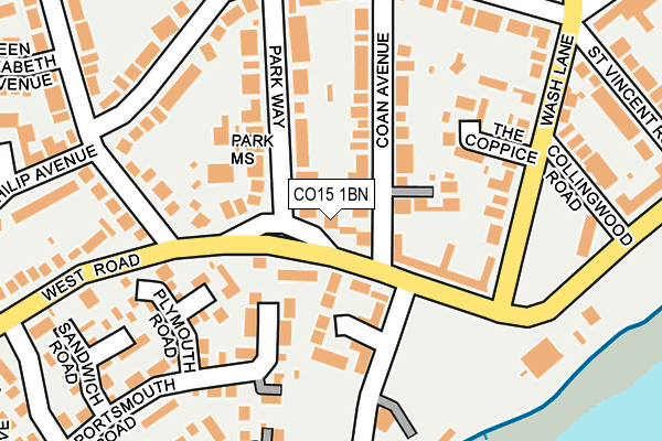
CO15 1BN lies on West Road in Clacton-on-sea. CO15 1BN is located in the St James electoral ward, within the local authority district of Tendring and the English Parliamentary constituency of Clacton. The Sub Integrated Care Board (ICB) Location is NHS Suffolk and North East Essex ICB - 06T and the police force is Essex. This postcode has been in use since July 1986.


GetTheData
Source: OS OpenMap – Local (Ordnance Survey)
Source: OS VectorMap District (Ordnance Survey)
Licence: Open Government Licence (requires attribution)
| Easting | 616727 |
| Northing | 214057 |
| Latitude | 51.783181 |
| Longitude | 1.140677 |
GetTheData
Source: Open Postcode Geo
Licence: Open Government Licence
| Street | West Road |
| Town/City | Clacton-on-sea |
| Country | England |
| Postcode District | CO15 |
| ➜ CO15 open data dashboard ➜ See where CO15 is on a map ➜ Where is Clacton-on-Sea? | |
GetTheData
Source: Land Registry Price Paid Data
Licence: Open Government Licence
Elevation or altitude of CO15 1BN as distance above sea level:
| Metres | Feet | |
|---|---|---|
| Elevation | 10m | 33ft |
Elevation is measured from the approximate centre of the postcode, to the nearest point on an OS contour line from OS Terrain 50, which has contour spacing of ten vertical metres.
➜ How high above sea level am I? Find the elevation of your current position using your device's GPS.
GetTheData
Source: Open Postcode Elevation
Licence: Open Government Licence
| Ward | St James |
| Constituency | Clacton |
GetTheData
Source: ONS Postcode Database
Licence: Open Government Licence
| December 2023 | Violence and sexual offences | On or near Parking Area | 178m |
| November 2023 | Violence and sexual offences | On or near Parking Area | 172m |
| November 2023 | Violence and sexual offences | On or near Parking Area | 178m |
| ➜ Get more crime data in our Crime section | |||
GetTheData
Source: data.police.uk
Licence: Open Government Licence
| Coan Avenue (West Road) | Clacton | 92m |
| Queens Road (West Road) | Clacton | 137m |
| Martello Inn (Marine Parade West) | Clacton | 191m |
| Queens Road (West Road) | Clacton | 216m |
| Martello Inn (Marine Parade West) | Clacton | 241m |
| Clacton-on-Sea Station | 1.5km |
GetTheData
Source: NaPTAN
Licence: Open Government Licence
| Percentage of properties with Next Generation Access | 100.0% |
| Percentage of properties with Superfast Broadband | 100.0% |
| Percentage of properties with Ultrafast Broadband | 0.0% |
| Percentage of properties with Full Fibre Broadband | 0.0% |
Superfast Broadband is between 30Mbps and 300Mbps
Ultrafast Broadband is > 300Mbps
| Percentage of properties unable to receive 2Mbps | 0.0% |
| Percentage of properties unable to receive 5Mbps | 0.0% |
| Percentage of properties unable to receive 10Mbps | 0.0% |
| Percentage of properties unable to receive 30Mbps | 0.0% |
GetTheData
Source: Ofcom
Licence: Ofcom Terms of Use (requires attribution)
GetTheData
Source: ONS Postcode Database
Licence: Open Government Licence


➜ Get more ratings from the Food Standards Agency
GetTheData
Source: Food Standards Agency
Licence: FSA terms & conditions
| Last Collection | |||
|---|---|---|---|
| Location | Mon-Fri | Sat | Distance |
| Wash Lane | 17:00 | 11:00 | 174m |
| Uplands Road | 17:15 | 11:00 | 218m |
| Hastings Avenue | 17:00 | 11:00 | 330m |
GetTheData
Source: Dracos
Licence: Creative Commons Attribution-ShareAlike
| Facility | Distance |
|---|---|
| Clacton-on-sea Golf Club Ltd West Road, Clacton-on-sea Golf | 487m |
| Alton Park Junior School Leas Road, Clacton-on-sea Grass Pitches | 779m |
| The Brotherhood Institute St. Osyth Road, Clacton-on-sea Sports Hall | 1.2km |
GetTheData
Source: Active Places
Licence: Open Government Licence
| School | Phase of Education | Distance |
|---|---|---|
| Alton Park Junior School Alton Park Road, Clacton-on-Sea, CO15 1DL | Primary | 779m |
| Oakwood Infant and Nursery School Windsor Avenue, Clacton-on-Sea, CO15 2AH | Primary | 896m |
| Sir Martin Frobisher Academy Frobisher Drive, Jaywick, Clacton-on-Sea, CO15 2QH | Primary | 1.8km |
GetTheData
Source: Edubase
Licence: Open Government Licence
| Risk of CO15 1BN flooding from rivers and sea | Low |
| ➜ CO15 1BN flood map | |
GetTheData
Source: Open Flood Risk by Postcode
Licence: Open Government Licence
The below table lists the International Territorial Level (ITL) codes (formerly Nomenclature of Territorial Units for Statistics (NUTS) codes) and Local Administrative Units (LAU) codes for CO15 1BN:
| ITL 1 Code | Name |
|---|---|
| TLH | East |
| ITL 2 Code | Name |
| TLH3 | Essex |
| ITL 3 Code | Name |
| TLH34 | Essex Haven Gateway |
| LAU 1 Code | Name |
| E07000076 | Tendring |
GetTheData
Source: ONS Postcode Directory
Licence: Open Government Licence
The below table lists the Census Output Area (OA), Lower Layer Super Output Area (LSOA), and Middle Layer Super Output Area (MSOA) for CO15 1BN:
| Code | Name | |
|---|---|---|
| OA | E00111966 | |
| LSOA | E01022037 | Tendring 017D |
| MSOA | E02004589 | Tendring 017 |
GetTheData
Source: ONS Postcode Directory
Licence: Open Government Licence
| CO15 1AY | Spinnaker Close | 91m |
| CO15 1AH | West Road | 109m |
| CO15 1XQ | Hythe Close | 115m |
| CO15 1BH | Coan Avenue | 116m |
| CO15 1BL | West Road | 120m |
| CO15 1BJ | Park Way | 129m |
| CO15 1HY | The Coppice | 135m |
| CO15 1UN | Wash Lane | 149m |
| CO15 1BP | Portsmouth Road | 160m |
| CO15 1XG | Plymouth Road | 179m |
GetTheData
Source: Open Postcode Geo; Land Registry Price Paid Data
Licence: Open Government Licence