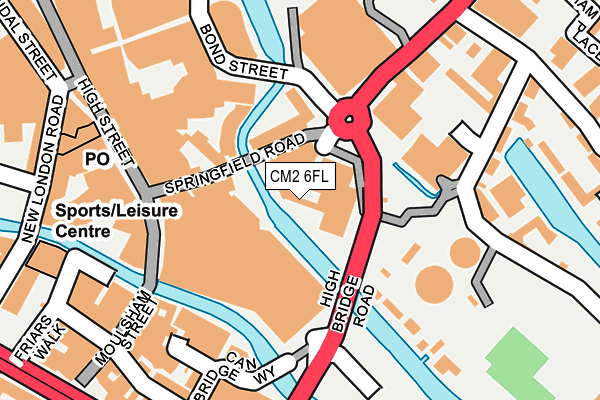
CM2 6FL is located in the Moulsham and Central electoral ward, within the local authority district of Chelmsford and the English Parliamentary constituency of Chelmsford. The Sub Integrated Care Board (ICB) Location is NHS Mid and South Essex ICB - 06Q and the police force is Essex. This postcode has been in use since July 1995.


GetTheData
Source: OS OpenMap – Local (Ordnance Survey)
Source: OS VectorMap District (Ordnance Survey)
Licence: Open Government Licence (requires attribution)
| Easting | 571144 |
| Northing | 206628 |
| Latitude | 51.732245 |
| Longitude | 0.476946 |
GetTheData
Source: Open Postcode Geo
Licence: Open Government Licence
| Country | England |
| Postcode District | CM2 |
| ➜ CM2 open data dashboard ➜ See where CM2 is on a map ➜ Where is Chelmsford? | |
GetTheData
Source: Land Registry Price Paid Data
Licence: Open Government Licence
Elevation or altitude of CM2 6FL as distance above sea level:
| Metres | Feet | |
|---|---|---|
| Elevation | 30m | 98ft |
Elevation is measured from the approximate centre of the postcode, to the nearest point on an OS contour line from OS Terrain 50, which has contour spacing of ten vertical metres.
➜ How high above sea level am I? Find the elevation of your current position using your device's GPS.
GetTheData
Source: Open Postcode Elevation
Licence: Open Government Licence
| Ward | Moulsham And Central |
| Constituency | Chelmsford |
GetTheData
Source: ONS Postcode Database
Licence: Open Government Licence
| January 2024 | Public order | On or near Parking Area | 180m |
| January 2024 | Violence and sexual offences | On or near Parking Area | 313m |
| January 2024 | Criminal damage and arson | On or near Rochford Road | 360m |
| ➜ Get more crime data in our Crime section | |||
GetTheData
Source: data.police.uk
Licence: Open Government Licence
| Town Centre Tesco Store (Springfield Road) | Chelmsford | 151m |
| Town Centre Tesco Store (Springfield Road) | Chelmsford | 176m |
| H & M (New London Road) | Chelmsford City Centre | 253m |
| Wharf Road (Navigation Road) | Chelmsford | 254m |
| Reed Agency (New London Road) | Chelmsford City Centre | 254m |
| Chelmsford Station | 0.7km |
GetTheData
Source: NaPTAN
Licence: Open Government Licence
GetTheData
Source: ONS Postcode Database
Licence: Open Government Licence


➜ Get more ratings from the Food Standards Agency
GetTheData
Source: Food Standards Agency
Licence: FSA terms & conditions
| Last Collection | |||
|---|---|---|---|
| Location | Mon-Fri | Sat | Distance |
| Meadows Shopping Centre | 16:45 | 12:30 | 84m |
| Tesco | 18:00 | 12:30 | 115m |
| High Street | 17:45 | 12:45 | 220m |
GetTheData
Source: Dracos
Licence: Creative Commons Attribution-ShareAlike
| Facility | Distance |
|---|---|
| Puregym (Chelmsford Meadows) High Bridge Road , Chelmsford Health and Fitness Gym | 44m |
| The Gym Group (Chelmsford) New London Road, Chelmsford Health and Fitness Gym | 260m |
| Riverside Leisure Centre (Chelmsford) Victoria Road, Victoria Road, Chelmsford Sports Hall, Ice Rinks, Swimming Pool, Health and Fitness Gym, Studio | 388m |
GetTheData
Source: Active Places
Licence: Open Government Licence
| School | Phase of Education | Distance |
|---|---|---|
| The Cathedral Church of England Voluntary Aided Primary School, Chelmsford Victoria Road, The Cathedral C of E primary, Chelmsford, CM1 1PA | Primary | 472m |
| Trinity Road Primary School Trinity Road, Chelmsford, CM2 6HS | Primary | 663m |
| Our Lady Immaculate Catholic Primary School New London Road, Chelmsford, CM2 0RG | Primary | 754m |
GetTheData
Source: Edubase
Licence: Open Government Licence
| Risk of CM2 6FL flooding from rivers and sea | Low |
| ➜ CM2 6FL flood map | |
GetTheData
Source: Open Flood Risk by Postcode
Licence: Open Government Licence
The below table lists the International Territorial Level (ITL) codes (formerly Nomenclature of Territorial Units for Statistics (NUTS) codes) and Local Administrative Units (LAU) codes for CM2 6FL:
| ITL 1 Code | Name |
|---|---|
| TLH | East |
| ITL 2 Code | Name |
| TLH3 | Essex |
| ITL 3 Code | Name |
| TLH36 | Heart of Essex |
| LAU 1 Code | Name |
| E07000070 | Chelmsford |
GetTheData
Source: ONS Postcode Directory
Licence: Open Government Licence
The below table lists the Census Output Area (OA), Lower Layer Super Output Area (LSOA), and Middle Layer Super Output Area (MSOA) for CM2 6FL:
| Code | Name | |
|---|---|---|
| OA | E00170981 | |
| LSOA | E01033140 | Chelmsford 010F |
| MSOA | E02004494 | Chelmsford 010 |
GetTheData
Source: ONS Postcode Directory
Licence: Open Government Licence
| CM2 6FD | The Meadows | 93m |
| CM1 1FU | Meadow Walk | 145m |
| CM1 1DH | High Street | 169m |
| CM2 6JY | Springfield Road | 170m |
| CM2 0HR | Moulsham Street | 196m |
| CM2 6HZ | Navigation Road | 197m |
| CM2 6YQ | Springfield Basin | 204m |
| CM2 6LU | Wharf Road | 210m |
| CM2 6HU | Coates Quay | 240m |
| CM2 0DG | Baddow Road | 250m |
GetTheData
Source: Open Postcode Geo; Land Registry Price Paid Data
Licence: Open Government Licence