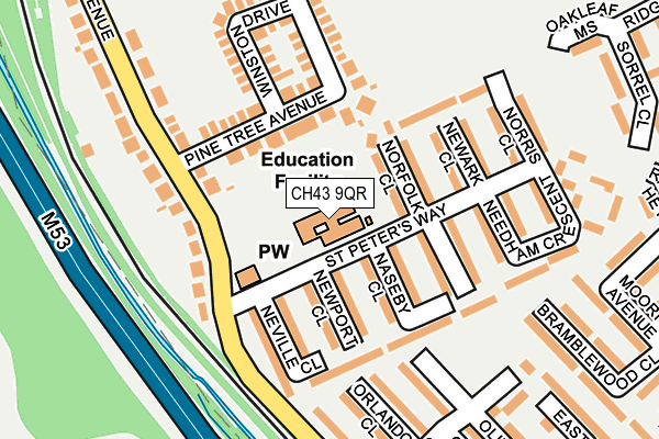
CH43 9QR is located in the Claughton electoral ward, within the metropolitan district of Wirral and the English Parliamentary constituency of Birkenhead. The Sub Integrated Care Board (ICB) Location is NHS Cheshire and Merseyside ICB - 12F and the police force is Merseyside. This postcode has been in use since June 1999.


GetTheData
Source: OS OpenMap – Local (Ordnance Survey)
Source: OS VectorMap District (Ordnance Survey)
Licence: Open Government Licence (requires attribution)
| Easting | 328320 |
| Northing | 387900 |
| Latitude | 53.383062 |
| Longitude | -3.079104 |
GetTheData
Source: Open Postcode Geo
Licence: Open Government Licence
| Country | England |
| Postcode District | CH43 |
| ➜ CH43 open data dashboard ➜ See where CH43 is on a map ➜ Where is Birkenhead? | |
GetTheData
Source: Land Registry Price Paid Data
Licence: Open Government Licence
Elevation or altitude of CH43 9QR as distance above sea level:
| Metres | Feet | |
|---|---|---|
| Elevation | 10m | 33ft |
Elevation is measured from the approximate centre of the postcode, to the nearest point on an OS contour line from OS Terrain 50, which has contour spacing of ten vertical metres.
➜ How high above sea level am I? Find the elevation of your current position using your device's GPS.
GetTheData
Source: Open Postcode Elevation
Licence: Open Government Licence
| Ward | Claughton |
| Constituency | Birkenhead |
GetTheData
Source: ONS Postcode Database
Licence: Open Government Licence
| November 2023 | Violence and sexual offences | On or near Noctorum Avenue | 108m |
| November 2023 | Violence and sexual offences | On or near Noctorum Avenue | 108m |
| August 2023 | Violence and sexual offences | On or near Noctorum Avenue | 108m |
| ➜ Get more crime data in our Crime section | |||
GetTheData
Source: data.police.uk
Licence: Open Government Licence
| St Peters Way (Noctorum Avenue) | Noctorum | 129m |
| St Peters Way (Noctorum Avenue) | Noctorum | 178m |
| Beryl Road (Noctorum Avenue) | Noctorum | 272m |
| Beryl Road (Noctorum Avenue) | Noctorum | 291m |
| Ormond Way (Noctorum Avenue) | Noctorum | 298m |
| Upton Station | 0.5km |
| Birkenhead North Station | 2.8km |
| Bidston Station | 2.9km |
GetTheData
Source: NaPTAN
Licence: Open Government Licence
GetTheData
Source: ONS Postcode Database
Licence: Open Government Licence


➜ Get more ratings from the Food Standards Agency
GetTheData
Source: Food Standards Agency
Licence: FSA terms & conditions
| Last Collection | |||
|---|---|---|---|
| Location | Mon-Fri | Sat | Distance |
| Beresford Road | 17:00 | 12:00 | 1,919m |
| Alton Road | 17:30 | 12:00 | 2,069m |
| Sandbrook Lane | 17:30 | 12:00 | 2,248m |
GetTheData
Source: Dracos
Licence: Creative Commons Attribution-ShareAlike
| Facility | Distance |
|---|---|
| St Anselms College Playing Fields Beryl Road, Noctorum, Prenton Grass Pitches | 321m |
| Woodchurch Leisure Centre (Closed) Carr Bridge Road, Wirral Swimming Pool, Sports Hall, Grass Pitches, Athletics | 394m |
| Ridgeway High School Noctorum Avenue, Prenton Grass Pitches, Sports Hall, Studio | 526m |
GetTheData
Source: Active Places
Licence: Open Government Licence
| School | Phase of Education | Distance |
|---|---|---|
| St Peter's Catholic Primary School St Peter's Way, Noctorum, St. Peters Rc Primary School, Prenton, CH43 9QR | Primary | 4m |
| Co-Op Academy Hillside Ridgeview Road, Prenton, CH43 9HG | Primary | 384m |
| Ridgeway High School Noctorum Avenue, Noctorum, Prenton, CH43 9EB | Secondary | 500m |
GetTheData
Source: Edubase
Licence: Open Government Licence
The below table lists the International Territorial Level (ITL) codes (formerly Nomenclature of Territorial Units for Statistics (NUTS) codes) and Local Administrative Units (LAU) codes for CH43 9QR:
| ITL 1 Code | Name |
|---|---|
| TLD | North West (England) |
| ITL 2 Code | Name |
| TLD7 | Merseyside |
| ITL 3 Code | Name |
| TLD74 | Wirral |
| LAU 1 Code | Name |
| E08000015 | Wirral |
GetTheData
Source: ONS Postcode Directory
Licence: Open Government Licence
The below table lists the Census Output Area (OA), Lower Layer Super Output Area (LSOA), and Middle Layer Super Output Area (MSOA) for CH43 9QR:
| Code | Name | |
|---|---|---|
| OA | E00036271 | |
| LSOA | E01007161 | Wirral 019B |
| MSOA | E02001485 | Wirral 019 |
GetTheData
Source: ONS Postcode Directory
Licence: Open Government Licence
| CH43 9SL | Norfolk Close | 63m |
| CH43 9RX | Pine Tree Avenue | 89m |
| CH43 9SU | Naseby Close | 98m |
| CH43 9SY | Newport Close | 100m |
| CH43 9SZ | Neville Close | 115m |
| CH43 9SP | Newark Close | 121m |
| CH43 9ST | Netherfield Close | 133m |
| CH43 9RZ | Noctorum Avenue | 173m |
| CH43 9SR | Norris Close | 176m |
| CH43 9YH | Olivia Mews | 181m |
GetTheData
Source: Open Postcode Geo; Land Registry Price Paid Data
Licence: Open Government Licence