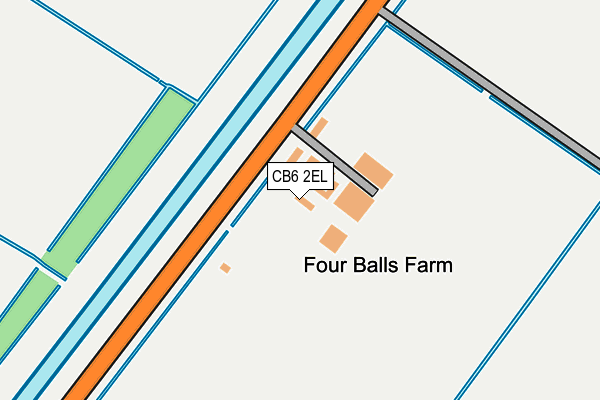
CB6 2EL lies on Hundred Foot Bank in Pymoor, Ely. CB6 2EL is located in the Downham Villages electoral ward, within the local authority district of East Cambridgeshire and the English Parliamentary constituency of North East Cambridgeshire. The Sub Integrated Care Board (ICB) Location is NHS Cambridgeshire and Peterborough ICB - 06H and the police force is Cambridgeshire. This postcode has been in use since January 1980.


GetTheData
Source: OS OpenMap – Local (Ordnance Survey)
Source: OS VectorMap District (Ordnance Survey)
Licence: Open Government Licence (requires attribution)
| Easting | 551919 |
| Northing | 290500 |
| Latitude | 52.491279 |
| Longitude | 0.236181 |
GetTheData
Source: Open Postcode Geo
Licence: Open Government Licence
| Street | Hundred Foot Bank |
| Locality | Pymoor |
| Town/City | Ely |
| Country | England |
| Postcode District | CB6 |
| ➜ CB6 open data dashboard ➜ See where CB6 is on a map | |
GetTheData
Source: Land Registry Price Paid Data
Licence: Open Government Licence
Elevation or altitude of CB6 2EL as distance above sea level:
| Metres | Feet | |
|---|---|---|
| Elevation | 0m | 0ft |
Elevation is measured from the approximate centre of the postcode, to the nearest point on an OS contour line from OS Terrain 50, which has contour spacing of ten vertical metres.
➜ How high above sea level am I? Find the elevation of your current position using your device's GPS.
GetTheData
Source: Open Postcode Elevation
Licence: Open Government Licence
| Ward | Downham Villages |
| Constituency | North East Cambridgeshire |
GetTheData
Source: ONS Postcode Database
Licence: Open Government Licence
| Northfield Farm (Hundred Foot Bank) | Downham | 553m |
| Northfield Farm (Hundred Foot Bank) | Downham | 560m |
| Straight Furlong (Bates's Drove) | Gold Hill | 1,162m |
| Straight Furlong (Bates's Drove) | Gold Hill | 1,169m |
| Manea Station | 4km |
GetTheData
Source: NaPTAN
Licence: Open Government Licence
| Percentage of properties with Next Generation Access | 0.0% |
| Percentage of properties with Superfast Broadband | 0.0% |
| Percentage of properties with Ultrafast Broadband | 0.0% |
| Percentage of properties with Full Fibre Broadband | 0.0% |
Superfast Broadband is between 30Mbps and 300Mbps
Ultrafast Broadband is > 300Mbps
| Percentage of properties unable to receive 2Mbps | 0.0% |
| Percentage of properties unable to receive 5Mbps | 75.0% |
| Percentage of properties unable to receive 10Mbps | 100.0% |
| Percentage of properties unable to receive 30Mbps | 100.0% |
GetTheData
Source: Ofcom
Licence: Ofcom Terms of Use (requires attribution)
GetTheData
Source: ONS Postcode Database
Licence: Open Government Licence
| Last Collection | |||
|---|---|---|---|
| Location | Mon-Fri | Sat | Distance |
| Pumping Engine | 16:30 | 10:00 | 1,750m |
| St Matthews | 16:15 | 07:30 | 2,971m |
| Manea Station | 16:15 | 09:00 | 3,992m |
GetTheData
Source: Dracos
Licence: Creative Commons Attribution-ShareAlike
| Facility | Distance |
|---|---|
| Welney Playing Field Hurn Drove, Welney, Wisbech Grass Pitches, Studio | 3.8km |
| Sm Guy Memorial Playing Field Park Road, Manea Grass Pitches | 4.1km |
| Pyemoor Recreation Ground Pymore Lane, Pymoor, Ely Grass Pitches | 4.5km |
GetTheData
Source: Active Places
Licence: Open Government Licence
| School | Phase of Education | Distance |
|---|---|---|
| Manea Community Primary School Station Road, Manea, PE15 0HA | Primary | 4km |
| Vista Academy Littleport Camel Road, Ely, CB6 1EW | Secondary | 5.1km |
| Highfield Littleport Academy Elmside, Ely, CB6 1LJ | Not applicable | 5.1km |
GetTheData
Source: Edubase
Licence: Open Government Licence
| Risk of CB6 2EL flooding from rivers and sea | Medium |
| ➜ CB6 2EL flood map | |
GetTheData
Source: Open Flood Risk by Postcode
Licence: Open Government Licence
The below table lists the International Territorial Level (ITL) codes (formerly Nomenclature of Territorial Units for Statistics (NUTS) codes) and Local Administrative Units (LAU) codes for CB6 2EL:
| ITL 1 Code | Name |
|---|---|
| TLH | East |
| ITL 2 Code | Name |
| TLH1 | East Anglia |
| ITL 3 Code | Name |
| TLH12 | Cambridgeshire CC |
| LAU 1 Code | Name |
| E07000009 | East Cambridgeshire |
GetTheData
Source: ONS Postcode Directory
Licence: Open Government Licence
The below table lists the Census Output Area (OA), Lower Layer Super Output Area (LSOA), and Middle Layer Super Output Area (MSOA) for CB6 2EL:
| Code | Name | |
|---|---|---|
| OA | E00090901 | |
| LSOA | E01018020 | East Cambridgeshire 002A |
| MSOA | E02003733 | East Cambridgeshire 002 |
GetTheData
Source: ONS Postcode Directory
Licence: Open Government Licence
| CB6 2EJ | Hundred Foot Bank | 1775m |
| CB6 2EN | Head Fen | 1974m |
| PE14 9TG | Bells Drove | 2154m |
| PE14 9TB | Bedford Bank | 2243m |
| CB6 2EP | Seventh Drove | 2344m |
| CB6 1RN | Burnt Chimney Drove | 2524m |
| CB6 1RG | Wisbech Road | 2597m |
| PE14 9TF | Suspension Bridge | 2609m |
| CB6 2EH | Pymore Siding | 2688m |
| CB6 1RR | Dairy Drove | 2762m |
GetTheData
Source: Open Postcode Geo; Land Registry Price Paid Data
Licence: Open Government Licence