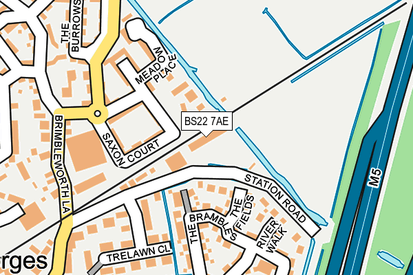
BS22 7AE is located in the Wick St Lawrence & St Georges electoral ward, within the unitary authority of North Somerset and the English Parliamentary constituency of Weston-Super-Mare. The Sub Integrated Care Board (ICB) Location is NHS Bristol, North Somerset and South Gloucestershire ICB - 15C and the police force is Avon and Somerset. This postcode has been in use since August 2010.


GetTheData
Source: OS OpenMap – Local (Ordnance Survey)
Source: OS VectorMap District (Ordnance Survey)
Licence: Open Government Licence (requires attribution)
| Easting | 337743 |
| Northing | 163071 |
| Latitude | 51.363274 |
| Longitude | -2.895611 |
GetTheData
Source: Open Postcode Geo
Licence: Open Government Licence
| Country | England |
| Postcode District | BS22 |
| ➜ BS22 open data dashboard ➜ See where BS22 is on a map ➜ Where is Weston-Super-Mare? | |
GetTheData
Source: Land Registry Price Paid Data
Licence: Open Government Licence
Elevation or altitude of BS22 7AE as distance above sea level:
| Metres | Feet | |
|---|---|---|
| Elevation | 10m | 33ft |
Elevation is measured from the approximate centre of the postcode, to the nearest point on an OS contour line from OS Terrain 50, which has contour spacing of ten vertical metres.
➜ How high above sea level am I? Find the elevation of your current position using your device's GPS.
GetTheData
Source: Open Postcode Elevation
Licence: Open Government Licence
| Ward | Wick St Lawrence & St Georges |
| Constituency | Weston-super-mare |
GetTheData
Source: ONS Postcode Database
Licence: Open Government Licence
| December 2023 | Drugs | On or near Station Road | 296m |
| June 2023 | Criminal damage and arson | On or near The Brambles | 145m |
| April 2023 | Violence and sexual offences | On or near Station Road | 296m |
| ➜ Get more crime data in our Crime section | |||
GetTheData
Source: data.police.uk
Licence: Open Government Licence
| St Georges Post Office | St George's | 259m |
| St Georges Post Office (Station Road) | St George's | 270m |
| Jubilee Way (Pastures Avenue) | St George's | 296m |
| Jubilee Way (Pastures Avenue) | St George's | 316m |
| Vale Crescent | St George's | 372m |
| Worle Station | 1.1km |
| Weston Milton Station | 3.7km |
| Yatton Station | 5.6km |
GetTheData
Source: NaPTAN
Licence: Open Government Licence
GetTheData
Source: ONS Postcode Database
Licence: Open Government Licence


➜ Get more ratings from the Food Standards Agency
GetTheData
Source: Food Standards Agency
Licence: FSA terms & conditions
| Last Collection | |||
|---|---|---|---|
| Location | Mon-Fri | Sat | Distance |
| St Georges (Old Post Office) | 17:00 | 08:45 | 313m |
| Doubleton House | 16:30 | 08:00 | 698m |
| Queensway Post Office | 17:30 | 12:15 | 1,123m |
GetTheData
Source: Dracos
Licence: Creative Commons Attribution-ShareAlike
| Facility | Distance |
|---|---|
| Priory Community School Queensway, Weston-super-mare Sports Hall, Artificial Grass Pitch, Grass Pitches, Health and Fitness Gym | 1km |
| Castle Batch Primary School Academy Rawlins Avenue, Weston-super-mare Grass Pitches | 1.6km |
| Weston-super-range (Closed) Wolvershill Road, Banwell Golf | 1.8km |
GetTheData
Source: Active Places
Licence: Open Government Licence
| School | Phase of Education | Distance |
|---|---|---|
| St Georges Church School Pastures Avenue, St Georges, Weston-Super-Mare, BS22 7SA | Primary | 330m |
| Priory Community School Queensway, Weston-Super-Mare, BS22 6BP | Secondary | 1km |
| Becket Primary School Tavistock Road, Worle, Weston-super-Mare, BS22 6DH | Primary | 1.4km |
GetTheData
Source: Edubase
Licence: Open Government Licence
| Risk of BS22 7AE flooding from rivers and sea | Low |
| ➜ BS22 7AE flood map | |
GetTheData
Source: Open Flood Risk by Postcode
Licence: Open Government Licence
The below table lists the International Territorial Level (ITL) codes (formerly Nomenclature of Territorial Units for Statistics (NUTS) codes) and Local Administrative Units (LAU) codes for BS22 7AE:
| ITL 1 Code | Name |
|---|---|
| TLK | South West (England) |
| ITL 2 Code | Name |
| TLK1 | Gloucestershire, Wiltshire and Bath/Bristol area |
| ITL 3 Code | Name |
| TLK12 | Bath and North East Somerset, North Somerset and South Gloucestershire |
| LAU 1 Code | Name |
| E06000024 | North Somerset |
GetTheData
Source: ONS Postcode Directory
Licence: Open Government Licence
The below table lists the Census Output Area (OA), Lower Layer Super Output Area (LSOA), and Middle Layer Super Output Area (MSOA) for BS22 7AE:
| Code | Name | |
|---|---|---|
| OA | E00166234 | |
| LSOA | E01032666 | North Somerset 026B |
| MSOA | E02006845 | North Somerset 026 |
GetTheData
Source: ONS Postcode Directory
Licence: Open Government Licence
| BS22 7RQ | Saxon Court | 62m |
| BS22 7SG | The Fields | 89m |
| BS22 7RG | Saxon Court | 132m |
| BS22 7SX | The Brambles | 135m |
| BS22 7SN | River Walk | 146m |
| BS22 7RT | Meadow Place | 152m |
| BS22 7XN | Station Road | 176m |
| BS22 7RS | Bourton Lane | 177m |
| BS22 7XW | Trelawn Close | 195m |
| BS22 7SF | Willow Close | 230m |
GetTheData
Source: Open Postcode Geo; Land Registry Price Paid Data
Licence: Open Government Licence