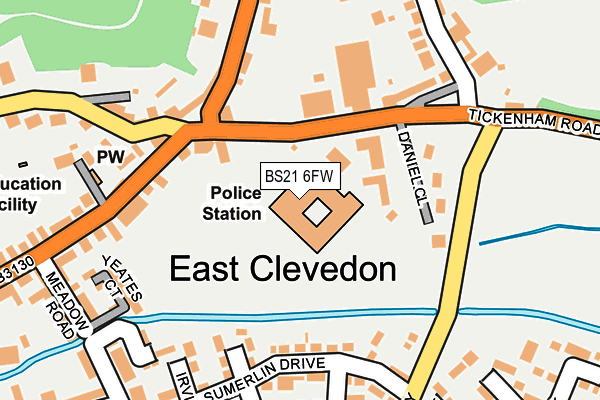
BS21 6FW is located in the Clevedon East electoral ward, within the unitary authority of North Somerset and the English Parliamentary constituency of North Somerset. The Sub Integrated Care Board (ICB) Location is NHS Bristol, North Somerset and South Gloucestershire ICB - 15C and the police force is Avon and Somerset. This postcode has been in use since July 2010.


GetTheData
Source: OS OpenMap – Local (Ordnance Survey)
Source: OS VectorMap District (Ordnance Survey)
Licence: Open Government Licence (requires attribution)
| Easting | 341642 |
| Northing | 171412 |
| Latitude | 51.438683 |
| Longitude | -2.840985 |
GetTheData
Source: Open Postcode Geo
Licence: Open Government Licence
| Country | England |
| Postcode District | BS21 |
| ➜ BS21 open data dashboard ➜ See where BS21 is on a map ➜ Where is Clevedon? | |
GetTheData
Source: Land Registry Price Paid Data
Licence: Open Government Licence
Elevation or altitude of BS21 6FW as distance above sea level:
| Metres | Feet | |
|---|---|---|
| Elevation | 10m | 33ft |
Elevation is measured from the approximate centre of the postcode, to the nearest point on an OS contour line from OS Terrain 50, which has contour spacing of ten vertical metres.
➜ How high above sea level am I? Find the elevation of your current position using your device's GPS.
GetTheData
Source: Open Postcode Elevation
Licence: Open Government Licence
| Ward | Clevedon East |
| Constituency | North Somerset |
GetTheData
Source: ONS Postcode Database
Licence: Open Government Licence
| January 2024 | Violence and sexual offences | On or near Maynard Close | 393m |
| January 2024 | Violence and sexual offences | On or near Maynard Close | 393m |
| December 2023 | Violence and sexual offences | On or near Maynard Close | 393m |
| ➜ Get more crime data in our Crime section | |||
GetTheData
Source: data.police.uk
Licence: Open Government Licence
| Castlewood (Tickenham Road) | East Clevedon | 80m |
| Castlewood (Tickenham Road) | East Clevedon | 81m |
| Sumerlin Drive (Northern Way) | East Clevedon | 213m |
| Brookfield Walk (Northern Way) | East Clevedon | 287m |
| Clevedon Health Centre (Old Street) | East Clevedon | 378m |
GetTheData
Source: NaPTAN
Licence: Open Government Licence
GetTheData
Source: ONS Postcode Database
Licence: Open Government Licence


➜ Get more ratings from the Food Standards Agency
GetTheData
Source: Food Standards Agency
Licence: FSA terms & conditions
| Last Collection | |||
|---|---|---|---|
| Location | Mon-Fri | Sat | Distance |
| East Clevedon | 17:15 | 12:30 | 155m |
| All Saints Lane | 17:15 | 12:30 | 368m |
| Old Street | 17:15 | 12:30 | 590m |
GetTheData
Source: Dracos
Licence: Creative Commons Attribution-ShareAlike
| Facility | Distance |
|---|---|
| St Nicholas Chantry Primary School Highdale Avenue, Clevedon Grass Pitches | 316m |
| Clevedon Bowling Club Chapel Hill, Clevedon Indoor Bowls | 813m |
| Ymca (Clevedon) Marson Road, Clevedon Sports Hall | 904m |
GetTheData
Source: Active Places
Licence: Open Government Licence
| School | Phase of Education | Distance |
|---|---|---|
| St Nicholas Chantry Church of England Primary School Highdale Avenue, Clevedon, BS21 7LT | Primary | 367m |
| All Saints Church of England Primary School All Saints Lane, Clevedon, BS21 6AU | Primary | 386m |
| Seven Hills 80b Kenn Road, Clevedon, North Somerset, BS21 6EX | Not applicable | 890m |
GetTheData
Source: Edubase
Licence: Open Government Licence
| Risk of BS21 6FW flooding from rivers and sea | Low |
| ➜ BS21 6FW flood map | |
GetTheData
Source: Open Flood Risk by Postcode
Licence: Open Government Licence
The below table lists the International Territorial Level (ITL) codes (formerly Nomenclature of Territorial Units for Statistics (NUTS) codes) and Local Administrative Units (LAU) codes for BS21 6FW:
| ITL 1 Code | Name |
|---|---|
| TLK | South West (England) |
| ITL 2 Code | Name |
| TLK1 | Gloucestershire, Wiltshire and Bath/Bristol area |
| ITL 3 Code | Name |
| TLK12 | Bath and North East Somerset, North Somerset and South Gloucestershire |
| LAU 1 Code | Name |
| E06000024 | North Somerset |
GetTheData
Source: ONS Postcode Directory
Licence: Open Government Licence
The below table lists the Census Output Area (OA), Lower Layer Super Output Area (LSOA), and Middle Layer Super Output Area (MSOA) for BS21 6FW:
| Code | Name | |
|---|---|---|
| OA | E00074522 | |
| LSOA | E01014752 | North Somerset 005A |
| MSOA | E02003069 | North Somerset 005 |
GetTheData
Source: ONS Postcode Directory
Licence: Open Government Licence
| BS21 6BQ | East Clevedon Triangle | 115m |
| BS21 6BB | Daniel Close | 142m |
| BS21 6AA | Tickenham Road | 154m |
| BS21 6YT | Broadlands | 176m |
| BS21 6YW | Sumerlin Drive | 176m |
| BS21 6BH | Old Street | 182m |
| BS21 6HU | Yeates Court | 199m |
| BS21 6YP | Hollyman Walk | 208m |
| BS21 6HA | Powells Acres | 216m |
| BS21 6AE | Walton Road | 222m |
GetTheData
Source: Open Postcode Geo; Land Registry Price Paid Data
Licence: Open Government Licence