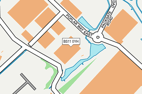
BS11 0YH lies on Poplar Way East in Bristol. BS11 0YH is located in the Avonmouth and Lawrence Weston electoral ward, within the unitary authority of Bristol, City of and the English Parliamentary constituency of Bristol North West. The Sub Integrated Care Board (ICB) Location is NHS Bristol, North Somerset and South Gloucestershire ICB - 15C and the police force is Avon and Somerset. This postcode has been in use since February 2003.


GetTheData
Source: OS OpenMap – Local (Ordnance Survey)
Source: OS VectorMap District (Ordnance Survey)
Licence: Open Government Licence (requires attribution)
| Easting | 353647 |
| Northing | 179843 |
| Latitude | 51.515597 |
| Longitude | -2.669393 |
GetTheData
Source: Open Postcode Geo
Licence: Open Government Licence
| Street | Poplar Way East |
| Town/City | Bristol |
| Country | England |
| Postcode District | BS11 |
| ➜ BS11 open data dashboard ➜ See where BS11 is on a map | |
GetTheData
Source: Land Registry Price Paid Data
Licence: Open Government Licence
Elevation or altitude of BS11 0YH as distance above sea level:
| Metres | Feet | |
|---|---|---|
| Elevation | 10m | 33ft |
Elevation is measured from the approximate centre of the postcode, to the nearest point on an OS contour line from OS Terrain 50, which has contour spacing of ten vertical metres.
➜ How high above sea level am I? Find the elevation of your current position using your device's GPS.
GetTheData
Source: Open Postcode Elevation
Licence: Open Government Licence
| Ward | Avonmouth And Lawrence Weston |
| Constituency | Bristol North West |
GetTheData
Source: ONS Postcode Database
Licence: Open Government Licence
| June 2022 | Public order | On or near Poplar Way East | 276m |
| May 2022 | Other theft | On or near Poplar Way East | 276m |
| March 2022 | Other theft | On or near Poplar Way East | 276m |
| ➜ Poplar Way East crime map and outcomes | |||
GetTheData
Source: data.police.uk
Licence: Open Government Licence
| Moorhouse Park (Moorhouse Lane) | Hallen | 1,104m |
| Hi-ways Park (Moorhouse Lane) | Hallen | 1,201m |
| The William Iv (Berwick Lane) | Hallen | 1,448m |
| The William Iv | Hallen | 1,466m |
| Lawrence Weston Road (Long Cross) | Lawrence Weston | 1,526m |
| St Andrews Road Station | 1.9km |
| Avonmouth Station | 2.7km |
| Shirehampton Station | 3.5km |
GetTheData
Source: NaPTAN
Licence: Open Government Licence
Estimated total energy consumption in BS11 0YH by fuel type, 2015.
| Consumption (kWh) | 203,994 |
|---|---|
| Meter count | 6 |
| Mean (kWh/meter) | 33,999 |
| Median (kWh/meter) | 37,020 |
GetTheData
Source: Postcode level gas estimates: 2015 (experimental)
Source: Postcode level electricity estimates: 2015 (experimental)
Licence: Open Government Licence
GetTheData
Source: ONS Postcode Database
Licence: Open Government Licence

➜ Get more ratings from the Food Standards Agency
GetTheData
Source: Food Standards Agency
Licence: FSA terms & conditions
| Last Collection | |||
|---|---|---|---|
| Location | Mon-Fri | Sat | Distance |
| Hallen | 17:00 | 11:00 | 1,430m |
| Fourthway | 18:30 | 07:15 | 1,512m |
| Capel Road | 18:00 | 12:15 | 1,821m |
GetTheData
Source: Dracos
Licence: Creative Commons Attribution-ShareAlike
| Facility | Distance |
|---|---|
| Hallen Centre Moorhouse Lane, Hallen, Bristol Grass Pitches, Outdoor Tennis Courts, Artificial Grass Pitch | 1.1km |
| Old Elizabethans Severn Road, Hallen Grass Pitches | 1.3km |
| Lawrence Rovers Football Club Lawrence Weston Road, Bristol Grass Pitches | 1.3km |
GetTheData
Source: Active Places
Licence: Open Government Licence
| School | Phase of Education | Distance |
|---|---|---|
| St Bede's Catholic College Long Cross, Lawrence Weston, Bristol, BS11 0SU | Secondary | 1.5km |
| Oasis Academy Bank Leaze Corbet Close, Lawrence Weston, Bristol, BS11 0SN | Primary | 1.6km |
| Our Lady of the Rosary Catholic Primary School, Bristol Tide Grove, Lawrence Weston, Bristol, BS11 0PA | Primary | 1.9km |
GetTheData
Source: Edubase
Licence: Open Government Licence
| Risk of BS11 0YH flooding from rivers and sea | Low |
| ➜ BS11 0YH flood map | |
GetTheData
Source: Open Flood Risk by Postcode
Licence: Open Government Licence
The below table lists the International Territorial Level (ITL) codes (formerly Nomenclature of Territorial Units for Statistics (NUTS) codes) and Local Administrative Units (LAU) codes for BS11 0YH:
| ITL 1 Code | Name |
|---|---|
| TLK | South West (England) |
| ITL 2 Code | Name |
| TLK1 | Gloucestershire, Wiltshire and Bath/Bristol area |
| ITL 3 Code | Name |
| TLK11 | Bristol, City of |
| LAU 1 Code | Name |
| E06000023 | Bristol, City of |
GetTheData
Source: ONS Postcode Directory
Licence: Open Government Licence
The below table lists the Census Output Area (OA), Lower Layer Super Output Area (LSOA), and Middle Layer Super Output Area (MSOA) for BS11 0YH:
| Code | Name | |
|---|---|---|
| OA | E00073219 | |
| LSOA | E01014498 | Bristol 003B |
| MSOA | E02003014 | Bristol 003 |
GetTheData
Source: ONS Postcode Directory
Licence: Open Government Licence
| BS11 0RS | Moorend Farm Avenue | 454m |
| BS11 8AZ | Kings Weston Lane | 1049m |
| BS10 7RT | Moorhouse Lane | 1299m |
| BS11 8AP | Burcott Road | 1312m |
| BS10 7SH | Berwick Court | 1388m |
| BS11 0ST | Lawrence Weston Road | 1392m |
| BS10 7RZ | Severn Road | 1401m |
| BS11 0SS | Atwood Drive | 1424m |
| BS11 0SR | Atwood Drive | 1426m |
| BS10 7RP | Hallen Road | 1443m |
GetTheData
Source: Open Postcode Geo; Land Registry Price Paid Data
Licence: Open Government Licence