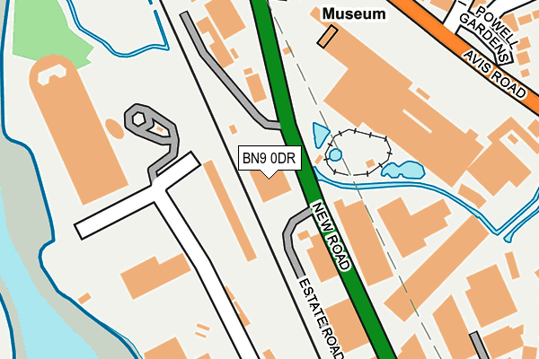
BN9 0DR is located in the Newhaven North electoral ward, within the local authority district of Lewes and the English Parliamentary constituency of Lewes. The Sub Integrated Care Board (ICB) Location is NHS Sussex ICB - 97R and the police force is Sussex. This postcode has been in use since June 2001.


GetTheData
Source: OS OpenMap – Local (Ordnance Survey)
Source: OS VectorMap District (Ordnance Survey)
Licence: Open Government Licence (requires attribution)
| Easting | 544710 |
| Northing | 102195 |
| Latitude | 50.801252 |
| Longitude | 0.052189 |
GetTheData
Source: Open Postcode Geo
Licence: Open Government Licence
| Country | England |
| Postcode District | BN9 |
| ➜ BN9 open data dashboard ➜ See where BN9 is on a map ➜ Where is Newhaven? | |
GetTheData
Source: Land Registry Price Paid Data
Licence: Open Government Licence
Elevation or altitude of BN9 0DR as distance above sea level:
| Metres | Feet | |
|---|---|---|
| Elevation | 10m | 33ft |
Elevation is measured from the approximate centre of the postcode, to the nearest point on an OS contour line from OS Terrain 50, which has contour spacing of ten vertical metres.
➜ How high above sea level am I? Find the elevation of your current position using your device's GPS.
GetTheData
Source: Open Postcode Elevation
Licence: Open Government Licence
| Ward | Newhaven North |
| Constituency | Lewes |
GetTheData
Source: ONS Postcode Database
Licence: Open Government Licence
| June 2022 | Violence and sexual offences | On or near Powell Gardens | 345m |
| June 2022 | Anti-social behaviour | On or near Powell Gardens | 345m |
| June 2022 | Criminal damage and arson | On or near Avis Way | 408m |
| ➜ Get more crime data in our Crime section | |||
GetTheData
Source: data.police.uk
Licence: Open Government Licence
| Paradise Park (Avis Road) | Denton | 242m |
| Paradise Park (Avis Road) | Denton | 260m |
| Powell Gardens (Iveagh Crescent) | Denton | 284m |
| Guinness Court (Iveagh Crescent) | Newhaven | 355m |
| Boc Edwards (Avis Way) | Newhaven | 362m |
| Newhaven Town Station | 0.7km |
| Newhaven Harbour Station | 1.3km |
| Bishopstone Station | 3.2km |
GetTheData
Source: NaPTAN
Licence: Open Government Licence
GetTheData
Source: ONS Postcode Database
Licence: Open Government Licence


➜ Get more ratings from the Food Standards Agency
GetTheData
Source: Food Standards Agency
Licence: FSA terms & conditions
| Last Collection | |||
|---|---|---|---|
| Location | Mon-Fri | Sat | Distance |
| Newhaven Post Office | 17:30 | 12:30 | 825m |
| South Way | 17:15 | 12:00 | 843m |
| Royal Mail High Street | 18:15 | 12:30 | 890m |
GetTheData
Source: Dracos
Licence: Creative Commons Attribution-ShareAlike
| Facility | Distance |
|---|---|
| Denton Cricket Club Avis Road, Denton, Newhaven Grass Pitches | 456m |
| Denton Island Indoor Bowls Club Denton Island, Newhaven Indoor Bowls | 475m |
| Seahaven Swim & Fitness Centre Chapel Street, Newhaven Swimming Pool, Health and Fitness Gym | 829m |
GetTheData
Source: Active Places
Licence: Open Government Licence
| School | Phase of Education | Distance |
|---|---|---|
| Denton Community Primary School and Nursery Acacia Road, Denton, Newhaven, BN9 0QJ | Primary | 519m |
| Harbour Primary and Nursery School Church Hill, Newhaven, BN9 9LX | Primary | 1.2km |
| Breakwater Academy Valley Road, Newhaven, BN9 9UT | Primary | 1.4km |
GetTheData
Source: Edubase
Licence: Open Government Licence
| Risk of BN9 0DR flooding from rivers and sea | Medium |
| ➜ BN9 0DR flood map | |
GetTheData
Source: Open Flood Risk by Postcode
Licence: Open Government Licence
The below table lists the International Territorial Level (ITL) codes (formerly Nomenclature of Territorial Units for Statistics (NUTS) codes) and Local Administrative Units (LAU) codes for BN9 0DR:
| ITL 1 Code | Name |
|---|---|
| TLJ | South East (England) |
| ITL 2 Code | Name |
| TLJ2 | Surrey, East and West Sussex |
| ITL 3 Code | Name |
| TLJ22 | East Sussex CC |
| LAU 1 Code | Name |
| E07000063 | Lewes |
GetTheData
Source: ONS Postcode Directory
Licence: Open Government Licence
The below table lists the Census Output Area (OA), Lower Layer Super Output Area (LSOA), and Middle Layer Super Output Area (MSOA) for BN9 0DR:
| Code | Name | |
|---|---|---|
| OA | E00106899 | |
| LSOA | E01021047 | Lewes 008C |
| MSOA | E02004386 | Lewes 008 |
GetTheData
Source: ONS Postcode Directory
Licence: Open Government Licence
| BN9 0HE | New Road | 107m |
| BN9 0DH | Avis Way | 264m |
| BN9 0PR | Avis Road | 266m |
| BN9 0PQ | Cottage Close | 267m |
| BN9 0PH | St Martins Crescent | 295m |
| BN9 0DQ | Euro Business Park | 297m |
| BN9 0PP | Avis Road | 313m |
| BN9 0PG | Iford Close | 347m |
| BN9 0DP | Avis Way | 353m |
| BN9 0HG | Westview Terrace | 357m |
GetTheData
Source: Open Postcode Geo; Land Registry Price Paid Data
Licence: Open Government Licence