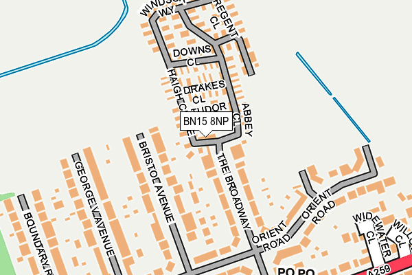
BN15 8NP is located in the Widewater electoral ward, within the local authority district of Adur and the English Parliamentary constituency of East Worthing and Shoreham. The Sub Integrated Care Board (ICB) Location is NHS Sussex ICB - 70F and the police force is Sussex. This postcode has been in use since July 1983.


GetTheData
Source: OS OpenMap – Local (Ordnance Survey)
Source: OS VectorMap District (Ordnance Survey)
Licence: Open Government Licence (requires attribution)
| Easting | 519871 |
| Northing | 104508 |
| Latitude | 50.827709 |
| Longitude | -0.299359 |
GetTheData
Source: Open Postcode Geo
Licence: Open Government Licence
| Country | England |
| Postcode District | BN15 |
| ➜ BN15 open data dashboard ➜ See where BN15 is on a map ➜ Where is Lancing? | |
GetTheData
Source: Land Registry Price Paid Data
Licence: Open Government Licence
Elevation or altitude of BN15 8NP as distance above sea level:
| Metres | Feet | |
|---|---|---|
| Elevation | 10m | 33ft |
Elevation is measured from the approximate centre of the postcode, to the nearest point on an OS contour line from OS Terrain 50, which has contour spacing of ten vertical metres.
➜ How high above sea level am I? Find the elevation of your current position using your device's GPS.
GetTheData
Source: Open Postcode Elevation
Licence: Open Government Licence
| Ward | Widewater |
| Constituency | East Worthing And Shoreham |
GetTheData
Source: ONS Postcode Database
Licence: Open Government Licence
| June 2022 | Violence and sexual offences | On or near George V Avenue | 200m |
| June 2022 | Anti-social behaviour | On or near Parking Area | 436m |
| June 2022 | Other theft | On or near Wenceling Cottages | 448m |
| ➜ Get more crime data in our Crime section | |||
GetTheData
Source: data.police.uk
Licence: Open Government Licence
| Broadway Park (The Broadway) | South Lancing | 18m |
| Orient Road (The Broadway) | South Lancing | 193m |
| Orient Road (The Broadway) | South Lancing | 198m |
| The Broadway (Brighton Road) | South Lancing | 267m |
| The Broadway (Brighton Road A259) | South Lancing | 276m |
| Lancing Station | 1.7km |
| Shoreham-by-Sea (Sussex) Station | 2.1km |
| East Worthing Station | 4km |
GetTheData
Source: NaPTAN
Licence: Open Government Licence
GetTheData
Source: ONS Postcode Database
Licence: Open Government Licence


➜ Get more ratings from the Food Standards Agency
GetTheData
Source: Food Standards Agency
Licence: FSA terms & conditions
| Last Collection | |||
|---|---|---|---|
| Location | Mon-Fri | Sat | Distance |
| Shoreham Airport | 17:00 | 12:00 | 823m |
| West Beach Post Office | 17:30 | 12:15 | 879m |
| Beach Green | 17:30 | 12:15 | 1,302m |
GetTheData
Source: Dracos
Licence: Creative Commons Attribution-ShareAlike
| Facility | Distance |
|---|---|
| East Lancing Recreation Ground Orient Road, Lancing Grass Pitches | 157m |
| American Express Elite Football Performance Centre Mash Barn Lane, Lancing Artificial Grass Pitch, Grass Pitches | 931m |
| Seaside Primary School Freshbrook Road, Lancing Grass Pitches, Sports Hall | 986m |
GetTheData
Source: Active Places
Licence: Open Government Licence
| School | Phase of Education | Distance |
|---|---|---|
| Seaside Primary School Freshbrook Road, Lancing, BN15 8DL | Primary | 957m |
| Springboard Education 55 South Street, Lancing, West Sussex, Lancing, BN15 8AN | Not applicable | 1.7km |
| Swiss Gardens Primary School Swiss Gardens, Shoreham-by-Sea, BN43 5WH | Primary | 1.7km |
GetTheData
Source: Edubase
Licence: Open Government Licence
| Risk of BN15 8NP flooding from rivers and sea | Low |
| ➜ BN15 8NP flood map | |
GetTheData
Source: Open Flood Risk by Postcode
Licence: Open Government Licence
The below table lists the International Territorial Level (ITL) codes (formerly Nomenclature of Territorial Units for Statistics (NUTS) codes) and Local Administrative Units (LAU) codes for BN15 8NP:
| ITL 1 Code | Name |
|---|---|
| TLJ | South East (England) |
| ITL 2 Code | Name |
| TLJ2 | Surrey, East and West Sussex |
| ITL 3 Code | Name |
| TLJ27 | West Sussex (South West) |
| LAU 1 Code | Name |
| E07000223 | Adur |
GetTheData
Source: ONS Postcode Directory
Licence: Open Government Licence
The below table lists the Census Output Area (OA), Lower Layer Super Output Area (LSOA), and Middle Layer Super Output Area (MSOA) for BN15 8NP:
| Code | Name | |
|---|---|---|
| OA | E00159976 | |
| LSOA | E01031378 | Adur 007D |
| MSOA | E02006540 | Adur 007 |
GetTheData
Source: ONS Postcode Directory
Licence: Open Government Licence
| BN15 8NN | The Broadway | 93m |
| BN15 8NY | The Broadway | 103m |
| BN15 8NL | Bristol Avenue | 109m |
| BN15 8NJ | Bristol Avenue | 139m |
| BN15 8NQ | George V Avenue | 171m |
| BN15 8JY | Orient Road | 200m |
| BN15 8LU | West Way | 204m |
| BN15 8LT | The Broadway | 217m |
| BN15 8NG | George V Avenue | 226m |
| BN15 8DU | Sussex Road | 226m |
GetTheData
Source: Open Postcode Geo; Land Registry Price Paid Data
Licence: Open Government Licence