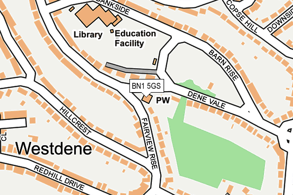
BN1 5GS is located in the Westdene & Hove Park electoral ward, within the unitary authority of Brighton and Hove and the English Parliamentary constituency of Brighton, Pavilion. The Sub Integrated Care Board (ICB) Location is NHS Sussex ICB - 09D and the police force is Sussex. This postcode has been in use since May 2013.


GetTheData
Source: OS OpenMap – Local (Ordnance Survey)
Source: OS VectorMap District (Ordnance Survey)
Licence: Open Government Licence (requires attribution)
| Easting | 529521 |
| Northing | 108135 |
| Latitude | 50.858231 |
| Longitude | -0.161134 |
GetTheData
Source: Open Postcode Geo
Licence: Open Government Licence
| Country | England |
| Postcode District | BN1 |
| ➜ BN1 open data dashboard ➜ See where BN1 is on a map ➜ Where is Brighton? | |
GetTheData
Source: Land Registry Price Paid Data
Licence: Open Government Licence
Elevation or altitude of BN1 5GS as distance above sea level:
| Metres | Feet | |
|---|---|---|
| Elevation | 70m | 230ft |
Elevation is measured from the approximate centre of the postcode, to the nearest point on an OS contour line from OS Terrain 50, which has contour spacing of ten vertical metres.
➜ How high above sea level am I? Find the elevation of your current position using your device's GPS.
GetTheData
Source: Open Postcode Elevation
Licence: Open Government Licence
| Ward | Westdene & Hove Park |
| Constituency | Brighton, Pavilion |
GetTheData
Source: ONS Postcode Database
Licence: Open Government Licence
| June 2022 | Public order | On or near Bankside | 197m |
| June 2022 | Violence and sexual offences | On or near Redhill Close | 286m |
| June 2022 | Burglary | On or near Hillbrow Road | 294m |
| ➜ Get more crime data in our Crime section | |||
GetTheData
Source: data.police.uk
Licence: Open Government Licence
| Top Of Copse Hill (Copse Hill) | Westdene | 249m |
| Top Of Copse Hill (Copse Hill) | Westdene | 269m |
| Bramble Rise | Westdene | 307m |
| Bramble Rise | Westdene | 322m |
| The Deneway West (Eldred Avenue) | Westdene | 332m |
| Preston Park Station | 1.4km |
| Hove Station | 2.6km |
| Aldrington Station | 2.9km |
GetTheData
Source: NaPTAN
Licence: Open Government Licence
GetTheData
Source: ONS Postcode Database
Licence: Open Government Licence


➜ Get more ratings from the Food Standards Agency
GetTheData
Source: Food Standards Agency
Licence: FSA terms & conditions
| Last Collection | |||
|---|---|---|---|
| Location | Mon-Fri | Sat | Distance |
| Fernwood Rise | 17:00 | 10:45 | 163m |
| Eldred Avenue Post Office | 17:00 | 12:15 | 328m |
| Tongdean Lane | 16:45 | 10:30 | 473m |
GetTheData
Source: Dracos
Licence: Creative Commons Attribution-ShareAlike
| Facility | Distance |
|---|---|
| Westdene Primary School Bankside, Brighton Grass Pitches | 210m |
| Gatton Park Glen Rise, Brighton Grass Pitches | 497m |
| Withdean Sports Complex Tongdean Lane, Withdean, Brighton Athletics, Health and Fitness Gym, Indoor Tennis Centre, Grass Pitches, Studio, Squash Courts, Outdoor Tennis Courts | 684m |
GetTheData
Source: Active Places
Licence: Open Government Licence
| School | Phase of Education | Distance |
|---|---|---|
| Westdene Primary School Bankside, Westdene, Brighton, BN1 5GN | Primary | 211m |
| Downs View Life Skills College 7 Old London Road, Patcham, Brighton, BN1 8XR | Not applicable | 808m |
| Patcham Infant School Highview Avenue South, Brighton, BN1 8WW | Primary | 1km |
GetTheData
Source: Edubase
Licence: Open Government Licence
The below table lists the International Territorial Level (ITL) codes (formerly Nomenclature of Territorial Units for Statistics (NUTS) codes) and Local Administrative Units (LAU) codes for BN1 5GS:
| ITL 1 Code | Name |
|---|---|
| TLJ | South East (England) |
| ITL 2 Code | Name |
| TLJ2 | Surrey, East and West Sussex |
| ITL 3 Code | Name |
| TLJ21 | Brighton and Hove |
| LAU 1 Code | Name |
| E06000043 | Brighton and Hove |
GetTheData
Source: ONS Postcode Directory
Licence: Open Government Licence
The below table lists the Census Output Area (OA), Lower Layer Super Output Area (LSOA), and Middle Layer Super Output Area (MSOA) for BN1 5GS:
| Code | Name | |
|---|---|---|
| OA | E00085865 | |
| LSOA | E01016998 | Brighton and Hove 003C |
| MSOA | E02003493 | Brighton and Hove 003 |
GetTheData
Source: ONS Postcode Directory
Licence: Open Government Licence
| BN1 5GR | Mill Rise | 45m |
| BN1 5GQ | Mill Rise | 46m |
| BN1 5GL | Fairview Rise | 69m |
| BN1 5FR | Hillcrest | 104m |
| BN1 5GJ | Mill Rise | 143m |
| BN1 5FN | Hillcrest | 145m |
| BN1 5FP | Hillcrest | 159m |
| BN1 5ED | Dene Vale | 165m |
| BN1 5GH | Mill Rise | 186m |
| BN1 5EE | Barn Rise | 197m |
GetTheData
Source: Open Postcode Geo; Land Registry Price Paid Data
Licence: Open Government Licence