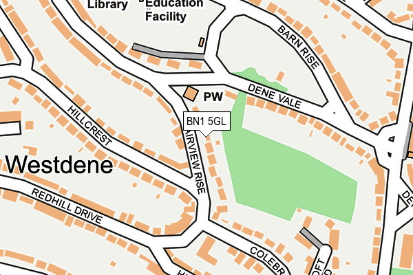
BN1 5GL lies on Fairview Rise in Brighton. BN1 5GL is located in the Westdene & Hove Park electoral ward, within the unitary authority of Brighton and Hove and the English Parliamentary constituency of Brighton, Pavilion. The Sub Integrated Care Board (ICB) Location is NHS Sussex ICB - 09D and the police force is Sussex. This postcode has been in use since January 1980.


GetTheData
Source: OS OpenMap – Local (Ordnance Survey)
Source: OS VectorMap District (Ordnance Survey)
Licence: Open Government Licence (requires attribution)
| Easting | 529545 |
| Northing | 108070 |
| Latitude | 50.857642 |
| Longitude | -0.160816 |
GetTheData
Source: Open Postcode Geo
Licence: Open Government Licence
| Street | Fairview Rise |
| Town/City | Brighton |
| Country | England |
| Postcode District | BN1 |
➜ See where BN1 is on a map ➜ Where is Brighton? | |
GetTheData
Source: Land Registry Price Paid Data
Licence: Open Government Licence
Elevation or altitude of BN1 5GL as distance above sea level:
| Metres | Feet | |
|---|---|---|
| Elevation | 80m | 262ft |
Elevation is measured from the approximate centre of the postcode, to the nearest point on an OS contour line from OS Terrain 50, which has contour spacing of ten vertical metres.
➜ How high above sea level am I? Find the elevation of your current position using your device's GPS.
GetTheData
Source: Open Postcode Elevation
Licence: Open Government Licence
| Ward | Westdene & Hove Park |
| Constituency | Brighton, Pavilion |
GetTheData
Source: ONS Postcode Database
Licence: Open Government Licence
18, FAIRVIEW RISE, BRIGHTON, BN1 5GL 1998 10 AUG £112,500 |
GetTheData
Source: HM Land Registry Price Paid Data
Licence: Contains HM Land Registry data © Crown copyright and database right 2025. This data is licensed under the Open Government Licence v3.0.
| The Deneway West (Eldred Avenue) | Westdene | 284m |
| Top Of Copse Hill (Copse Hill) | Westdene | 288m |
| Valley Close (Valley Drive) | Westdene | 307m |
| Top Of Copse Hill (Copse Hill) | Westdene | 312m |
| Copse Hill (Eldred Avenue) | Westdene | 326m |
| Preston Park Station | 1.4km |
| Hove Station | 2.6km |
| Aldrington Station | 2.9km |
GetTheData
Source: NaPTAN
Licence: Open Government Licence
| Percentage of properties with Next Generation Access | 100.0% |
| Percentage of properties with Superfast Broadband | 100.0% |
| Percentage of properties with Ultrafast Broadband | 100.0% |
| Percentage of properties with Full Fibre Broadband | 0.0% |
Superfast Broadband is between 30Mbps and 300Mbps
Ultrafast Broadband is > 300Mbps
| Median download speed | 48.7Mbps |
| Average download speed | 71.1Mbps |
| Maximum download speed | 200.00Mbps |
| Median upload speed | 5.6Mbps |
| Average upload speed | 6.8Mbps |
| Maximum upload speed | 19.53Mbps |
| Percentage of properties unable to receive 2Mbps | 0.0% |
| Percentage of properties unable to receive 5Mbps | 0.0% |
| Percentage of properties unable to receive 10Mbps | 0.0% |
| Percentage of properties unable to receive 30Mbps | 0.0% |
GetTheData
Source: Ofcom
Licence: Ofcom Terms of Use (requires attribution)
Estimated total energy consumption in BN1 5GL by fuel type, 2015.
| Consumption (kWh) | 470,452 |
|---|---|
| Meter count | 26 |
| Mean (kWh/meter) | 18,094 |
| Median (kWh/meter) | 17,575 |
| Consumption (kWh) | 77,687 |
|---|---|
| Meter count | 22 |
| Mean (kWh/meter) | 3,531 |
| Median (kWh/meter) | 3,214 |
GetTheData
Source: Postcode level gas estimates: 2015 (experimental)
Source: Postcode level electricity estimates: 2015 (experimental)
Licence: Open Government Licence
GetTheData
Source: ONS Postcode Database
Licence: Open Government Licence


➜ Get more ratings from the Food Standards Agency
GetTheData
Source: Food Standards Agency
Licence: FSA terms & conditions
| Last Collection | |||
|---|---|---|---|
| Location | Mon-Fri | Sat | Distance |
| Fernwood Rise | 17:00 | 10:45 | 221m |
| Eldred Avenue Post Office | 17:00 | 12:15 | 292m |
| Tongdean Lane | 16:45 | 10:30 | 407m |
GetTheData
Source: Dracos
Licence: Creative Commons Attribution-ShareAlike
The below table lists the International Territorial Level (ITL) codes (formerly Nomenclature of Territorial Units for Statistics (NUTS) codes) and Local Administrative Units (LAU) codes for BN1 5GL:
| ITL 1 Code | Name |
|---|---|
| TLJ | South East (England) |
| ITL 2 Code | Name |
| TLJ2 | Surrey, East and West Sussex |
| ITL 3 Code | Name |
| TLJ21 | Brighton and Hove |
| LAU 1 Code | Name |
| E06000043 | Brighton and Hove |
GetTheData
Source: ONS Postcode Directory
Licence: Open Government Licence
The below table lists the Census Output Area (OA), Lower Layer Super Output Area (LSOA), and Middle Layer Super Output Area (MSOA) for BN1 5GL:
| Code | Name | |
|---|---|---|
| OA | E00085865 | |
| LSOA | E01016998 | Brighton and Hove 003C |
| MSOA | E02003493 | Brighton and Hove 003 |
GetTheData
Source: ONS Postcode Directory
Licence: Open Government Licence
| BN1 5FR | Hillcrest | 52m |
| BN1 5GR | Mill Rise | 110m |
| BN1 5GQ | Mill Rise | 115m |
| BN1 5ED | Dene Vale | 140m |
| BN1 5FP | Hillcrest | 159m |
| BN1 5FN | Hillcrest | 170m |
| BN1 5FL | Redhill Drive | 191m |
| BN1 5GJ | Mill Rise | 204m |
| BN1 5EE | Barn Rise | 208m |
| BN1 5JP | Hillbrow Road | 213m |
GetTheData
Source: Open Postcode Geo; Land Registry Price Paid Data
Licence: Open Government Licence