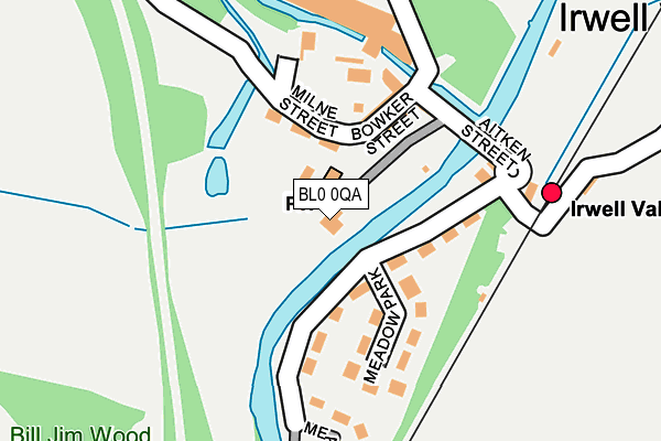
BL0 0QA is located in the Eden electoral ward, within the local authority district of Rossendale and the English Parliamentary constituency of Rossendale and Darwen. The Sub Integrated Care Board (ICB) Location is NHS Lancashire and South Cumbria ICB - 01A and the police force is Lancashire. This postcode has been in use since January 1980.


GetTheData
Source: OS OpenMap – Local (Ordnance Survey)
Source: OS VectorMap District (Ordnance Survey)
Licence: Open Government Licence (requires attribution)
| Easting | 379086 |
| Northing | 420149 |
| Latitude | 53.677383 |
| Longitude | -2.318081 |
GetTheData
Source: Open Postcode Geo
Licence: Open Government Licence
| Country | England |
| Postcode District | BL0 |
| ➜ BL0 open data dashboard ➜ See where BL0 is on a map ➜ Where is Irwell Vale? | |
GetTheData
Source: Land Registry Price Paid Data
Licence: Open Government Licence
Elevation or altitude of BL0 0QA as distance above sea level:
| Metres | Feet | |
|---|---|---|
| Elevation | 140m | 459ft |
Elevation is measured from the approximate centre of the postcode, to the nearest point on an OS contour line from OS Terrain 50, which has contour spacing of ten vertical metres.
➜ How high above sea level am I? Find the elevation of your current position using your device's GPS.
GetTheData
Source: Open Postcode Elevation
Licence: Open Government Licence
| Ward | Eden |
| Constituency | Rossendale And Darwen |
GetTheData
Source: ONS Postcode Database
Licence: Open Government Licence
| November 2023 | Anti-social behaviour | On or near Hardsough Lane | 412m |
| October 2023 | Public order | On or near Hardsough Lane | 412m |
| October 2023 | Anti-social behaviour | On or near Hardsough Lane | 412m |
| ➜ Get more crime data in our Crime section | |||
GetTheData
Source: data.police.uk
Licence: Open Government Licence
| Bowker Street (Irwell Vale Road) | Irwell Vale | 138m |
| Bowker Street (Aitken Street) | Irwell Vale | 138m |
| Vale Mill Court (Blackburn Road) | Edenfield | 762m |
| Vale Mill Court (Blackburn Road) | Edenfield | 816m |
| Moorlands View (Burnley Road) | Edenfield | 837m |
GetTheData
Source: NaPTAN
Licence: Open Government Licence
| Percentage of properties with Next Generation Access | 100.0% |
| Percentage of properties with Superfast Broadband | 0.0% |
| Percentage of properties with Ultrafast Broadband | 0.0% |
| Percentage of properties with Full Fibre Broadband | 0.0% |
Superfast Broadband is between 30Mbps and 300Mbps
Ultrafast Broadband is > 300Mbps
| Percentage of properties unable to receive 2Mbps | 0.0% |
| Percentage of properties unable to receive 5Mbps | 0.0% |
| Percentage of properties unable to receive 10Mbps | 0.0% |
| Percentage of properties unable to receive 30Mbps | 100.0% |
GetTheData
Source: Ofcom
Licence: Ofcom Terms of Use (requires attribution)
GetTheData
Source: ONS Postcode Database
Licence: Open Government Licence


➜ Get more ratings from the Food Standards Agency
GetTheData
Source: Food Standards Agency
Licence: FSA terms & conditions
| Last Collection | |||
|---|---|---|---|
| Location | Mon-Fri | Sat | Distance |
| Sidmouth Avenue | 17:30 | 12:15 | 2,384m |
| Railway Station | 16:45 | 12:30 | 3,033m |
| Haslingden Post Office | 17:15 | 12:00 | 3,068m |
GetTheData
Source: Dracos
Licence: Creative Commons Attribution-ShareAlike
| Facility | Distance |
|---|---|
| Ewood Bridge (Stand Athletic Fc) (Closed) Ashen Bottom, Rossendale Grass Pitches | 797m |
| Edenfield C Of E Primary School Market Street, Edenfield, Ramsbottom, Bury Grass Pitches | 877m |
| Rossendale Golf Club Ltd Ewood Lane, Haslingden, Rossendale Golf | 1km |
GetTheData
Source: Active Places
Licence: Open Government Licence
| School | Phase of Education | Distance |
|---|---|---|
| Edenfield Church of England Primary School Market Street, Edenfield, Ramsbottom, Bury, BL0 0HL | Primary | 877m |
| St Veronica's Roman Catholic Primary School, Helmshore Raven Avenue, Helmshore, BB4 4EZ | Primary | 1.3km |
| Haslingden High School and Sixth Form Broadway, Haslingden, Rossendale, BB4 4EY | Secondary | 1.3km |
GetTheData
Source: Edubase
Licence: Open Government Licence
| Risk of BL0 0QA flooding from rivers and sea | High |
| ➜ BL0 0QA flood map | |
GetTheData
Source: Open Flood Risk by Postcode
Licence: Open Government Licence
The below table lists the International Territorial Level (ITL) codes (formerly Nomenclature of Territorial Units for Statistics (NUTS) codes) and Local Administrative Units (LAU) codes for BL0 0QA:
| ITL 1 Code | Name |
|---|---|
| TLD | North West (England) |
| ITL 2 Code | Name |
| TLD4 | Lancashire |
| ITL 3 Code | Name |
| TLD46 | East Lancashire |
| LAU 1 Code | Name |
| E07000125 | Rossendale |
GetTheData
Source: ONS Postcode Directory
Licence: Open Government Licence
The below table lists the Census Output Area (OA), Lower Layer Super Output Area (LSOA), and Middle Layer Super Output Area (MSOA) for BL0 0QA:
| Code | Name | |
|---|---|---|
| OA | E00128697 | |
| LSOA | E01025358 | Rossendale 008B |
| MSOA | E02005285 | Rossendale 008 |
GetTheData
Source: ONS Postcode Directory
Licence: Open Government Licence
| BL0 0QP | Milne Street | 85m |
| BL0 0QQ | Bowker Street | 101m |
| BL0 0QG | Aitken Street | 136m |
| BL0 0QW | Chapel Terrace | 144m |
| BL0 0QB | Meadow Park | 156m |
| BL0 0QN | Hardsough Fold | 160m |
| BL0 0QF | Hardsough Lane | 236m |
| BL0 0QR | Lumb | 436m |
| BL0 0QE | Hardsough Lane | 488m |
| BL0 0SZ | Herons Reach | 494m |
GetTheData
Source: Open Postcode Geo; Land Registry Price Paid Data
Licence: Open Government Licence