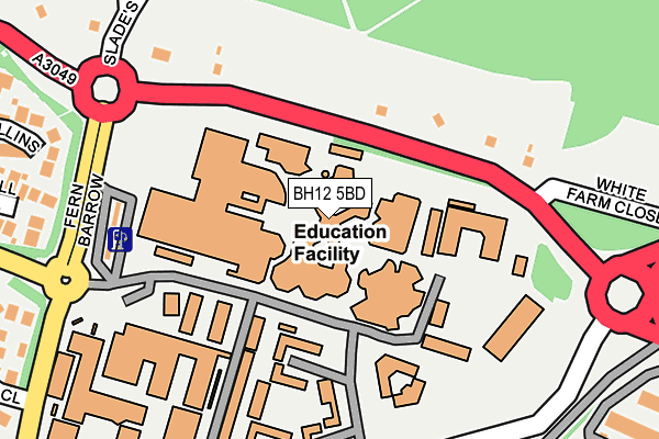
BH12 5BD is located in the Talbot & Branksome Woods electoral ward, within the unitary authority of Bournemouth, Christchurch and Poole and the English Parliamentary constituency of Bournemouth West. The Sub Integrated Care Board (ICB) Location is NHS Dorset ICB - 11J and the police force is Dorset. This postcode has been in use since June 2011.


GetTheData
Source: OS OpenMap – Local (Ordnance Survey)
Source: OS VectorMap District (Ordnance Survey)
Licence: Open Government Licence (requires attribution)
| Easting | 407478 |
| Northing | 93745 |
| Latitude | 50.743254 |
| Longitude | -1.895373 |
GetTheData
Source: Open Postcode Geo
Licence: Open Government Licence
| Country | England |
| Postcode District | BH12 |
| ➜ BH12 open data dashboard ➜ See where BH12 is on a map ➜ Where is Poole? | |
GetTheData
Source: Land Registry Price Paid Data
Licence: Open Government Licence
Elevation or altitude of BH12 5BD as distance above sea level:
| Metres | Feet | |
|---|---|---|
| Elevation | 50m | 164ft |
Elevation is measured from the approximate centre of the postcode, to the nearest point on an OS contour line from OS Terrain 50, which has contour spacing of ten vertical metres.
➜ How high above sea level am I? Find the elevation of your current position using your device's GPS.
GetTheData
Source: Open Postcode Elevation
Licence: Open Government Licence
| Ward | Talbot & Branksome Woods |
| Constituency | Bournemouth West |
GetTheData
Source: ONS Postcode Database
Licence: Open Government Licence
| August 2023 | Vehicle crime | On or near Vine Farm Close | 430m |
| August 2023 | Other theft | On or near Vine Farm Close | 430m |
| April 2023 | Anti-social behaviour | On or near Vine Farm Close | 430m |
| ➜ Get more crime data in our Crime section | |||
GetTheData
Source: data.police.uk
Licence: Open Government Licence
| Bournemouth University (Wallisdown Road) | Talbot Heath | 108m |
| Bournemouth University (Fern Barrow) | Talbot Heath | 227m |
| Bournemouth University | Talbot Heath | 248m |
| Bournemouth University | Talbot Heath | 303m |
| Talbot Manor (Talbot Avenue) | Talbot Woods | 333m |
| Branksome Station | 2.5km |
| Bournemouth Station | 2.8km |
| Parkstone (Dorset) Station | 4.3km |
GetTheData
Source: NaPTAN
Licence: Open Government Licence
GetTheData
Source: ONS Postcode Database
Licence: Open Government Licence


➜ Get more ratings from the Food Standards Agency
GetTheData
Source: Food Standards Agency
Licence: FSA terms & conditions
| Last Collection | |||
|---|---|---|---|
| Location | Mon-Fri | Sat | Distance |
| Fernbarrow | 17:30 | 12:30 | 330m |
| Woodview Road | 17:45 | 11:45 | 492m |
| Ensbury Ave | 17:30 | 11:30 | 627m |
GetTheData
Source: Dracos
Licence: Creative Commons Attribution-ShareAlike
| Facility | Distance |
|---|---|
| Bournemouth University Sports Centre Fern Barrow, Poole Sports Hall, Health and Fitness Gym, Studio, Artificial Grass Pitch | 130m |
| Bournemouth Velodrome Ensbury Avenue, Bournemouth Cycling | 421m |
| Slades Park Ensbury Avenue, Bournemouth Grass Pitches, Artificial Grass Pitch | 528m |
GetTheData
Source: Active Places
Licence: Open Government Licence
| School | Phase of Education | Distance |
|---|---|---|
| Bournemouth University Poole House, Talbot Campus, Fern Barrow, Poole, BH12 5BB | Not applicable | 130m |
| Arts University Bournemouth Wallisdown Road, Poole, BH12 5HH | Not applicable | 232m |
| St Mark's Church of England Primary School Talbot Village, Bournemouth, BH10 4JA | Primary | 473m |
GetTheData
Source: Edubase
Licence: Open Government Licence
The below table lists the International Territorial Level (ITL) codes (formerly Nomenclature of Territorial Units for Statistics (NUTS) codes) and Local Administrative Units (LAU) codes for BH12 5BD:
| ITL 1 Code | Name |
|---|---|
| TLK | South West (England) |
| ITL 2 Code | Name |
| TLK2 | Dorset and Somerset |
| ITL 3 Code | Name |
| TLK24 | Bournemouth, Christchurch and Poole |
| LAU 1 Code | Name |
| E06000058 | Bournemouth, Christchurch and Poole |
GetTheData
Source: ONS Postcode Directory
Licence: Open Government Licence
The below table lists the Census Output Area (OA), Lower Layer Super Output Area (LSOA), and Middle Layer Super Output Area (MSOA) for BH12 5BD:
| Code | Name | |
|---|---|---|
| OA | E00077804 | |
| LSOA | E01015388 | Poole 009C |
| MSOA | E02003202 | Poole 009 |
GetTheData
Source: ONS Postcode Directory
Licence: Open Government Licence
| BH12 5EG | Cull Close | 292m |
| BH12 5EQ | Mullins Close | 294m |
| BH12 5EF | Marianne Road | 341m |
| BH12 5HP | Mcwilliam Close | 378m |
| BH3 7DR | Roslin Gardens | 405m |
| BH3 7HT | Talbot Avenue | 414m |
| BH9 2LT | Firs Glen Road | 415m |
| BH3 7EA | Dulsie Road | 417m |
| BH12 5EJ | Vine Farm Close | 418m |
| BH12 5EH | Georgina Close | 423m |
GetTheData
Source: Open Postcode Geo; Land Registry Price Paid Data
Licence: Open Government Licence