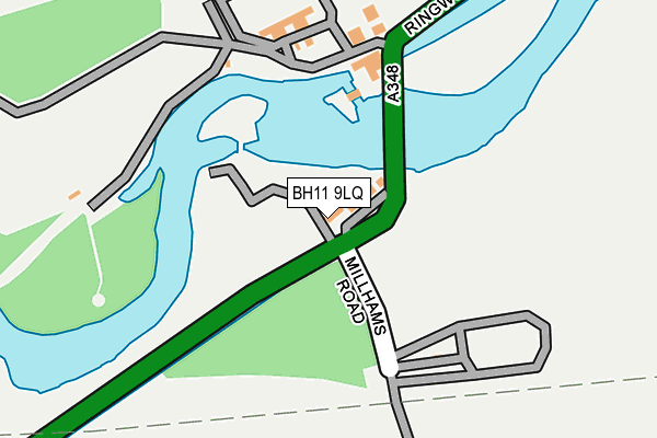
BH11 9LQ lies on Ringwood Road in Bournemouth. BH11 9LQ is located in the Bearwood & Merley electoral ward, within the unitary authority of Bournemouth, Christchurch and Poole and the English Parliamentary constituency of Bournemouth West. The Sub Integrated Care Board (ICB) Location is NHS Dorset ICB - 11J and the police force is Dorset. This postcode has been in use since January 1980.


GetTheData
Source: OS OpenMap – Local (Ordnance Survey)
Source: OS VectorMap District (Ordnance Survey)
Licence: Open Government Licence (requires attribution)
| Easting | 406371 |
| Northing | 97220 |
| Latitude | 50.774528 |
| Longitude | -1.911012 |
GetTheData
Source: Open Postcode Geo
Licence: Open Government Licence
| Street | Ringwood Road |
| Town/City | Bournemouth |
| Country | England |
| Postcode District | BH11 |
| ➜ BH11 open data dashboard ➜ See where BH11 is on a map ➜ Where is Bournemouth? | |
GetTheData
Source: Land Registry Price Paid Data
Licence: Open Government Licence
Elevation or altitude of BH11 9LQ as distance above sea level:
| Metres | Feet | |
|---|---|---|
| Elevation | 10m | 33ft |
Elevation is measured from the approximate centre of the postcode, to the nearest point on an OS contour line from OS Terrain 50, which has contour spacing of ten vertical metres.
➜ How high above sea level am I? Find the elevation of your current position using your device's GPS.
GetTheData
Source: Open Postcode Elevation
Licence: Open Government Licence
| Ward | Bearwood & Merley |
| Constituency | Bournemouth West |
GetTheData
Source: ONS Postcode Database
Licence: Open Government Licence
| Bridge House Hotel (Ringwood Road) | Longham | 239m |
| Longham Bridge (Ringwood Road) | Longham | 244m |
| Kings Arms (Ringwood Road) | Longham | 534m |
| Kings Arms | Longham | 582m |
| Durdells Avenue | Kinson | 605m |
GetTheData
Source: NaPTAN
Licence: Open Government Licence
| Percentage of properties with Next Generation Access | 100.0% |
| Percentage of properties with Superfast Broadband | 100.0% |
| Percentage of properties with Ultrafast Broadband | 0.0% |
| Percentage of properties with Full Fibre Broadband | 0.0% |
Superfast Broadband is between 30Mbps and 300Mbps
Ultrafast Broadband is > 300Mbps
| Percentage of properties unable to receive 2Mbps | 0.0% |
| Percentage of properties unable to receive 5Mbps | 0.0% |
| Percentage of properties unable to receive 10Mbps | 0.0% |
| Percentage of properties unable to receive 30Mbps | 0.0% |
GetTheData
Source: Ofcom
Licence: Ofcom Terms of Use (requires attribution)
GetTheData
Source: ONS Postcode Database
Licence: Open Government Licence


➜ Get more ratings from the Food Standards Agency
GetTheData
Source: Food Standards Agency
Licence: FSA terms & conditions
| Last Collection | |||
|---|---|---|---|
| Location | Mon-Fri | Sat | Distance |
| Longham Village | 16:00 | 11:30 | 531m |
| Durdells Ave | 17:30 | 12:45 | 655m |
| Wimborne Orad | 17:30 | 12:45 | 739m |
GetTheData
Source: Dracos
Licence: Creative Commons Attribution-ShareAlike
| Facility | Distance |
|---|---|
| Kinson Community Centre Pelhams Park, Millhams Road, Bournemouth Sports Hall | 757m |
| Pelhams Park Leisure Centre Manor Farm Road, Bournemouth Swimming Pool, Health and Fitness Gym, Grass Pitches, Studio, Artificial Grass Pitch, Outdoor Tennis Courts | 879m |
| Christ The King Catholic Primary School Durdells Avenue, Bournemouth Grass Pitches, Artificial Grass Pitch | 886m |
GetTheData
Source: Active Places
Licence: Open Government Licence
| School | Phase of Education | Distance |
|---|---|---|
| Christ The King Catholic Primary School Durdells Avenue, Kinson, Bournemouth, BH11 9EH | Primary | 885m |
| Kinson Academy School Lane, Kinson, Bournemouth, BH11 9DG | Primary | 957m |
| LeAF Studio Holloway Avenue, Bournemouth, BH11 9JW | Secondary | 1.3km |
GetTheData
Source: Edubase
Licence: Open Government Licence
| Risk of BH11 9LQ flooding from rivers and sea | High |
| ➜ BH11 9LQ flood map | |
GetTheData
Source: Open Flood Risk by Postcode
Licence: Open Government Licence
The below table lists the International Territorial Level (ITL) codes (formerly Nomenclature of Territorial Units for Statistics (NUTS) codes) and Local Administrative Units (LAU) codes for BH11 9LQ:
| ITL 1 Code | Name |
|---|---|
| TLK | South West (England) |
| ITL 2 Code | Name |
| TLK2 | Dorset and Somerset |
| ITL 3 Code | Name |
| TLK24 | Bournemouth, Christchurch and Poole |
| LAU 1 Code | Name |
| E06000058 | Bournemouth, Christchurch and Poole |
GetTheData
Source: ONS Postcode Directory
Licence: Open Government Licence
The below table lists the Census Output Area (OA), Lower Layer Super Output Area (LSOA), and Middle Layer Super Output Area (MSOA) for BH11 9LQ:
| Code | Name | |
|---|---|---|
| OA | E00077369 | |
| LSOA | E01015302 | Bournemouth 002A |
| MSOA | E02003173 | Bournemouth 002 |
GetTheData
Source: ONS Postcode Directory
Licence: Open Government Licence
| BH22 9AN | Ringwood Road | 411m |
| BH22 9AA | Ringwood Road | 487m |
| BH11 9DL | Garsdale Close | 516m |
| BH11 9BT | Berrans Avenue | 531m |
| BH11 9BY | Cudnell Avenue | 533m |
| BH11 9BZ | Cudnell Avenue | 566m |
| BH11 9DN | Garsdale Close | 583m |
| BH10 7LW | Millhams Close | 594m |
| BH11 9AS | Wimborne Road | 597m |
| BH10 7LP | Millhams Drive | 599m |
GetTheData
Source: Open Postcode Geo; Land Registry Price Paid Data
Licence: Open Government Licence