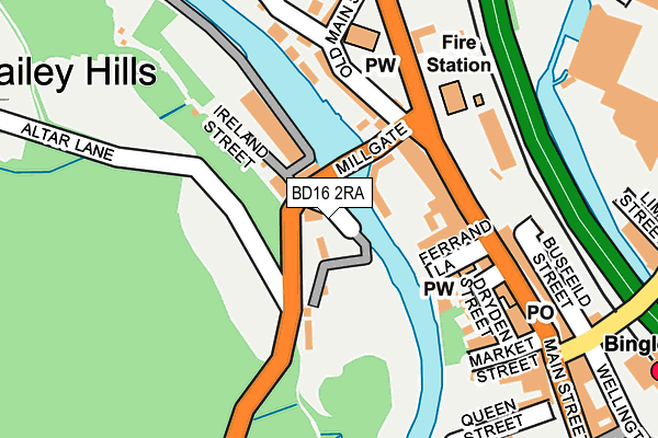
BD16 2RA is located in the Bingley electoral ward, within the metropolitan district of Bradford and the English Parliamentary constituency of Shipley. The Sub Integrated Care Board (ICB) Location is NHS West Yorkshire ICB - 36J and the police force is West Yorkshire. This postcode has been in use since January 1980.


GetTheData
Source: OS OpenMap – Local (Ordnance Survey)
Source: OS VectorMap District (Ordnance Survey)
Licence: Open Government Licence (requires attribution)
| Easting | 410516 |
| Northing | 439304 |
| Latitude | 53.849882 |
| Longitude | -1.841637 |
GetTheData
Source: Open Postcode Geo
Licence: Open Government Licence
| Country | England |
| Postcode District | BD16 |
| ➜ BD16 open data dashboard ➜ See where BD16 is on a map ➜ Where is Bingley? | |
GetTheData
Source: Land Registry Price Paid Data
Licence: Open Government Licence
Elevation or altitude of BD16 2RA as distance above sea level:
| Metres | Feet | |
|---|---|---|
| Elevation | 80m | 262ft |
Elevation is measured from the approximate centre of the postcode, to the nearest point on an OS contour line from OS Terrain 50, which has contour spacing of ten vertical metres.
➜ How high above sea level am I? Find the elevation of your current position using your device's GPS.
GetTheData
Source: Open Postcode Elevation
Licence: Open Government Licence
| Ward | Bingley |
| Constituency | Shipley |
GetTheData
Source: ONS Postcode Database
Licence: Open Government Licence
| December 2023 | Robbery | On or near Parking Area | 378m |
| November 2023 | Drugs | On or near Parking Area | 378m |
| November 2023 | Violence and sexual offences | On or near Parking Area | 378m |
| ➜ Get more crime data in our Crime section | |||
GetTheData
Source: data.police.uk
Licence: Open Government Licence
| Brown Cow Ph Harden Rd (Harden Road) | Bingley | 36m |
| Brown Cow Ph Harden Rd (Harden Road) | Bingley | 46m |
| Midland Hotel (Main Street) | Bingley | 194m |
| Midland Hotel (Main Street) | Bingley | 196m |
| Keighley Rd Old Main Street (Keighley Road) | Bingley | 203m |
| Bingley Station | 0.3km |
| Crossflatts Station | 1km |
| Saltaire Station | 3.6km |
GetTheData
Source: NaPTAN
Licence: Open Government Licence
GetTheData
Source: ONS Postcode Database
Licence: Open Government Licence


➜ Get more ratings from the Food Standards Agency
GetTheData
Source: Food Standards Agency
Licence: FSA terms & conditions
| Last Collection | |||
|---|---|---|---|
| Location | Mon-Fri | Sat | Distance |
| Millgate | 17:30 | 11:45 | 109m |
| Bingley Delivery Office Box | 17:30 | 13:00 | 231m |
| Jet Ppb | 16:30 | 11:45 | 276m |
GetTheData
Source: Dracos
Licence: Creative Commons Attribution-ShareAlike
| Facility | Distance |
|---|---|
| Club M (Closed) Wellington Street, Bingley Studio, Health and Fitness Gym | 321m |
| Flacks Fit 24 Wellington Street, Bingley Health and Fitness Gym, Studio | 339m |
| Bingley Swimming Pool Myrtle Place, Bingley Swimming Pool, Health and Fitness Gym | 355m |
GetTheData
Source: Active Places
Licence: Open Government Licence
| School | Phase of Education | Distance |
|---|---|---|
| Beckfoot Priestthorpe Primary School & Nursery Mornington Road, Bingley, BD16 4JS | Primary | 603m |
| Myrtle Park Primary Ash Terrace, Bingley, BD16 1HB | Primary | 681m |
| Bingley Grammar School Keighley Road, Bingley, BD16 2RS | Secondary | 719m |
GetTheData
Source: Edubase
Licence: Open Government Licence
| Risk of BD16 2RA flooding from rivers and sea | Medium |
| ➜ BD16 2RA flood map | |
GetTheData
Source: Open Flood Risk by Postcode
Licence: Open Government Licence
The below table lists the International Territorial Level (ITL) codes (formerly Nomenclature of Territorial Units for Statistics (NUTS) codes) and Local Administrative Units (LAU) codes for BD16 2RA:
| ITL 1 Code | Name |
|---|---|
| TLE | Yorkshire and The Humber |
| ITL 2 Code | Name |
| TLE4 | West Yorkshire |
| ITL 3 Code | Name |
| TLE41 | Bradford |
| LAU 1 Code | Name |
| E08000032 | Bradford |
GetTheData
Source: ONS Postcode Directory
Licence: Open Government Licence
The below table lists the Census Output Area (OA), Lower Layer Super Output Area (LSOA), and Middle Layer Super Output Area (MSOA) for BD16 2RA:
| Code | Name | |
|---|---|---|
| OA | E00053415 | |
| LSOA | E01010578 | Bradford 015A |
| MSOA | E02002197 | Bradford 015 |
GetTheData
Source: ONS Postcode Directory
Licence: Open Government Licence
| BD16 2JW | Millgate | 47m |
| BD16 2QX | Ireland Bridge | 49m |
| BD16 2QY | Ireland Street | 61m |
| BD16 2QZ | Ireland Terrace | 63m |
| BD16 2QE | Ireland Street | 69m |
| BD16 2QD | Ireland Street | 97m |
| BD16 2JN | Ferrand Lane | 97m |
| BD16 2JH | Main Street | 100m |
| BD16 1AP | Harden Road | 101m |
| BD16 2JP | Ferrand Lane | 114m |
GetTheData
Source: Open Postcode Geo; Land Registry Price Paid Data
Licence: Open Government Licence