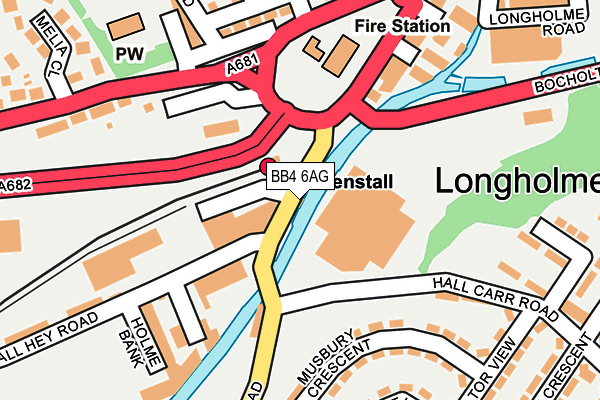
BB4 6AG is located in the Longholme electoral ward, within the local authority district of Rossendale and the English Parliamentary constituency of Rossendale and Darwen. The Sub Integrated Care Board (ICB) Location is NHS Lancashire and South Cumbria ICB - 01A and the police force is Lancashire. This postcode has been in use since January 1980.


GetTheData
Source: OS OpenMap – Local (Ordnance Survey)
Source: OS VectorMap District (Ordnance Survey)
Licence: Open Government Licence (requires attribution)
| Easting | 380969 |
| Northing | 422505 |
| Latitude | 53.698632 |
| Longitude | -2.289721 |
GetTheData
Source: Open Postcode Geo
Licence: Open Government Licence
| Country | England |
| Postcode District | BB4 |
| ➜ BB4 open data dashboard ➜ See where BB4 is on a map ➜ Where is Rawtenstall? | |
GetTheData
Source: Land Registry Price Paid Data
Licence: Open Government Licence
Elevation or altitude of BB4 6AG as distance above sea level:
| Metres | Feet | |
|---|---|---|
| Elevation | 170m | 558ft |
Elevation is measured from the approximate centre of the postcode, to the nearest point on an OS contour line from OS Terrain 50, which has contour spacing of ten vertical metres.
➜ How high above sea level am I? Find the elevation of your current position using your device's GPS.
GetTheData
Source: Open Postcode Elevation
Licence: Open Government Licence
| Ward | Longholme |
| Constituency | Rossendale And Darwen |
GetTheData
Source: ONS Postcode Database
Licence: Open Government Licence
| January 2024 | Anti-social behaviour | On or near Petrol Station | 260m |
| January 2024 | Anti-social behaviour | On or near Petrol Station | 260m |
| January 2024 | Anti-social behaviour | On or near Petrol Station | 260m |
| ➜ Get more crime data in our Crime section | |||
GetTheData
Source: data.police.uk
Licence: Open Government Licence
| Railway Station (Bury Road) | Rawtenstall | 11m |
| Railway Station (Bury Road) | Rawtenstall | 39m |
| Fire Station (Haslingden Road) | Rawtenstall | 135m |
| Hall Carr Road | Hall Carr | 150m |
| Magistrates Court (Haslingden Road) | Rawtenstall | 178m |
| Rawtenstall (East Lancashire Railway) | Longholme | 65m |
GetTheData
Source: NaPTAN
Licence: Open Government Licence
GetTheData
Source: ONS Postcode Database
Licence: Open Government Licence


➜ Get more ratings from the Food Standards Agency
GetTheData
Source: Food Standards Agency
Licence: FSA terms & conditions
| Last Collection | |||
|---|---|---|---|
| Location | Mon-Fri | Sat | Distance |
| Railway Station | 16:45 | 12:30 | 40m |
| Rossendale Delivery Office | 17:45 | 13:00 | 509m |
| Helmshore Post Office | 16:45 | 11:45 | 1,403m |
GetTheData
Source: Dracos
Licence: Creative Commons Attribution-ShareAlike
| Facility | Distance |
|---|---|
| Accrington And Rossendale College (Haslingden Road Campus) (Closed) Haslingden Road, Rawtenstall, Rossendale Sports Hall | 119m |
| Thrive Gym (Rawtenstall) New Hall Hey Road, Rawtenstall, Rossendale Health and Fitness Gym, Studio | 198m |
| New Hall Hey Cricket Ground New Hall Hey Road, Rawtenstall, Rossendale Grass Pitches | 219m |
GetTheData
Source: Active Places
Licence: Open Government Licence
| School | Phase of Education | Distance |
|---|---|---|
| St James-the-Less Roman Catholic Primary School, Rawtenstall Unity Way, Rawtenstall, Rossendale, BB4 8SU | Primary | 643m |
| Rawtenstall Balladen Community Primary School Linden Lea, Rawtenstall, Rossendale, BB4 6DX | Primary | 647m |
| St Mary's CofE Primary School Rawtenstall Haslingden Old Road, Rawtenstall, St. Marys C of E School, ROSSENDALE, BB4 8RZ | Primary | 659m |
GetTheData
Source: Edubase
Licence: Open Government Licence
| Risk of BB4 6AG flooding from rivers and sea | Low |
| ➜ BB4 6AG flood map | |
GetTheData
Source: Open Flood Risk by Postcode
Licence: Open Government Licence
The below table lists the International Territorial Level (ITL) codes (formerly Nomenclature of Territorial Units for Statistics (NUTS) codes) and Local Administrative Units (LAU) codes for BB4 6AG:
| ITL 1 Code | Name |
|---|---|
| TLD | North West (England) |
| ITL 2 Code | Name |
| TLD4 | Lancashire |
| ITL 3 Code | Name |
| TLD46 | East Lancashire |
| LAU 1 Code | Name |
| E07000125 | Rossendale |
GetTheData
Source: ONS Postcode Directory
Licence: Open Government Licence
The below table lists the Census Output Area (OA), Lower Layer Super Output Area (LSOA), and Middle Layer Super Output Area (MSOA) for BB4 6AG:
| Code | Name | |
|---|---|---|
| OA | E00128841 | |
| LSOA | E01033281 | Rossendale 004G |
| MSOA | E02005281 | Rossendale 004 |
GetTheData
Source: ONS Postcode Directory
Licence: Open Government Licence
| BB4 6HQ | Foundry Street | 159m |
| BB4 6AY | Musbury Crescent | 174m |
| BB4 6QZ | Cow Lane | 179m |
| BB4 6HJ | Holme Bank | 195m |
| BB4 6AF | Parramatta Street | 195m |
| BB4 6QX | Haslingden Road | 203m |
| BB4 6AA | Bury Road | 206m |
| BB4 8SN | Gordon Street | 234m |
| BB4 8SH | St Marys Place | 243m |
| BB4 6AD | Queen Street | 243m |
GetTheData
Source: Open Postcode Geo; Land Registry Price Paid Data
Licence: Open Government Licence