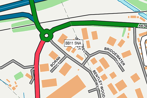
BB11 5NA is located in the Hapton with Park electoral ward, within the local authority district of Burnley and the English Parliamentary constituency of Burnley. The Sub Integrated Care Board (ICB) Location is NHS Lancashire and South Cumbria ICB - 01A and the police force is Lancashire. This postcode has been in use since October 2008.


GetTheData
Source: OS OpenMap – Local (Ordnance Survey)
Source: OS VectorMap District (Ordnance Survey)
Licence: Open Government Licence (requires attribution)
| Easting | 380522 |
| Northing | 431857 |
| Latitude | 53.782670 |
| Longitude | -2.297084 |
GetTheData
Source: Open Postcode Geo
Licence: Open Government Licence
| Country | England |
| Postcode District | BB11 |
| ➜ BB11 open data dashboard ➜ See where BB11 is on a map ➜ Where is Hapton? | |
GetTheData
Source: Land Registry Price Paid Data
Licence: Open Government Licence
Elevation or altitude of BB11 5NA as distance above sea level:
| Metres | Feet | |
|---|---|---|
| Elevation | 150m | 492ft |
Elevation is measured from the approximate centre of the postcode, to the nearest point on an OS contour line from OS Terrain 50, which has contour spacing of ten vertical metres.
➜ How high above sea level am I? Find the elevation of your current position using your device's GPS.
GetTheData
Source: Open Postcode Elevation
Licence: Open Government Licence
| Ward | Hapton With Park |
| Constituency | Burnley |
GetTheData
Source: ONS Postcode Database
Licence: Open Government Licence
| June 2022 | Burglary | On or near Boran Court | 84m |
| June 2022 | Other theft | On or near Boran Court | 84m |
| June 2022 | Violence and sexual offences | On or near Valley Gardens | 338m |
| ➜ Get more crime data in our Crime section | |||
GetTheData
Source: data.police.uk
Licence: Open Government Licence
| Bentleywood Way (Bentley-wood Way) | Lowerhouse | 53m |
| Bentley Wood Way | Lowerhouse | 54m |
| Network 65 (Burnley Road) | Hapton | 139m |
| Network 65 (Burnley Road) | Hapton | 151m |
| Bridgewater Close | Lowerhouse | 201m |
| Rose Grove Station | 1km |
| Hapton Station | 1.3km |
| Burnley Barracks Station | 2.7km |
GetTheData
Source: NaPTAN
Licence: Open Government Licence
| Median download speed | 80.0Mbps |
| Average download speed | 73.1Mbps |
| Maximum download speed | 80.00Mbps |
| Median upload speed | 20.0Mbps |
| Average upload speed | 18.8Mbps |
| Maximum upload speed | 20.00Mbps |
GetTheData
Source: Ofcom
Licence: Ofcom Terms of Use (requires attribution)
Estimated total energy consumption in BB11 5NA by fuel type, 2015.
| Consumption (kWh) | 139,264 |
|---|---|
| Meter count | 11 |
| Mean (kWh/meter) | 12,660 |
| Median (kWh/meter) | 12,726 |
GetTheData
Source: Postcode level gas estimates: 2015 (experimental)
Source: Postcode level electricity estimates: 2015 (experimental)
Licence: Open Government Licence
GetTheData
Source: ONS Postcode Database
Licence: Open Government Licence


➜ Get more ratings from the Food Standards Agency
GetTheData
Source: Food Standards Agency
Licence: FSA terms & conditions
| Last Collection | |||
|---|---|---|---|
| Location | Mon-Fri | Sat | Distance |
| 81 Rosegrove Lane | 16:00 | 11:00 | 1,089m |
| Farrington Road | 18:00 | 11:00 | 1,204m |
| Padiham Bridge | 17:30 | 11:00 | 1,973m |
GetTheData
Source: Dracos
Licence: Creative Commons Attribution-ShareAlike
| Facility | Distance |
|---|---|
| Lowerhouse Cricket Club - The Brooks Foundation Ground David Wren Way Off Lowerhouse Lane, Burnley Grass Pitches | 1km |
| Hameldon Community College (Site 1) (Closed) Byron Street, Burnley Grass Pitches, Sports Hall | 1.3km |
| Habergham Community College (Site 2) (Closed) Byron Street, Burnley Grass Pitches | 1.4km |
GetTheData
Source: Active Places
Licence: Open Government Licence
| School | Phase of Education | Distance |
|---|---|---|
| Rosegrove Infant School Owen Street, Burnley, BB12 6HW | Primary | 1.2km |
| Burnley Lowerhouse Junior School Liverpool Road, Burnley, BB12 6LN | Primary | 1.2km |
| St Augustine of Canterbury RC Primary School, A Voluntary Academy Lowerhouse Lane, Burnley, BB12 6HZ | Primary | 1.3km |
GetTheData
Source: Edubase
Licence: Open Government Licence
The below table lists the International Territorial Level (ITL) codes (formerly Nomenclature of Territorial Units for Statistics (NUTS) codes) and Local Administrative Units (LAU) codes for BB11 5NA:
| ITL 1 Code | Name |
|---|---|
| TLD | North West (England) |
| ITL 2 Code | Name |
| TLD4 | Lancashire |
| ITL 3 Code | Name |
| TLD46 | East Lancashire |
| LAU 1 Code | Name |
| E07000117 | Burnley |
GetTheData
Source: ONS Postcode Directory
Licence: Open Government Licence
The below table lists the Census Output Area (OA), Lower Layer Super Output Area (LSOA), and Middle Layer Super Output Area (MSOA) for BB11 5NA:
| Code | Name | |
|---|---|---|
| OA | E00126322 | |
| LSOA | E01024888 | Burnley 011C |
| MSOA | E02005186 | Burnley 011 |
GetTheData
Source: ONS Postcode Directory
Licence: Open Government Licence
| BB11 5ST | Bentley Wood Way | 243m |
| BB11 5QF | Accrington Road | 271m |
| BB11 5QE | Valley Gardens | 319m |
| BB11 5QG | Accrington Road | 654m |
| BB12 7EJ | Iridium Close | 680m |
| BB12 7BF | Magnesium Way | 687m |
| BB12 6TT | Lower Rosegrove Lane | 705m |
| BB12 6PY | Upper Brook Court | 738m |
| BB11 5QD | Accrington Road | 756m |
| BB12 6PD | Greenbrook Road | 778m |
GetTheData
Source: Open Postcode Geo; Land Registry Price Paid Data
Licence: Open Government Licence