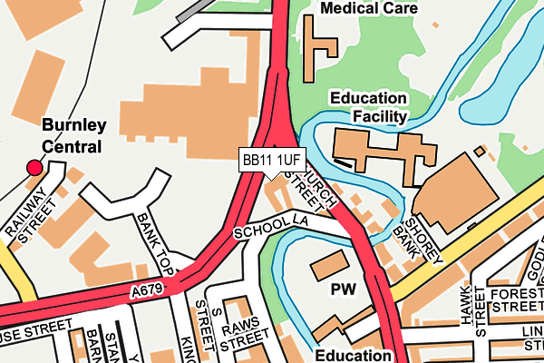
BB11 1UF is located in the Daneshouse with Stoneyholme electoral ward, within the local authority district of Burnley and the English Parliamentary constituency of Burnley. The Sub Integrated Care Board (ICB) Location is NHS Lancashire and South Cumbria ICB - 01A and the police force is Lancashire. This postcode has been in use since January 1980.


GetTheData
Source: OS OpenMap – Local (Ordnance Survey)
Source: OS VectorMap District (Ordnance Survey)
Licence: Open Government Licence (requires attribution)
| Easting | 384231 |
| Northing | 433048 |
| Latitude | 53.793501 |
| Longitude | -2.240857 |
GetTheData
Source: Open Postcode Geo
Licence: Open Government Licence
| Country | England |
| Postcode District | BB11 |
| ➜ BB11 open data dashboard ➜ See where BB11 is on a map ➜ Where is Burnley? | |
GetTheData
Source: Land Registry Price Paid Data
Licence: Open Government Licence
Elevation or altitude of BB11 1UF as distance above sea level:
| Metres | Feet | |
|---|---|---|
| Elevation | 120m | 394ft |
Elevation is measured from the approximate centre of the postcode, to the nearest point on an OS contour line from OS Terrain 50, which has contour spacing of ten vertical metres.
➜ How high above sea level am I? Find the elevation of your current position using your device's GPS.
GetTheData
Source: Open Postcode Elevation
Licence: Open Government Licence
| Ward | Daneshouse With Stoneyholme |
| Constituency | Burnley |
GetTheData
Source: ONS Postcode Database
Licence: Open Government Licence
| January 2024 | Anti-social behaviour | On or near Bank Parade | 205m |
| January 2024 | Vehicle crime | On or near Bank Parade | 205m |
| January 2024 | Vehicle crime | On or near Bank Parade | 205m |
| ➜ Get more crime data in our Crime section | |||
GetTheData
Source: data.police.uk
Licence: Open Government Licence
| Ormerod Road (Church Street) | Burnley | 116m |
| Prestige Park (Church Street) | Burnley | 131m |
| Ormerod Road (Church Street) | Burnley | 143m |
| Prestige Park (Church Street) | Burnley | 188m |
| Asda (Princess Way) | Stoneyholme | 320m |
| Burnley Central Station | 0.3km |
| Burnley Manchester Road Station | 1.1km |
| Burnley Barracks Station | 1.2km |
GetTheData
Source: NaPTAN
Licence: Open Government Licence
GetTheData
Source: ONS Postcode Database
Licence: Open Government Licence


➜ Get more ratings from the Food Standards Agency
GetTheData
Source: Food Standards Agency
Licence: FSA terms & conditions
| Last Collection | |||
|---|---|---|---|
| Location | Mon-Fri | Sat | Distance |
| Bank Top | 17:30 | 11:00 | 207m |
| Brunshaw Top | 16:00 | 11:00 | 387m |
| Burnley Delivery Office | 19:00 | 13:00 | 564m |
GetTheData
Source: Dracos
Licence: Creative Commons Attribution-ShareAlike
| Facility | Distance |
|---|---|
| Jd Gyms (Burnley) Active Way, Burnley Health and Fitness Gym | 168m |
| Xercise4less (Burnley) (Closed) Kingsway, Burnley Health and Fitness Gym, Studio, Sports Hall | 268m |
| St Peters Centre Church Street, Burnley Swimming Pool, Sports Hall, Health and Fitness Gym, Studio, Squash Courts | 431m |
GetTheData
Source: Active Places
Licence: Open Government Licence
| School | Phase of Education | Distance |
|---|---|---|
| Olive High SHOREY BANK, BURNLEY, BB11 2RY | Not applicable | 147m |
| Burnley St Peter's Church of England Primary School Church Street, Burnley, BB11 2DL | Primary | 272m |
| Burnley College Princess Way, Burnley, BB12 0AN | 16 plus | 588m |
GetTheData
Source: Edubase
Licence: Open Government Licence
The below table lists the International Territorial Level (ITL) codes (formerly Nomenclature of Territorial Units for Statistics (NUTS) codes) and Local Administrative Units (LAU) codes for BB11 1UF:
| ITL 1 Code | Name |
|---|---|
| TLD | North West (England) |
| ITL 2 Code | Name |
| TLD4 | Lancashire |
| ITL 3 Code | Name |
| TLD46 | East Lancashire |
| LAU 1 Code | Name |
| E07000117 | Burnley |
GetTheData
Source: ONS Postcode Directory
Licence: Open Government Licence
The below table lists the Census Output Area (OA), Lower Layer Super Output Area (LSOA), and Middle Layer Super Output Area (MSOA) for BB11 1UF:
| Code | Name | |
|---|---|---|
| OA | E00126261 | |
| LSOA | E01024877 | Burnley 003D |
| MSOA | E02005178 | Burnley 003 |
GetTheData
Source: ONS Postcode Directory
Licence: Open Government Licence
| BB11 2RT | Dawson Square | 110m |
| BB11 2RS | Church Street | 126m |
| BB11 2RY | Shorey Bank | 147m |
| BB11 2AA | Colne Road | 162m |
| BB11 1TS | Bank Parade | 167m |
| BB11 1AU | Parker Street | 206m |
| BB11 1UG | Bank Parade | 218m |
| BB11 2SE | Hawk Street | 257m |
| BB11 2SD | Browns Square | 274m |
| BB11 1AP | Standish Street | 275m |
GetTheData
Source: Open Postcode Geo; Land Registry Price Paid Data
Licence: Open Government Licence