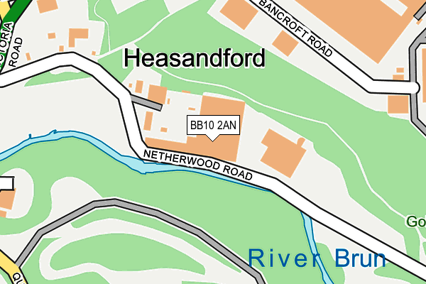
BB10 2AN is located in the Lanehead electoral ward, within the local authority district of Burnley and the English Parliamentary constituency of Burnley. The Sub Integrated Care Board (ICB) Location is NHS Lancashire and South Cumbria ICB - 01A and the police force is Lancashire. This postcode has been in use since January 1980.


GetTheData
Source: OS OpenMap – Local (Ordnance Survey)
Source: OS VectorMap District (Ordnance Survey)
Licence: Open Government Licence (requires attribution)
| Easting | 385361 |
| Northing | 433600 |
| Latitude | 53.798495 |
| Longitude | -2.223730 |
GetTheData
Source: Open Postcode Geo
Licence: Open Government Licence
| Country | England |
| Postcode District | BB10 |
| ➜ BB10 open data dashboard ➜ See where BB10 is on a map ➜ Where is Burnley? | |
GetTheData
Source: Land Registry Price Paid Data
Licence: Open Government Licence
Elevation or altitude of BB10 2AN as distance above sea level:
| Metres | Feet | |
|---|---|---|
| Elevation | 130m | 427ft |
Elevation is measured from the approximate centre of the postcode, to the nearest point on an OS contour line from OS Terrain 50, which has contour spacing of ten vertical metres.
➜ How high above sea level am I? Find the elevation of your current position using your device's GPS.
GetTheData
Source: Open Postcode Elevation
Licence: Open Government Licence
| Ward | Lanehead |
| Constituency | Burnley |
GetTheData
Source: ONS Postcode Database
Licence: Open Government Licence
| January 2024 | Vehicle crime | On or near Ferndale Street | 420m |
| January 2024 | Violence and sexual offences | On or near Ferndale Street | 420m |
| December 2023 | Criminal damage and arson | On or near Ferndale Street | 420m |
| ➜ Get more crime data in our Crime section | |||
GetTheData
Source: data.police.uk
Licence: Open Government Licence
| Melvile Street (Queen Victoria Road) | Browhead | 285m |
| Queen Victoria Road | Browhead | 343m |
| West Street (Queen Victoria Road) | Browhead | 344m |
| Browhead Road (Queen Victoria Road) | Browhead | 349m |
| Browhead Road (Queen Victoria Road) | Browhead | 377m |
| Burnley Central Station | 1.5km |
| Burnley Manchester Road Station | 2.2km |
| Burnley Barracks Station | 2.4km |
GetTheData
Source: NaPTAN
Licence: Open Government Licence
GetTheData
Source: ONS Postcode Database
Licence: Open Government Licence


➜ Get more ratings from the Food Standards Agency
GetTheData
Source: Food Standards Agency
Licence: FSA terms & conditions
| Last Collection | |||
|---|---|---|---|
| Location | Mon-Fri | Sat | Distance |
| Brunshaw Top | 16:00 | 11:00 | 1,089m |
| 340 Colne Road | 17:30 | 11:00 | 1,147m |
| Bank Top | 17:30 | 11:00 | 1,456m |
GetTheData
Source: Dracos
Licence: Creative Commons Attribution-ShareAlike
| Facility | Distance |
|---|---|
| Basnett Street Playing Field Basnett Street, Basnett Street, Burnley Grass Pitches | 428m |
| Queens Park (Burnley) Queens Park Road, Burnley Grass Pitches, Outdoor Tennis Courts | 436m |
| Blessed Trinity Roman Catholic College Ormerod Road, Burnley Grass Pitches | 622m |
GetTheData
Source: Active Places
Licence: Open Government Licence
| School | Phase of Education | Distance |
|---|---|---|
| Basnett Street Nursery School Basnett Street, Basnett Street Nursery School, Burnley, BB10 3ES | Nursery | 331m |
| Heasandford Primary School Williams Road, Burnley, BB10 3DA | Primary | 484m |
| Ridgewood Community High School Eastern Avenue, Burnley, BB10 2AT | Not applicable | 598m |
GetTheData
Source: Edubase
Licence: Open Government Licence
| Risk of BB10 2AN flooding from rivers and sea | High |
| ➜ BB10 2AN flood map | |
GetTheData
Source: Open Flood Risk by Postcode
Licence: Open Government Licence
The below table lists the International Territorial Level (ITL) codes (formerly Nomenclature of Territorial Units for Statistics (NUTS) codes) and Local Administrative Units (LAU) codes for BB10 2AN:
| ITL 1 Code | Name |
|---|---|
| TLD | North West (England) |
| ITL 2 Code | Name |
| TLD4 | Lancashire |
| ITL 3 Code | Name |
| TLD46 | East Lancashire |
| LAU 1 Code | Name |
| E07000117 | Burnley |
GetTheData
Source: ONS Postcode Directory
Licence: Open Government Licence
The below table lists the Census Output Area (OA), Lower Layer Super Output Area (LSOA), and Middle Layer Super Output Area (MSOA) for BB10 2AN:
| Code | Name | |
|---|---|---|
| OA | E00126346 | |
| LSOA | E01024893 | Burnley 002A |
| MSOA | E02005177 | Burnley 002 |
GetTheData
Source: ONS Postcode Directory
Licence: Open Government Licence
| BB10 2RZ | Bancroft Road | 194m |
| BB10 2AH | Netherwood Road | 237m |
| BB10 3EW | Melville Street | 352m |
| BB10 3ES | Basnett Street | 359m |
| BB10 3LB | Queens Park Road | 366m |
| BB10 3ER | West Street | 392m |
| BB10 3DW | Queen Victoria Road | 415m |
| BB10 3EP | Ferndale Street | 428m |
| BB10 3BX | Browhead Road | 438m |
| BB10 3BY | Vincit Street | 439m |
GetTheData
Source: Open Postcode Geo; Land Registry Price Paid Data
Licence: Open Government Licence