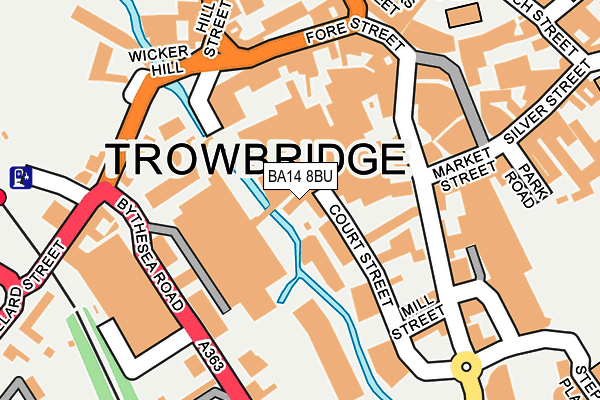
BA14 8BU is located in the Trowbridge Central electoral ward, within the unitary authority of Wiltshire and the English Parliamentary constituency of South West Wiltshire. The Sub Integrated Care Board (ICB) Location is NHS Bath and North East Somerset, Swindon and Wiltshire ICB - 92 and the police force is Wiltshire. This postcode has been in use since December 2001.


GetTheData
Source: OS OpenMap – Local (Ordnance Survey)
Source: OS VectorMap District (Ordnance Survey)
Licence: Open Government Licence (requires attribution)
| Easting | 385477 |
| Northing | 157878 |
| Latitude | 51.319816 |
| Longitude | -2.209782 |
GetTheData
Source: Open Postcode Geo
Licence: Open Government Licence
| Country | England |
| Postcode District | BA14 |
| ➜ BA14 open data dashboard ➜ See where BA14 is on a map ➜ Where is Trowbridge? | |
GetTheData
Source: Land Registry Price Paid Data
Licence: Open Government Licence
Elevation or altitude of BA14 8BU as distance above sea level:
| Metres | Feet | |
|---|---|---|
| Elevation | 40m | 131ft |
Elevation is measured from the approximate centre of the postcode, to the nearest point on an OS contour line from OS Terrain 50, which has contour spacing of ten vertical metres.
➜ How high above sea level am I? Find the elevation of your current position using your device's GPS.
GetTheData
Source: Open Postcode Elevation
Licence: Open Government Licence
| Ward | Trowbridge Central |
| Constituency | South West Wiltshire |
GetTheData
Source: ONS Postcode Database
Licence: Open Government Licence
| January 2024 | Anti-social behaviour | On or near Parking Area | 108m |
| January 2024 | Anti-social behaviour | On or near Parking Area | 108m |
| January 2024 | Bicycle theft | On or near Parking Area | 108m |
| ➜ Get more crime data in our Crime section | |||
GetTheData
Source: data.police.uk
Licence: Open Government Licence
| Castle Street | Trowbridge | 129m |
| Town Hall (Market Street) | Trowbridge | 146m |
| Town Hall (Market Street) | Trowbridge | 161m |
| Town Bridge (Stallard Street) | Trowbridge | 174m |
| Town Hall (Market Street) | Trowbridge | 177m |
| Trowbridge Station | 0.3km |
| Bradford-on-Avon Station | 4.1km |
| Avoncliff Station | 5.5km |
GetTheData
Source: NaPTAN
Licence: Open Government Licence
GetTheData
Source: ONS Postcode Database
Licence: Open Government Licence


➜ Get more ratings from the Food Standards Agency
GetTheData
Source: Food Standards Agency
Licence: FSA terms & conditions
| Last Collection | |||
|---|---|---|---|
| Location | Mon-Fri | Sat | Distance |
| Asda Store | 16:00 | 11:30 | 56m |
| Newtown | 17:30 | 11:30 | 425m |
| Trowbridge Post Office | 18:00 | 13:00 | 454m |
GetTheData
Source: Dracos
Licence: Creative Commons Attribution-ShareAlike
| Facility | Distance |
|---|---|
| Snap Fitness (Trowbridge) Gateway Shopping Park, , Bythesea Road Unit F, Trowbridge Health and Fitness Gym | 104m |
| Anytime Fitness (Trowbridge) Fore Street, Trowbridge Health and Fitness Gym, Studio | 181m |
| Castle Place Leisure Centre Castle Place, Trowbridge Health and Fitness Gym, Studio, Squash Courts | 206m |
GetTheData
Source: Active Places
Licence: Open Government Licence
| School | Phase of Education | Distance |
|---|---|---|
| Newtown Community Primary School Newtown, Trowbridge, BA14 0BB | Primary | 387m |
| St John's Catholic Primary School, Trowbridge Wingfield Road, Trowbridge, BA14 9EA | Primary | 486m |
| St Augustine's Catholic College Wingfield Road, Trowbridge, BA14 9EN | Secondary | 767m |
GetTheData
Source: Edubase
Licence: Open Government Licence
| Risk of BA14 8BU flooding from rivers and sea | Medium |
| ➜ BA14 8BU flood map | |
GetTheData
Source: Open Flood Risk by Postcode
Licence: Open Government Licence
The below table lists the International Territorial Level (ITL) codes (formerly Nomenclature of Territorial Units for Statistics (NUTS) codes) and Local Administrative Units (LAU) codes for BA14 8BU:
| ITL 1 Code | Name |
|---|---|
| TLK | South West (England) |
| ITL 2 Code | Name |
| TLK1 | Gloucestershire, Wiltshire and Bath/Bristol area |
| ITL 3 Code | Name |
| TLK15 | Wiltshire |
| LAU 1 Code | Name |
| E06000054 | Wiltshire |
GetTheData
Source: ONS Postcode Directory
Licence: Open Government Licence
The below table lists the Census Output Area (OA), Lower Layer Super Output Area (LSOA), and Middle Layer Super Output Area (MSOA) for BA14 8BU:
| Code | Name | |
|---|---|---|
| OA | E00166376 | |
| LSOA | E01032086 | Wiltshire 031B |
| MSOA | E02006684 | Wiltshire 031 |
GetTheData
Source: ONS Postcode Directory
Licence: Open Government Licence
| BA14 8BD | Home Mill Buildings | 80m |
| BA14 8HN | Stallard Street | 110m |
| BA14 8JS | Wicker Hill | 127m |
| BA14 8AS | Castle Street | 133m |
| BA14 8EY | Market Street | 138m |
| BA14 8HR | Bythesea Road | 148m |
| BA14 8HD | Fore Street | 153m |
| BA14 8AU | Castle Street | 160m |
| BA14 8JU | Wicker Hill | 163m |
| BA14 8GD | Stallard Street | 164m |
GetTheData
Source: Open Postcode Geo; Land Registry Price Paid Data
Licence: Open Government Licence