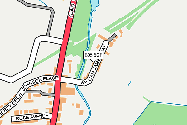
B95 5GF is located in the Henley-in-Arden electoral ward, within the local authority district of Stratford-on-Avon and the English Parliamentary constituency of Stratford-on-Avon. The Sub Integrated Care Board (ICB) Location is NHS Coventry and Warwickshire ICB - B2M3M and the police force is Warwickshire. This postcode has been in use since February 2008.


GetTheData
Source: OS OpenMap – Local (Ordnance Survey)
Source: OS VectorMap District (Ordnance Survey)
Licence: Open Government Licence (requires attribution)
| Easting | 415327 |
| Northing | 266588 |
| Latitude | 52.297208 |
| Longitude | -1.776675 |
GetTheData
Source: Open Postcode Geo
Licence: Open Government Licence
| Country | England |
| Postcode District | B95 |
| ➜ B95 open data dashboard ➜ See where B95 is on a map ➜ Where is Henley-in-Arden? | |
GetTheData
Source: Land Registry Price Paid Data
Licence: Open Government Licence
Elevation or altitude of B95 5GF as distance above sea level:
| Metres | Feet | |
|---|---|---|
| Elevation | 80m | 262ft |
Elevation is measured from the approximate centre of the postcode, to the nearest point on an OS contour line from OS Terrain 50, which has contour spacing of ten vertical metres.
➜ How high above sea level am I? Find the elevation of your current position using your device's GPS.
GetTheData
Source: Open Postcode Elevation
Licence: Open Government Licence
| Ward | Henley-in-arden |
| Constituency | Stratford-on-avon |
GetTheData
Source: ONS Postcode Database
Licence: Open Government Licence
| June 2022 | Vehicle crime | On or near Millfield Court | 101m |
| June 2022 | Vehicle crime | On or near Ashbury Court | 280m |
| June 2022 | Violence and sexual offences | On or near Cherry Orchard | 360m |
| ➜ Get more crime data in our Crime section | |||
GetTheData
Source: data.police.uk
Licence: Open Government Licence
| Three Tuns (High Street) | Henley-in-arden | 425m |
| Three Tuns (High Street) | Henley-in-arden | 450m |
| The Virgins (Birmingham Road) | Henley-in-arden | 632m |
| The Virgins (Birmingham Road) | Henley-in-arden | 689m |
| Arden Road (Castle Road) | Henley-in-arden | 766m |
| Henley-in-Arden Station | 0.8km |
| Wootton Wawen Station | 3.4km |
| Danzey Station | 4.3km |
GetTheData
Source: NaPTAN
Licence: Open Government Licence
| Median download speed | 80.0Mbps |
| Average download speed | 64.1Mbps |
| Maximum download speed | 80.00Mbps |
| Median upload speed | 20.0Mbps |
| Average upload speed | 16.0Mbps |
| Maximum upload speed | 20.00Mbps |
GetTheData
Source: Ofcom
Licence: Ofcom Terms of Use (requires attribution)
GetTheData
Source: ONS Postcode Database
Licence: Open Government Licence


➜ Get more ratings from the Food Standards Agency
GetTheData
Source: Food Standards Agency
Licence: FSA terms & conditions
| Last Collection | |||
|---|---|---|---|
| Location | Mon-Fri | Sat | Distance |
| Henley In Arden Post Office | 17:30 | 11:00 | 617m |
| Beaudesert | 10:00 | 07:40 | 1,309m |
| Hunger Hill | 09:00 | 08:30 | 1,657m |
GetTheData
Source: Dracos
Licence: Creative Commons Attribution-ShareAlike
| Facility | Distance |
|---|---|
| Henley-in-arden C Of E Primary School Arden Road, Henley-in-arden Grass Pitches | 683m |
| Henley Golf & Country Club Birmingham Road, Henley-in-arden Golf, Outdoor Tennis Courts | 717m |
| Henley In Arden High School Stratford Road, Henley-in-arden Grass Pitches, Sports Hall, Studio | 1.2km |
GetTheData
Source: Active Places
Licence: Open Government Licence
| School | Phase of Education | Distance |
|---|---|---|
| Henley-in-Arden Montessori Primary School The Memorial Hall, Station Road, Henley-in-Arden, B95 5JP | Not applicable | 436m |
| Henley-In-Arden CofE Primary School Arden Road, Henley-in-Arden, B95 5FT | Primary | 669m |
| St Mary's Catholic Primary School Arden Road, St Mary's Catholic School, Henley-in-Arden, B95 5LT | Primary | 731m |
GetTheData
Source: Edubase
Licence: Open Government Licence
| Risk of B95 5GF flooding from rivers and sea | Medium |
| ➜ B95 5GF flood map | |
GetTheData
Source: Open Flood Risk by Postcode
Licence: Open Government Licence
The below table lists the International Territorial Level (ITL) codes (formerly Nomenclature of Territorial Units for Statistics (NUTS) codes) and Local Administrative Units (LAU) codes for B95 5GF:
| ITL 1 Code | Name |
|---|---|
| TLG | West Midlands (England) |
| ITL 2 Code | Name |
| TLG1 | Herefordshire, Worcestershire and Warwickshire |
| ITL 3 Code | Name |
| TLG13 | Warwickshire CC |
| LAU 1 Code | Name |
| E07000221 | Stratford-on-Avon |
GetTheData
Source: ONS Postcode Directory
Licence: Open Government Licence
The below table lists the Census Output Area (OA), Lower Layer Super Output Area (LSOA), and Middle Layer Super Output Area (MSOA) for B95 5GF:
| Code | Name | |
|---|---|---|
| OA | E00159066 | |
| LSOA | E01031203 | Stratford-on-Avon 002C |
| MSOA | E02006505 | Stratford-on-Avon 002 |
GetTheData
Source: ONS Postcode Directory
Licence: Open Government Licence
| B95 5AD | Millfield Court | 78m |
| B95 5GB | William James Way | 82m |
| B95 5QA | Birmingham Road | 126m |
| B95 5AE | Johnson Place | 158m |
| B95 5AA | High Street | 170m |
| B95 5AG | High Street | 189m |
| B95 5AQ | Beechcroft | 208m |
| B95 5AF | Ashbury Court | 275m |
| B95 5JR | Rose Avenue | 283m |
| B95 5FN | The Coach Houses | 305m |
GetTheData
Source: Open Postcode Geo; Land Registry Price Paid Data
Licence: Open Government Licence