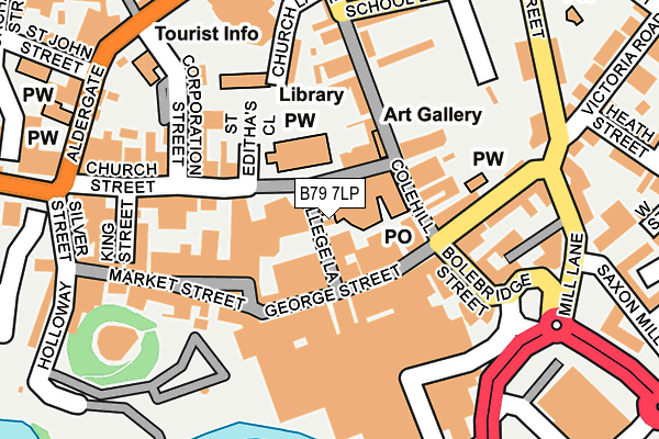
B79 7LP is located in the Castle electoral ward, within the local authority district of Tamworth and the English Parliamentary constituency of Tamworth. The Sub Integrated Care Board (ICB) Location is NHS Staffordshire and Stoke-on-Trent ICB - 05Q and the police force is Staffordshire. This postcode has been in use since January 1980.


GetTheData
Source: OS OpenMap – Local (Ordnance Survey)
Source: OS VectorMap District (Ordnance Survey)
Licence: Open Government Licence (requires attribution)
| Easting | 420818 |
| Northing | 303993 |
| Latitude | 52.633311 |
| Longitude | -1.693831 |
GetTheData
Source: Open Postcode Geo
Licence: Open Government Licence
| Country | England |
| Postcode District | B79 |
| ➜ B79 open data dashboard ➜ See where B79 is on a map ➜ Where is Tamworth? | |
GetTheData
Source: Land Registry Price Paid Data
Licence: Open Government Licence
Elevation or altitude of B79 7LP as distance above sea level:
| Metres | Feet | |
|---|---|---|
| Elevation | 60m | 197ft |
Elevation is measured from the approximate centre of the postcode, to the nearest point on an OS contour line from OS Terrain 50, which has contour spacing of ten vertical metres.
➜ How high above sea level am I? Find the elevation of your current position using your device's GPS.
GetTheData
Source: Open Postcode Elevation
Licence: Open Government Licence
| Ward | Castle |
| Constituency | Tamworth |
GetTheData
Source: ONS Postcode Database
Licence: Open Government Licence
| January 2024 | Public order | On or near Parking Area | 301m |
| January 2024 | Vehicle crime | On or near Parking Area | 301m |
| January 2024 | Violence and sexual offences | On or near Parking Area | 301m |
| ➜ Get more crime data in our Crime section | |||
GetTheData
Source: data.police.uk
Licence: Open Government Licence
| Victoria Road Bus Interchange (Victoria Rd) | Tamworth Town Centre | 120m |
| Bus Interchange (Victoria Rd) | Tamworth Town Centre | 133m |
| Bus Interchange (Victoria Road) | Tamworth Town Centre | 145m |
| Bus Interchange (Corporation St) | Tamworth Town Centre | 162m |
| Bus Interchange (Victoria Road) | Tamworth Town Centre | 169m |
| Tamworth Station | 0.7km |
| Tamworth High Level Station | 0.7km |
| Wilnecote (Staffs) Station | 2.7km |
GetTheData
Source: NaPTAN
Licence: Open Government Licence
GetTheData
Source: ONS Postcode Database
Licence: Open Government Licence


➜ Get more ratings from the Food Standards Agency
GetTheData
Source: Food Standards Agency
Licence: FSA terms & conditions
| Last Collection | |||
|---|---|---|---|
| Location | Mon-Fri | Sat | Distance |
| Tamworth P.o. | 18:45 | 12:30 | 67m |
| 2 Albert Road | 18:30 | 11:30 | 348m |
| Balfour | 18:30 | 11:30 | 351m |
GetTheData
Source: Dracos
Licence: Creative Commons Attribution-ShareAlike
| Facility | Distance |
|---|---|
| Total Fitness Centre (Closed) Mill Lane, Tamworth Health and Fitness Gym | 231m |
| Tamworth Youth Centre (Closed) Spinning School Lane, Tamworth Sports Hall | 322m |
| The Gym Group (Tamworth) River Drive, Tamworth Health and Fitness Gym, Studio | 443m |
GetTheData
Source: Active Places
Licence: Open Government Licence
| School | Phase of Education | Distance |
|---|---|---|
| Mortimer House School Mortimer House, 17 Victoria Road, Tamworth, Staffordshire, B79 7HS | Not applicable | 362m |
| Moorgate Primary Academy Moorgate, Tamworth, B79 7EL | Primary | 469m |
| Kettlebrook Short Stay School Tame Street, Kettlebrook, Tamworth, B77 1AL | Not applicable | 801m |
GetTheData
Source: Edubase
Licence: Open Government Licence
The below table lists the International Territorial Level (ITL) codes (formerly Nomenclature of Territorial Units for Statistics (NUTS) codes) and Local Administrative Units (LAU) codes for B79 7LP:
| ITL 1 Code | Name |
|---|---|
| TLG | West Midlands (England) |
| ITL 2 Code | Name |
| TLG2 | Shropshire and Staffordshire |
| ITL 3 Code | Name |
| TLG24 | Staffordshire CC |
| LAU 1 Code | Name |
| E07000199 | Tamworth |
GetTheData
Source: ONS Postcode Directory
Licence: Open Government Licence
The below table lists the Census Output Area (OA), Lower Layer Super Output Area (LSOA), and Middle Layer Super Output Area (MSOA) for B79 7LP:
| Code | Name | |
|---|---|---|
| OA | E00152039 | |
| LSOA | E01029835 | Tamworth 002A |
| MSOA | E02006218 | Tamworth 002 |
GetTheData
Source: ONS Postcode Directory
Licence: Open Government Licence
| B79 7DE | Church Street | 56m |
| B79 7LQ | George Street | 77m |
| B79 7BX | Church Street | 91m |
| B79 7HE | Colehill | 104m |
| B79 7BA | Lower Gungate | 139m |
| B79 7PA | Bolebridge Street | 139m |
| B79 7DF | Church Street | 153m |
| B79 7LU | Market Street | 167m |
| B79 7LR | Market Street | 169m |
| B79 7AX | Little Church Lane | 169m |
GetTheData
Source: Open Postcode Geo; Land Registry Price Paid Data
Licence: Open Government Licence